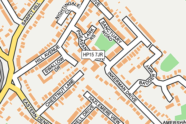
HP15 7JR is located in the Hazlemere electoral ward, within the unitary authority of Buckinghamshire and the English Parliamentary constituency of Wycombe. The Sub Integrated Care Board (ICB) Location is NHS Buckinghamshire, Oxfordshire and Berkshire West ICB - 14Y and the police force is Thames Valley. This postcode has been in use since January 1980.


GetTheData
Source: OS OpenMap – Local (Ordnance Survey)
Source: OS VectorMap District (Ordnance Survey)
Licence: Open Government Licence (requires attribution)
| Easting | 489676 |
| Northing | 196259 |
| Latitude | 51.657973 |
| Longitude | -0.704999 |
GetTheData
Source: Open Postcode Geo
Licence: Open Government Licence
| Country | England |
| Postcode District | HP15 |
| ➜ HP15 open data dashboard ➜ See where HP15 is on a map ➜ Where is Hazlemere? | |
GetTheData
Source: Land Registry Price Paid Data
Licence: Open Government Licence
Elevation or altitude of HP15 7JR as distance above sea level:
| Metres | Feet | |
|---|---|---|
| Elevation | 160m | 525ft |
Elevation is measured from the approximate centre of the postcode, to the nearest point on an OS contour line from OS Terrain 50, which has contour spacing of ten vertical metres.
➜ How high above sea level am I? Find the elevation of your current position using your device's GPS.
GetTheData
Source: Open Postcode Elevation
Licence: Open Government Licence
| Ward | Hazlemere |
| Constituency | Wycombe |
GetTheData
Source: ONS Postcode Database
Licence: Open Government Licence
| November 2023 | Violence and sexual offences | On or near Sawpit Hill | 265m |
| August 2023 | Violence and sexual offences | On or near Sawpit Hill | 265m |
| June 2023 | Violence and sexual offences | On or near Badger Way | 201m |
| ➜ Get more crime data in our Crime section | |||
GetTheData
Source: data.police.uk
Licence: Open Government Licence
| Park Parade (Holmer Green Road) | Hazlemere | 255m |
| Park Parade (Holmer Green Road) | Hazlemere | 323m |
| Sawpit Hill | Hazlemere | 361m |
| Sawpit Hill | Hazlemere | 366m |
| Park Lane (Holmer Green Road) | Hazlemere | 567m |
| High Wycombe Station | 4.2km |
GetTheData
Source: NaPTAN
Licence: Open Government Licence
GetTheData
Source: ONS Postcode Database
Licence: Open Government Licence


➜ Get more ratings from the Food Standards Agency
GetTheData
Source: Food Standards Agency
Licence: FSA terms & conditions
| Last Collection | |||
|---|---|---|---|
| Location | Mon-Fri | Sat | Distance |
| Park Parade P.o. | 16:45 | 12:00 | 350m |
| Watchett Lane | 16:15 | 10:00 | 739m |
| Penn Road | 15:45 | 12:00 | 814m |
GetTheData
Source: Dracos
Licence: Creative Commons Attribution-ShareAlike
| Facility | Distance |
|---|---|
| Hazlemere Golf Club Penn Road, Hazlemere, High Wycombe Golf | 679m |
| Cedar Park School Cedar Avenue, Hazlemere, High Wycombe Swimming Pool, Grass Pitches | 791m |
| Holmer Green Senior School Parish Piece, Holmer Green, High Wycombe Grass Pitches, Sports Hall, Studio, Indoor Tennis Centre | 958m |
GetTheData
Source: Active Places
Licence: Open Government Licence
| School | Phase of Education | Distance |
|---|---|---|
| Cedar Park School & Nursery Cedar Avenue, Hazlemere, High Wycombe, HP15 7EF | Primary | 790m |
| Holmer Green First School and Pre-School Watchet Lane, Holmer Green, High Wycombe, HP15 6UG | Primary | 966m |
| Holmer Green Senior School Parish Piece, Holmer Green, High Wycombe, HP15 6SP | Secondary | 982m |
GetTheData
Source: Edubase
Licence: Open Government Licence
The below table lists the International Territorial Level (ITL) codes (formerly Nomenclature of Territorial Units for Statistics (NUTS) codes) and Local Administrative Units (LAU) codes for HP15 7JR:
| ITL 1 Code | Name |
|---|---|
| TLJ | South East (England) |
| ITL 2 Code | Name |
| TLJ1 | Berkshire, Buckinghamshire and Oxfordshire |
| ITL 3 Code | Name |
| TLJ13 | Buckinghamshire |
| LAU 1 Code | Name |
| E06000060 | Buckinghamshire |
GetTheData
Source: ONS Postcode Directory
Licence: Open Government Licence
The below table lists the Census Output Area (OA), Lower Layer Super Output Area (LSOA), and Middle Layer Super Output Area (MSOA) for HP15 7JR:
| Code | Name | |
|---|---|---|
| OA | E00165837 | |
| LSOA | E01032610 | Wycombe 024F |
| MSOA | E02006824 | Wycombe 024 |
GetTheData
Source: ONS Postcode Directory
Licence: Open Government Licence
| HP15 7JT | Pheasants Drive | 57m |
| HP15 7JF | Lark Rise | 93m |
| HP15 7JU | Hill Avenue | 103m |
| HP15 7JB | Swallow Drive | 112m |
| HP15 7BZ | Chestnut Lane | 132m |
| HP15 7JS | Sanctuary Road | 132m |
| HP15 7JW | Inkerman Drive | 132m |
| HP15 7JX | Hill Avenue | 146m |
| HP15 7JL | Kestrel Drive | 154m |
| HP15 7BY | Hazlemere View | 155m |
GetTheData
Source: Open Postcode Geo; Land Registry Price Paid Data
Licence: Open Government Licence