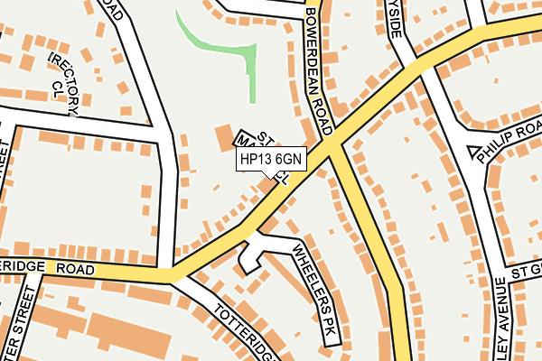
HP13 6GN is located in the Terriers and Amersham Hill electoral ward, within the unitary authority of Buckinghamshire and the English Parliamentary constituency of Wycombe. The Sub Integrated Care Board (ICB) Location is NHS Buckinghamshire, Oxfordshire and Berkshire West ICB - 14Y and the police force is Thames Valley. This postcode has been in use since March 2009.


GetTheData
Source: OS OpenMap – Local (Ordnance Survey)
Source: OS VectorMap District (Ordnance Survey)
Licence: Open Government Licence (requires attribution)
| Easting | 487571 |
| Northing | 193154 |
| Latitude | 51.630394 |
| Longitude | -0.736198 |
GetTheData
Source: Open Postcode Geo
Licence: Open Government Licence
| Country | England |
| Postcode District | HP13 |
| ➜ HP13 open data dashboard ➜ See where HP13 is on a map ➜ Where is High Wycombe? | |
GetTheData
Source: Land Registry Price Paid Data
Licence: Open Government Licence
Elevation or altitude of HP13 6GN as distance above sea level:
| Metres | Feet | |
|---|---|---|
| Elevation | 90m | 295ft |
Elevation is measured from the approximate centre of the postcode, to the nearest point on an OS contour line from OS Terrain 50, which has contour spacing of ten vertical metres.
➜ How high above sea level am I? Find the elevation of your current position using your device's GPS.
GetTheData
Source: Open Postcode Elevation
Licence: Open Government Licence
| Ward | Terriers And Amersham Hill |
| Constituency | Wycombe |
GetTheData
Source: ONS Postcode Database
Licence: Open Government Licence
| January 2024 | Theft from the person | On or near Philip Road | 226m |
| January 2024 | Anti-social behaviour | On or near Philip Road | 226m |
| January 2024 | Anti-social behaviour | On or near Philip Road | 226m |
| ➜ Get more crime data in our Crime section | |||
GetTheData
Source: data.police.uk
Licence: Open Government Licence
| Bowerdean Crossroads (Totteridge Road) | High Wycombe | 46m |
| Bowerdean Crossroads (Bowerdean Road) | High Wycombe | 86m |
| Bowerdean Crossroads (Bowerdean Road) | High Wycombe | 89m |
| Bowerdean Crossroads (Totteridge Road) | High Wycombe | 140m |
| Lucas Road (Totteridge Road) | High Wycombe | 175m |
| High Wycombe Station | 0.6km |
GetTheData
Source: NaPTAN
Licence: Open Government Licence
GetTheData
Source: ONS Postcode Database
Licence: Open Government Licence


➜ Get more ratings from the Food Standards Agency
GetTheData
Source: Food Standards Agency
Licence: FSA terms & conditions
| Last Collection | |||
|---|---|---|---|
| Location | Mon-Fri | Sat | Distance |
| Hatters Lane | 16:30 | 12:00 | 211m |
| Healy Avenue | 16:45 | 12:00 | 221m |
| North Town P.o. | 17:00 | 12:00 | 425m |
GetTheData
Source: Dracos
Licence: Creative Commons Attribution-ShareAlike
| Facility | Distance |
|---|---|
| High Wycombe Cricket Club London Road, High Wycombe Grass Pitches | 601m |
| Highcrest Academy Hatters Lane, High Wycombe Grass Pitches, Sports Hall, Studio, Health and Fitness Gym | 738m |
| Godstowe Preparatory School Shrubbery Road, High Wycombe Sports Hall, Swimming Pool, Grass Pitches | 747m |
GetTheData
Source: Active Places
Licence: Open Government Licence
| School | Phase of Education | Distance |
|---|---|---|
| Hannah Ball School Philip Road, High Wycombe, HP13 7JS | Primary | 335m |
| Hannah Ball School Philip Road, High Wycombe, HP13 7JS | Primary | 336m |
| Bowerdean Nursery School Gordon Road, High Wycombe, HP13 6AW | Nursery | 478m |
GetTheData
Source: Edubase
Licence: Open Government Licence
The below table lists the International Territorial Level (ITL) codes (formerly Nomenclature of Territorial Units for Statistics (NUTS) codes) and Local Administrative Units (LAU) codes for HP13 6GN:
| ITL 1 Code | Name |
|---|---|
| TLJ | South East (England) |
| ITL 2 Code | Name |
| TLJ1 | Berkshire, Buckinghamshire and Oxfordshire |
| ITL 3 Code | Name |
| TLJ13 | Buckinghamshire |
| LAU 1 Code | Name |
| E06000060 | Buckinghamshire |
GetTheData
Source: ONS Postcode Directory
Licence: Open Government Licence
The below table lists the Census Output Area (OA), Lower Layer Super Output Area (LSOA), and Middle Layer Super Output Area (MSOA) for HP13 6GN:
| Code | Name | |
|---|---|---|
| OA | E00090075 | |
| LSOA | E01017851 | Wycombe 010B |
| MSOA | E02003705 | Wycombe 010 |
GetTheData
Source: ONS Postcode Directory
Licence: Open Government Licence
| HP13 6JE | St Marks Close | 33m |
| HP13 6HR | Totteridge Road | 55m |
| HP13 6HZ | Totteridge Road | 58m |
| HP13 6HQ | St Marks Close | 74m |
| HP13 6HP | Lucas Road | 94m |
| HP13 6GH | Wheelers Park | 124m |
| HP13 6XW | Bowerdean Road | 125m |
| HP13 6AZ | Bowerdean Road | 160m |
| HP13 6AY | Bowerdean Road | 174m |
| HP13 7LA | Totteridge Road | 189m |
GetTheData
Source: Open Postcode Geo; Land Registry Price Paid Data
Licence: Open Government Licence