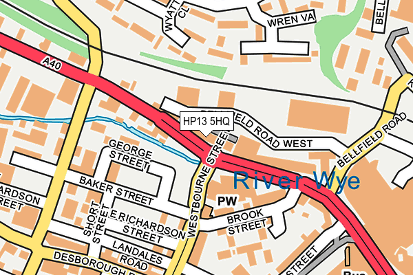
HP13 5HQ is located in the Abbey electoral ward, within the unitary authority of Buckinghamshire and the English Parliamentary constituency of Wycombe. The Sub Integrated Care Board (ICB) Location is NHS Buckinghamshire, Oxfordshire and Berkshire West ICB - 14Y and the police force is Thames Valley. This postcode has been in use since February 1990.


GetTheData
Source: OS OpenMap – Local (Ordnance Survey)
Source: OS VectorMap District (Ordnance Survey)
Licence: Open Government Licence (requires attribution)
| Easting | 485997 |
| Northing | 193439 |
| Latitude | 51.633201 |
| Longitude | -0.758844 |
GetTheData
Source: Open Postcode Geo
Licence: Open Government Licence
| Country | England |
| Postcode District | HP13 |
| ➜ HP13 open data dashboard ➜ See where HP13 is on a map ➜ Where is High Wycombe? | |
GetTheData
Source: Land Registry Price Paid Data
Licence: Open Government Licence
Elevation or altitude of HP13 5HQ as distance above sea level:
| Metres | Feet | |
|---|---|---|
| Elevation | 80m | 262ft |
Elevation is measured from the approximate centre of the postcode, to the nearest point on an OS contour line from OS Terrain 50, which has contour spacing of ten vertical metres.
➜ How high above sea level am I? Find the elevation of your current position using your device's GPS.
GetTheData
Source: Open Postcode Elevation
Licence: Open Government Licence
| Ward | Abbey |
| Constituency | Wycombe |
GetTheData
Source: ONS Postcode Database
Licence: Open Government Licence
| September 2023 | Violence and sexual offences | On or near Parking Area | 106m |
| September 2023 | Violence and sexual offences | On or near Parking Area | 106m |
| September 2023 | Violence and sexual offences | On or near Parking Area | 106m |
| ➜ Get more crime data in our Crime section | |||
GetTheData
Source: data.police.uk
Licence: Open Government Licence
| Riverside (West Wycombe Road) | High Wycombe | 86m |
| Riverside (West Wycombe Road) | High Wycombe | 92m |
| Brook Street (West Wycombe Road) | High Wycombe | 97m |
| Baker Street (Desborough Avenue) | High Wycombe | 186m |
| Baker Street (Desborough Avenue) | High Wycombe | 201m |
| High Wycombe Station | 1km |
| Saunderton Station | 6.6km |
GetTheData
Source: NaPTAN
Licence: Open Government Licence
GetTheData
Source: ONS Postcode Database
Licence: Open Government Licence


➜ Get more ratings from the Food Standards Agency
GetTheData
Source: Food Standards Agency
Licence: FSA terms & conditions
| Last Collection | |||
|---|---|---|---|
| Location | Mon-Fri | Sat | Distance |
| Desborough Avenue | 18:30 | 12:00 | 197m |
| Desborough Road P.o. | 18:30 | 12:00 | 243m |
| Safeways | 17:00 | 12:00 | 393m |
GetTheData
Source: Dracos
Licence: Creative Commons Attribution-ShareAlike
| Facility | Distance |
|---|---|
| Anytime Fitness (High Wycombe) Newland Street, High Wycombe Health and Fitness Gym, Studio | 537m |
| Buzz Gym (High Wycombe) Welcome Hall, High Wycombe Health and Fitness Gym, Studio | 558m |
| Gymfit4less West Wycombe Road, High Wycombe Health and Fitness Gym, Studio | 749m |
GetTheData
Source: Active Places
Licence: Open Government Licence
| School | Phase of Education | Distance |
|---|---|---|
| Hamilton Academy Priory Avenue, High Wycombe, HP13 6SG | Primary | 559m |
| High Wycombe Church of England Combined School Loakes Road, High Wycombe, HP11 2JU | Primary | 662m |
| Buckinghamshire New University Queen Alexandra Road, High Wycombe, HP11 2JZ | Not applicable | 789m |
GetTheData
Source: Edubase
Licence: Open Government Licence
The below table lists the International Territorial Level (ITL) codes (formerly Nomenclature of Territorial Units for Statistics (NUTS) codes) and Local Administrative Units (LAU) codes for HP13 5HQ:
| ITL 1 Code | Name |
|---|---|
| TLJ | South East (England) |
| ITL 2 Code | Name |
| TLJ1 | Berkshire, Buckinghamshire and Oxfordshire |
| ITL 3 Code | Name |
| TLJ13 | Buckinghamshire |
| LAU 1 Code | Name |
| E06000060 | Buckinghamshire |
GetTheData
Source: ONS Postcode Directory
Licence: Open Government Licence
The below table lists the Census Output Area (OA), Lower Layer Super Output Area (LSOA), and Middle Layer Super Output Area (MSOA) for HP13 5HQ:
| Code | Name | |
|---|---|---|
| OA | E00172600 | |
| LSOA | E01017837 | Wycombe 015B |
| MSOA | E02003710 | Wycombe 015 |
GetTheData
Source: ONS Postcode Directory
Licence: Open Government Licence
| HP13 5HW | Buckingham Place | 6m |
| HP11 2LW | West Wycombe Road | 68m |
| HP11 2LQ | West Wycombe Road | 108m |
| HP11 2EQ | Brook Street | 114m |
| HP13 5YU | Wyatt Close | 119m |
| HP11 2DX | Oxford Road | 157m |
| HP13 5YT | Garratts Way | 177m |
| HP11 2PZ | Westbourne Street | 182m |
| HP13 5YX | Wyatt Close | 205m |
| HP11 2QH | Short Street | 218m |
GetTheData
Source: Open Postcode Geo; Land Registry Price Paid Data
Licence: Open Government Licence