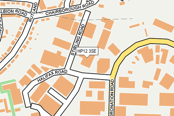
HP12 3SE is located in the Abbey electoral ward, within the unitary authority of Buckinghamshire and the English Parliamentary constituency of Wycombe. The Sub Integrated Care Board (ICB) Location is NHS Buckinghamshire, Oxfordshire and Berkshire West ICB - 14Y and the police force is Thames Valley. This postcode has been in use since January 1980.


GetTheData
Source: OS OpenMap – Local (Ordnance Survey)
Source: OS VectorMap District (Ordnance Survey)
Licence: Open Government Licence (requires attribution)
| Easting | 484669 |
| Northing | 192091 |
| Latitude | 51.621285 |
| Longitude | -0.778352 |
GetTheData
Source: Open Postcode Geo
Licence: Open Government Licence
| Country | England |
| Postcode District | HP12 |
| ➜ HP12 open data dashboard ➜ See where HP12 is on a map ➜ Where is High Wycombe? | |
GetTheData
Source: Land Registry Price Paid Data
Licence: Open Government Licence
Elevation or altitude of HP12 3SE as distance above sea level:
| Metres | Feet | |
|---|---|---|
| Elevation | 150m | 492ft |
Elevation is measured from the approximate centre of the postcode, to the nearest point on an OS contour line from OS Terrain 50, which has contour spacing of ten vertical metres.
➜ How high above sea level am I? Find the elevation of your current position using your device's GPS.
GetTheData
Source: Open Postcode Elevation
Licence: Open Government Licence
| Ward | Abbey |
| Constituency | Wycombe |
GetTheData
Source: ONS Postcode Database
Licence: Open Government Licence
| January 2024 | Possession of weapons | On or near Birinus Close | 383m |
| August 2023 | Possession of weapons | On or near Birinus Close | 383m |
| July 2023 | Other theft | On or near Birinus Close | 383m |
| ➜ Get more crime data in our Crime section | |||
GetTheData
Source: data.police.uk
Licence: Open Government Licence
| Halifax Road (Coronation Road) | Cressex | 126m |
| Halifax Road (Coronation Road) | Cressex | 136m |
| The Jolly Bodger Ph (Chairborough Road) | Desborough Castle | 213m |
| Lincoln Road (Coronation Road) | Cressex | 291m |
| Pettifer Way (Chairborough Road) | Desborough Castle | 309m |
| High Wycombe Station | 2.5km |
| Bourne End Station | 6.8km |
GetTheData
Source: NaPTAN
Licence: Open Government Licence
GetTheData
Source: ONS Postcode Database
Licence: Open Government Licence


➜ Get more ratings from the Food Standards Agency
GetTheData
Source: Food Standards Agency
Licence: FSA terms & conditions
| Last Collection | |||
|---|---|---|---|
| Location | Mon-Fri | Sat | Distance |
| Halifax Road | 18:30 | 12:00 | 119m |
| Coronation Road | 18:30 | 12:00 | 332m |
| Lancaster Road | 18:30 | 525m | |
GetTheData
Source: Dracos
Licence: Creative Commons Attribution-ShareAlike
| Facility | Distance |
|---|---|
| Asylum Gym (Closed) Halifax Road, Cressex Business Park, High Wycombe Health and Fitness Gym | 262m |
| Castlefield School Middle Way, High Wycombe Grass Pitches | 557m |
| Chepping View Primary Academy Cressex Road, High Wycombe Grass Pitches, Artificial Grass Pitch | 693m |
GetTheData
Source: Active Places
Licence: Open Government Licence
| School | Phase of Education | Distance |
|---|---|---|
| Chiltern Wood School Verney Avenue, High Wycombe, HP12 3NE | Not applicable | 434m |
| Kite Ridge School Verney Avenue, High Wycombe, HP12 3NE | Not applicable | 467m |
| Castlefield School The Middle Way, High Wycombe, HP12 3LE | Primary | 556m |
GetTheData
Source: Edubase
Licence: Open Government Licence
The below table lists the International Territorial Level (ITL) codes (formerly Nomenclature of Territorial Units for Statistics (NUTS) codes) and Local Administrative Units (LAU) codes for HP12 3SE:
| ITL 1 Code | Name |
|---|---|
| TLJ | South East (England) |
| ITL 2 Code | Name |
| TLJ1 | Berkshire, Buckinghamshire and Oxfordshire |
| ITL 3 Code | Name |
| TLJ13 | Buckinghamshire |
| LAU 1 Code | Name |
| E06000060 | Buckinghamshire |
GetTheData
Source: ONS Postcode Directory
Licence: Open Government Licence
The below table lists the Census Output Area (OA), Lower Layer Super Output Area (LSOA), and Middle Layer Super Output Area (MSOA) for HP12 3SE:
| Code | Name | |
|---|---|---|
| OA | E00090001 | |
| LSOA | E01017836 | Wycombe 015A |
| MSOA | E02003710 | Wycombe 015 |
GetTheData
Source: ONS Postcode Directory
Licence: Open Government Licence
| HP12 3RP | Coronation Road | 180m |
| HP12 3SN | Halifax Road | 254m |
| HP12 3HP | Chairborough Road | 261m |
| HP12 3SD | Halifax Road | 274m |
| HP12 3UE | Chairborough Road | 274m |
| HP12 3UF | Chiltern Avenue | 274m |
| HP12 3UL | Chairborough Road | 283m |
| HP12 3LY | Rutland Avenue | 304m |
| HP12 3LG | Rutland Avenue | 311m |
| HP12 3LN | Rutland Avenue | 330m |
GetTheData
Source: Open Postcode Geo; Land Registry Price Paid Data
Licence: Open Government Licence