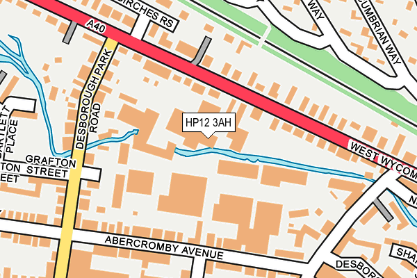
HP12 3AH is located in the Booker, Cressex and Castlefield electoral ward, within the unitary authority of Buckinghamshire and the English Parliamentary constituency of Wycombe. The Sub Integrated Care Board (ICB) Location is NHS Buckinghamshire, Oxfordshire and Berkshire West ICB - 14Y and the police force is Thames Valley. This postcode has been in use since May 1994.


GetTheData
Source: OS OpenMap – Local (Ordnance Survey)
Source: OS VectorMap District (Ordnance Survey)
Licence: Open Government Licence (requires attribution)
| Easting | 485266 |
| Northing | 193693 |
| Latitude | 51.635592 |
| Longitude | -0.769361 |
GetTheData
Source: Open Postcode Geo
Licence: Open Government Licence
| Country | England |
| Postcode District | HP12 |
| ➜ HP12 open data dashboard ➜ See where HP12 is on a map ➜ Where is High Wycombe? | |
GetTheData
Source: Land Registry Price Paid Data
Licence: Open Government Licence
Elevation or altitude of HP12 3AH as distance above sea level:
| Metres | Feet | |
|---|---|---|
| Elevation | 80m | 262ft |
Elevation is measured from the approximate centre of the postcode, to the nearest point on an OS contour line from OS Terrain 50, which has contour spacing of ten vertical metres.
➜ How high above sea level am I? Find the elevation of your current position using your device's GPS.
GetTheData
Source: Open Postcode Elevation
Licence: Open Government Licence
| Ward | Booker, Cressex And Castlefield |
| Constituency | Wycombe |
GetTheData
Source: ONS Postcode Database
Licence: Open Government Licence
| January 2024 | Other crime | On or near Cheviot Close | 343m |
| January 2024 | Other theft | On or near Fryers Lane | 384m |
| January 2024 | Other theft | On or near Fryers Lane | 384m |
| ➜ Get more crime data in our Crime section | |||
GetTheData
Source: data.police.uk
Licence: Open Government Licence
| Desborough Park Road (West Wycombe Road) | High Wycombe | 168m |
| The White Horse Ph (West Wycombe Road) | High Wycombe | 233m |
| Brecon Way | High Wycombe | 242m |
| Brecon Way | High Wycombe | 248m |
| Cotswold Way | High Wycombe | 252m |
| High Wycombe Station | 1.8km |
| Saunderton Station | 5.9km |
GetTheData
Source: NaPTAN
Licence: Open Government Licence
GetTheData
Source: ONS Postcode Database
Licence: Open Government Licence


➜ Get more ratings from the Food Standards Agency
GetTheData
Source: Food Standards Agency
Licence: FSA terms & conditions
| Last Collection | |||
|---|---|---|---|
| Location | Mon-Fri | Sat | Distance |
| Desborough Park Road | 16:45 | 12:00 | 169m |
| Abercromby Avenue | 18:15 | 12:00 | 228m |
| Green Street P.o. | 18:15 | 12:00 | 292m |
GetTheData
Source: Dracos
Licence: Creative Commons Attribution-ShareAlike
| Facility | Distance |
|---|---|
| Titans Gym Desborough Park Road, High Wycombe Health and Fitness Gym, Studio | 48m |
| Gymfit4less West Wycombe Road, High Wycombe Health and Fitness Gym, Studio | 63m |
| Desborough Recreation Ground Fryers Lane, High Wycombe Grass Pitches, Outdoor Tennis Courts | 391m |
GetTheData
Source: Active Places
Licence: Open Government Licence
| School | Phase of Education | Distance |
|---|---|---|
| Unity College 150 West Wycombe Road, High Wycombe, HP12 3AE | Not applicable | 110m |
| Oakridge School Oakridge Road, High Wycombe, HP11 2PN | Primary | 579m |
| The Disraeli School The Pastures, High Wycombe, HP13 5JS | Primary | 582m |
GetTheData
Source: Edubase
Licence: Open Government Licence
The below table lists the International Territorial Level (ITL) codes (formerly Nomenclature of Territorial Units for Statistics (NUTS) codes) and Local Administrative Units (LAU) codes for HP12 3AH:
| ITL 1 Code | Name |
|---|---|
| TLJ | South East (England) |
| ITL 2 Code | Name |
| TLJ1 | Berkshire, Buckinghamshire and Oxfordshire |
| ITL 3 Code | Name |
| TLJ13 | Buckinghamshire |
| LAU 1 Code | Name |
| E06000060 | Buckinghamshire |
GetTheData
Source: ONS Postcode Directory
Licence: Open Government Licence
The below table lists the Census Output Area (OA), Lower Layer Super Output Area (LSOA), and Middle Layer Super Output Area (MSOA) for HP12 3AH:
| Code | Name | |
|---|---|---|
| OA | E00090322 | |
| LSOA | E01017905 | Wycombe 013C |
| MSOA | E02003708 | Wycombe 013 |
GetTheData
Source: ONS Postcode Directory
Licence: Open Government Licence
| HP12 3AF | West Wycombe Road | 98m |
| HP12 3QG | West Wycombe Road | 124m |
| HP12 3AE | West Wycombe Road | 128m |
| HP12 3GW | Abercromby Avenue | 138m |
| HP12 3BA | The Willows | 150m |
| HP12 3AA | West Wycombe Road | 163m |
| HP12 3AB | West Wycombe Road | 164m |
| HP12 3BQ | Desborough Park Road | 170m |
| HP12 3BD | Abercromby Avenue | 177m |
| HP12 3BG | Desborough Park Road | 178m |
GetTheData
Source: Open Postcode Geo; Land Registry Price Paid Data
Licence: Open Government Licence