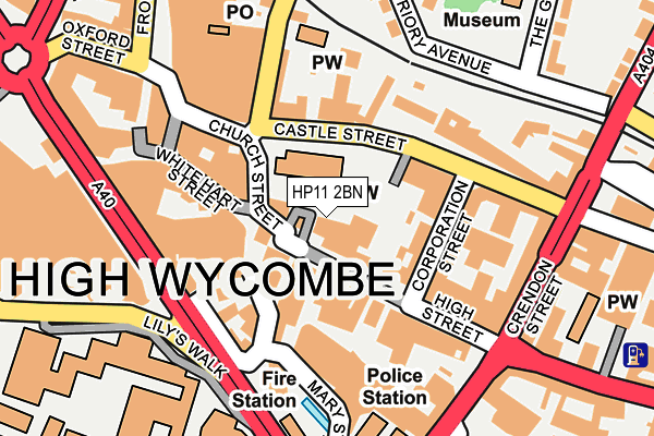
HP11 2BN lies on Church Square in High Wycombe. HP11 2BN is located in the Abbey electoral ward, within the unitary authority of Buckinghamshire and the English Parliamentary constituency of Wycombe. The Sub Integrated Care Board (ICB) Location is NHS Buckinghamshire, Oxfordshire and Berkshire West ICB - 14Y and the police force is Thames Valley. This postcode has been in use since January 1980.


GetTheData
Source: OS OpenMap – Local (Ordnance Survey)
Source: OS VectorMap District (Ordnance Survey)
Licence: Open Government Licence (requires attribution)
| Easting | 486581 |
| Northing | 193036 |
| Latitude | 51.629486 |
| Longitude | -0.750527 |
GetTheData
Source: Open Postcode Geo
Licence: Open Government Licence
| Street | Church Square |
| Town/City | High Wycombe |
| Country | England |
| Postcode District | HP11 |
| ➜ HP11 open data dashboard ➜ See where HP11 is on a map ➜ Where is High Wycombe? | |
GetTheData
Source: Land Registry Price Paid Data
Licence: Open Government Licence
Elevation or altitude of HP11 2BN as distance above sea level:
| Metres | Feet | |
|---|---|---|
| Elevation | 70m | 230ft |
Elevation is measured from the approximate centre of the postcode, to the nearest point on an OS contour line from OS Terrain 50, which has contour spacing of ten vertical metres.
➜ How high above sea level am I? Find the elevation of your current position using your device's GPS.
GetTheData
Source: Open Postcode Elevation
Licence: Open Government Licence
| Ward | Abbey |
| Constituency | Wycombe |
GetTheData
Source: ONS Postcode Database
Licence: Open Government Licence
COSTA COFFEE, 1 - 2, CHURCH SQUARE, HIGH WYCOMBE, HP11 2BN 2004 24 MAR £752,500 |
GetTheData
Source: HM Land Registry Price Paid Data
Licence: Contains HM Land Registry data © Crown copyright and database right 2024. This data is licensed under the Open Government Licence v3.0.
| January 2024 | Anti-social behaviour | On or near Parking Area | 285m |
| January 2024 | Criminal damage and arson | On or near Parking Area | 285m |
| January 2024 | Possession of weapons | On or near Parking Area | 285m |
| ➜ Church Square crime map and outcomes | |||
GetTheData
Source: data.police.uk
Licence: Open Government Licence
| High Street | High Wycombe | 127m |
| High Street | High Wycombe | 145m |
| Castle Street | High Wycombe | 178m |
| Castle Street | High Wycombe | 186m |
| Crendon Street | High Wycombe | 197m |
| High Wycombe Station | 0.4km |
GetTheData
Source: NaPTAN
Licence: Open Government Licence
GetTheData
Source: ONS Postcode Database
Licence: Open Government Licence


➜ Get more ratings from the Food Standards Agency
GetTheData
Source: Food Standards Agency
Licence: FSA terms & conditions
| Last Collection | |||
|---|---|---|---|
| Location | Mon-Fri | Sat | Distance |
| Guildhall | 18:30 | 12:00 | 68m |
| Chilterns Bo | 17:30 | 12:00 | 96m |
| White Hart Street | 17:00 | 177m | |
GetTheData
Source: Dracos
Licence: Creative Commons Attribution-ShareAlike
| Facility | Distance |
|---|---|
| The Gym Group (High Wycombe) Castle Street, High Wycombe Health and Fitness Gym | 98m |
| Buzz Gym (High Wycombe) Welcome Hall, High Wycombe Health and Fitness Gym, Studio | 223m |
| Buckinghamshire New University (High Wycombe Campus) (Closed) Queen Alexandra Road, High Wycombe Sports Hall, Health and Fitness Gym | 243m |
GetTheData
Source: Active Places
Licence: Open Government Licence
| School | Phase of Education | Distance |
|---|---|---|
| Buckinghamshire New University Queen Alexandra Road, High Wycombe, HP11 2JZ | Not applicable | 243m |
| Hamilton Academy Priory Avenue, High Wycombe, HP13 6SG | Primary | 303m |
| High Wycombe Church of England Combined School Loakes Road, High Wycombe, HP11 2JU | Primary | 496m |
GetTheData
Source: Edubase
Licence: Open Government Licence
The below table lists the International Territorial Level (ITL) codes (formerly Nomenclature of Territorial Units for Statistics (NUTS) codes) and Local Administrative Units (LAU) codes for HP11 2BN:
| ITL 1 Code | Name |
|---|---|
| TLJ | South East (England) |
| ITL 2 Code | Name |
| TLJ1 | Berkshire, Buckinghamshire and Oxfordshire |
| ITL 3 Code | Name |
| TLJ13 | Buckinghamshire |
| LAU 1 Code | Name |
| E06000060 | Buckinghamshire |
GetTheData
Source: ONS Postcode Directory
Licence: Open Government Licence
The below table lists the Census Output Area (OA), Lower Layer Super Output Area (LSOA), and Middle Layer Super Output Area (MSOA) for HP11 2BN:
| Code | Name | |
|---|---|---|
| OA | E00172606 | |
| LSOA | E01017839 | Wycombe 015D |
| MSOA | E02003710 | Wycombe 015 |
GetTheData
Source: ONS Postcode Directory
Licence: Open Government Licence
| HP11 2AZ | High Street | 35m |
| HP13 6TA | Corporation Street | 84m |
| HP13 6RZ | Castle Street | 94m |
| HP11 2DE | Church Street | 98m |
| HP11 2HF | Crown Lane | 109m |
| HP13 6TQ | Corporation Street | 114m |
| HP13 6RX | Castle Place | 119m |
| HP11 2AG | High Street | 121m |
| HP13 6RU | Castle Street | 129m |
| HP11 2HL | White Hart Street | 130m |
GetTheData
Source: Open Postcode Geo; Land Registry Price Paid Data
Licence: Open Government Licence