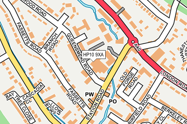
HP10 9XA is located in the Tylers Green and Loudwater electoral ward, within the unitary authority of Buckinghamshire and the English Parliamentary constituency of Wycombe. The Sub Integrated Care Board (ICB) Location is NHS Buckinghamshire, Oxfordshire and Berkshire West ICB - 14Y and the police force is Thames Valley. This postcode has been in use since January 1980.


GetTheData
Source: OS OpenMap – Local (Ordnance Survey)
Source: OS VectorMap District (Ordnance Survey)
Licence: Open Government Licence (requires attribution)
| Easting | 490103 |
| Northing | 190737 |
| Latitude | 51.608271 |
| Longitude | -0.700228 |
GetTheData
Source: Open Postcode Geo
Licence: Open Government Licence
| Country | England |
| Postcode District | HP10 |
| ➜ HP10 open data dashboard ➜ See where HP10 is on a map ➜ Where is Loudwater? | |
GetTheData
Source: Land Registry Price Paid Data
Licence: Open Government Licence
Elevation or altitude of HP10 9XA as distance above sea level:
| Metres | Feet | |
|---|---|---|
| Elevation | 50m | 164ft |
Elevation is measured from the approximate centre of the postcode, to the nearest point on an OS contour line from OS Terrain 50, which has contour spacing of ten vertical metres.
➜ How high above sea level am I? Find the elevation of your current position using your device's GPS.
GetTheData
Source: Open Postcode Elevation
Licence: Open Government Licence
| Ward | Tylers Green And Loudwater |
| Constituency | Wycombe |
GetTheData
Source: ONS Postcode Database
Licence: Open Government Licence
THE ROYAL BRITISH LEGION, QUEENSMEAD ROAD, LOUDWATER, HIGH WYCOMBE, HP10 9XA 2022 11 AUG £1,400,000 |
GetTheData
Source: HM Land Registry Price Paid Data
Licence: Contains HM Land Registry data © Crown copyright and database right 2024. This data is licensed under the Open Government Licence v3.0.
| January 2024 | Violence and sexual offences | On or near Station Road | 77m |
| January 2024 | Vehicle crime | On or near Station Road | 77m |
| January 2024 | Violence and sexual offences | On or near Snakeley Close | 291m |
| ➜ Get more crime data in our Crime section | |||
GetTheData
Source: data.police.uk
Licence: Open Government Licence
| Loudwater Turn (London Road) | Loudwater | 164m |
| Station Road | Loudwater | 176m |
| Station Road | Loudwater | 183m |
| St Peter's Close (Kingsmead Road) | Loudwater | 224m |
| St Peter's Close (Kingsmead Road) | Loudwater | 233m |
| Bourne End Station | 3.5km |
| Beaconsfield Station | 3.9km |
| High Wycombe Station | 3.9km |
GetTheData
Source: NaPTAN
Licence: Open Government Licence
GetTheData
Source: ONS Postcode Database
Licence: Open Government Licence


➜ Get more ratings from the Food Standards Agency
GetTheData
Source: Food Standards Agency
Licence: FSA terms & conditions
| Last Collection | |||
|---|---|---|---|
| Location | Mon-Fri | Sat | Distance |
| Loudwater P.o. | 17:00 | 11:40 | 97m |
| Kingsmill | 16:00 | 09:30 | 305m |
| Knaves Beech | 18:15 | 515m | |
GetTheData
Source: Dracos
Licence: Creative Commons Attribution-ShareAlike
| Facility | Distance |
|---|---|
| Wild Training Gym Treadaway Tech Centre, Treadaway Hill, Loudwater, High Wycombe Studio | 454m |
| Derehams Lane Derehams Lane, Loudwater, High Wycombe Grass Pitches | 528m |
| Flackwell Heath Golf Club Treadaway Road, Flackwell Heath, High Wycombe Golf | 653m |
GetTheData
Source: Active Places
Licence: Open Government Licence
| School | Phase of Education | Distance |
|---|---|---|
| Loudwater Combined School School Way, Kingsmead Road, Loudwater Combined School, High Wycombe, HP11 1JJ | Primary | 465m |
| Carrington Junior School 4 Chapel Road, Flackwell Heath, High Wycombe, HP10 9AA | Primary | 1.1km |
| Carrington Infant School 2 Chapel Road, Flackwell Heath, High Wycombe, HP10 9AA | Primary | 1.1km |
GetTheData
Source: Edubase
Licence: Open Government Licence
The below table lists the International Territorial Level (ITL) codes (formerly Nomenclature of Territorial Units for Statistics (NUTS) codes) and Local Administrative Units (LAU) codes for HP10 9XA:
| ITL 1 Code | Name |
|---|---|
| TLJ | South East (England) |
| ITL 2 Code | Name |
| TLJ1 | Berkshire, Buckinghamshire and Oxfordshire |
| ITL 3 Code | Name |
| TLJ13 | Buckinghamshire |
| LAU 1 Code | Name |
| E06000060 | Buckinghamshire |
GetTheData
Source: ONS Postcode Directory
Licence: Open Government Licence
The below table lists the Census Output Area (OA), Lower Layer Super Output Area (LSOA), and Middle Layer Super Output Area (MSOA) for HP10 9XA:
| Code | Name | |
|---|---|---|
| OA | E00090509 | |
| LSOA | E01017941 | Wycombe 016D |
| MSOA | E02003711 | Wycombe 016 |
GetTheData
Source: ONS Postcode Directory
Licence: Open Government Licence
| HP10 9TX | Station Road | 64m |
| HP10 9XD | Queensmead Road | 67m |
| HP10 9XE | Queensmead Road | 85m |
| HP10 9XF | Queensmead Road | 99m |
| HP10 9UW | Fassetts Road | 102m |
| HP10 9TZ | Station Road | 107m |
| HP10 9SX | Station Road | 116m |
| HP10 9TP | Old Forge Road | 119m |
| HP10 9TJ | London Road | 127m |
| HP10 9TH | Providence Villas | 144m |
GetTheData
Source: Open Postcode Geo; Land Registry Price Paid Data
Licence: Open Government Licence