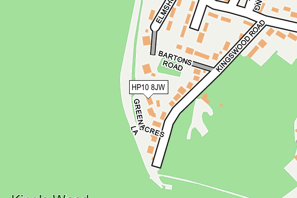
HP10 8JW lies on Greenacres Lane in Penn, High Wycombe. HP10 8JW is located in the Tylers Green and Loudwater electoral ward, within the unitary authority of Buckinghamshire and the English Parliamentary constituency of Wycombe. The Sub Integrated Care Board (ICB) Location is NHS Buckinghamshire, Oxfordshire and Berkshire West ICB - 14Y and the police force is Thames Valley. This postcode has been in use since January 1980.


GetTheData
Source: OS OpenMap – Local (Ordnance Survey)
Source: OS VectorMap District (Ordnance Survey)
Licence: Open Government Licence (requires attribution)
| Easting | 489110 |
| Northing | 194266 |
| Latitude | 51.640148 |
| Longitude | -0.713687 |
GetTheData
Source: Open Postcode Geo
Licence: Open Government Licence
| Street | Greenacres Lane |
| Locality | Penn |
| Town/City | High Wycombe |
| Country | England |
| Postcode District | HP10 |
| ➜ HP10 open data dashboard ➜ See where HP10 is on a map ➜ Where is Tylers Green? | |
GetTheData
Source: Land Registry Price Paid Data
Licence: Open Government Licence
Elevation or altitude of HP10 8JW as distance above sea level:
| Metres | Feet | |
|---|---|---|
| Elevation | 120m | 394ft |
Elevation is measured from the approximate centre of the postcode, to the nearest point on an OS contour line from OS Terrain 50, which has contour spacing of ten vertical metres.
➜ How high above sea level am I? Find the elevation of your current position using your device's GPS.
GetTheData
Source: Open Postcode Elevation
Licence: Open Government Licence
| Ward | Tylers Green And Loudwater |
| Constituency | Wycombe |
GetTheData
Source: ONS Postcode Database
Licence: Open Government Licence
| June 2022 | Violence and sexual offences | On or near Manor Road | 482m |
| April 2022 | Vehicle crime | On or near Hillside Road | 270m |
| March 2022 | Anti-social behaviour | On or near Greenacres Lane | 48m |
| ➜ Greenacres Lane crime map and outcomes | |||
GetTheData
Source: data.police.uk
Licence: Open Government Licence
| The Dolphin Ph (Totteridge Lane) | Totteridge | 582m |
| Woodside Road (Micklefield Road) | Micklefield Estate | 606m |
| The Dolphin Ph (Totteridge Lane) | Totteridge | 615m |
| Woodside Road (Micklefield Road) | Micklefield Estate | 625m |
| Tyzack Road (Totteridge Lane) | Totteridge | 673m |
| High Wycombe Station | 2.5km |
| Beaconsfield Station | 5.8km |
GetTheData
Source: NaPTAN
Licence: Open Government Licence
| Percentage of properties with Next Generation Access | 100.0% |
| Percentage of properties with Superfast Broadband | 100.0% |
| Percentage of properties with Ultrafast Broadband | 0.0% |
| Percentage of properties with Full Fibre Broadband | 0.0% |
Superfast Broadband is between 30Mbps and 300Mbps
Ultrafast Broadband is > 300Mbps
| Percentage of properties unable to receive 2Mbps | 0.0% |
| Percentage of properties unable to receive 5Mbps | 0.0% |
| Percentage of properties unable to receive 10Mbps | 0.0% |
| Percentage of properties unable to receive 30Mbps | 0.0% |
GetTheData
Source: Ofcom
Licence: Ofcom Terms of Use (requires attribution)
GetTheData
Source: ONS Postcode Database
Licence: Open Government Licence

➜ Get more ratings from the Food Standards Agency
GetTheData
Source: Food Standards Agency
Licence: FSA terms & conditions
| Last Collection | |||
|---|---|---|---|
| Location | Mon-Fri | Sat | Distance |
| Manor Road | 16:30 | 11:45 | 444m |
| Tyzack Road | 16:45 | 12:00 | 586m |
| St Johns Road | 16:00 | 09:30 | 885m |
GetTheData
Source: Dracos
Licence: Creative Commons Attribution-ShareAlike
| Facility | Distance |
|---|---|
| Polish Klub Forest Way, High Wycombe Sports Hall | 669m |
| Sir William Ramsay School Rose Avenue, Hazlemere, High Wycombe Sports Hall, Grass Pitches, Studio, Health and Fitness Gym | 816m |
| Hazlemere Community Centre Rose Avenue, Hazlemere, High Wycombe Sports Hall | 858m |
GetTheData
Source: Active Places
Licence: Open Government Licence
| School | Phase of Education | Distance |
|---|---|---|
| Sir William Ramsay School Rose Avenue, Hazlemere, High Wycombe, HP15 7UB | Secondary | 784m |
| Manor Farm Community Infant School Rose Avenue, Hazlemere, High Wycombe, HP15 7PH | Primary | 852m |
| Kings Wood School and Nursery Hollis Road, High Wycombe, HP13 7UN | Primary | 885m |
GetTheData
Source: Edubase
Licence: Open Government Licence
The below table lists the International Territorial Level (ITL) codes (formerly Nomenclature of Territorial Units for Statistics (NUTS) codes) and Local Administrative Units (LAU) codes for HP10 8JW:
| ITL 1 Code | Name |
|---|---|
| TLJ | South East (England) |
| ITL 2 Code | Name |
| TLJ1 | Berkshire, Buckinghamshire and Oxfordshire |
| ITL 3 Code | Name |
| TLJ13 | Buckinghamshire |
| LAU 1 Code | Name |
| E06000060 | Buckinghamshire |
GetTheData
Source: ONS Postcode Directory
Licence: Open Government Licence
The below table lists the Census Output Area (OA), Lower Layer Super Output Area (LSOA), and Middle Layer Super Output Area (MSOA) for HP10 8JW:
| Code | Name | |
|---|---|---|
| OA | E00090495 | |
| LSOA | E01017938 | Wycombe 009B |
| MSOA | E02003704 | Wycombe 009 |
GetTheData
Source: ONS Postcode Directory
Licence: Open Government Licence
| HP10 8JL | Kingswood Road | 103m |
| HP10 8JN | Bartons Road | 127m |
| HP10 8JR | Elmshott Close | 153m |
| HP10 8JP | Silverdale Close | 186m |
| HP10 8JJ | Hillside Road | 320m |
| HP10 8JH | Chepping Close | 325m |
| HP10 8JE | Kingswood Road | 329m |
| HP10 8QZ | Beeches Grove | 345m |
| HP10 8JQ | The Thicket | 346m |
| HP10 8JS | Southcote Way | 426m |
GetTheData
Source: Open Postcode Geo; Land Registry Price Paid Data
Licence: Open Government Licence