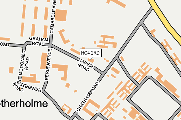
HG4 2RD is located in the Ripon Ure Bank & Spa electoral ward, within the unitary authority of North Yorkshire and the English Parliamentary constituency of Skipton and Ripon. The Sub Integrated Care Board (ICB) Location is NHS Humber and North Yorkshire ICB - 42D and the police force is North Yorkshire. This postcode has been in use since January 1980.


GetTheData
Source: OS OpenMap – Local (Ordnance Survey)
Source: OS VectorMap District (Ordnance Survey)
Licence: Open Government Licence (requires attribution)
| Easting | 429492 |
| Northing | 472197 |
| Latitude | 54.144763 |
| Longitude | -1.550021 |
GetTheData
Source: Open Postcode Geo
Licence: Open Government Licence
| Country | England |
| Postcode District | HG4 |
| ➜ HG4 open data dashboard ➜ See where HG4 is on a map ➜ Where is Ripon? | |
GetTheData
Source: Land Registry Price Paid Data
Licence: Open Government Licence
Elevation or altitude of HG4 2RD as distance above sea level:
| Metres | Feet | |
|---|---|---|
| Elevation | 60m | 197ft |
Elevation is measured from the approximate centre of the postcode, to the nearest point on an OS contour line from OS Terrain 50, which has contour spacing of ten vertical metres.
➜ How high above sea level am I? Find the elevation of your current position using your device's GPS.
GetTheData
Source: Open Postcode Elevation
Licence: Open Government Licence
| Ward | Ripon Ure Bank & Spa |
| Constituency | Skipton And Ripon |
GetTheData
Source: ONS Postcode Database
Licence: Open Government Licence
| October 2023 | Other theft | On or near Doublegates Green | 498m |
| September 2023 | Other theft | On or near Doublegates Green | 498m |
| August 2023 | Anti-social behaviour | On or near Doublegates Green | 498m |
| ➜ Get more crime data in our Crime section | |||
GetTheData
Source: data.police.uk
Licence: Open Government Licence
| Lark Lane (Little Harries Lane) | Bishopton | 538m |
| Kirkby Road (Little Harries Lane) | Bishopton | 556m |
| Lark Lane (Clotherholme Road) | Bishopton | 781m |
| The Cemetery (Kirkby Road) | Bishopton | 824m |
| Ripon Schools (Clotherholme Road) | Bishopton | 1,047m |
GetTheData
Source: NaPTAN
Licence: Open Government Licence
GetTheData
Source: ONS Postcode Database
Licence: Open Government Licence


➜ Get more ratings from the Food Standards Agency
GetTheData
Source: Food Standards Agency
Licence: FSA terms & conditions
| Last Collection | |||
|---|---|---|---|
| Location | Mon-Fri | Sat | Distance |
| Lark Lane P.o. | 17:30 | 12:15 | 791m |
| Bishopton | 18:00 | 13:15 | 1,353m |
| North Lees Farm | 16:45 | 13:30 | 1,714m |
GetTheData
Source: Dracos
Licence: Creative Commons Attribution-ShareAlike
| Facility | Distance |
|---|---|
| Claro Barracks Chatham Road, Ripon Grass Pitches, Health and Fitness Gym, Sports Hall, Outdoor Tennis Courts, Squash Courts | 0m |
| Ripon Grammar School Clotherholme Road, Ripon Sports Hall, Grass Pitches, Swimming Pool, Artificial Grass Pitch, Outdoor Tennis Courts | 915m |
| Outwood Academy Ripon Clotherholme Road, Ripon Grass Pitches, Health and Fitness Gym, Sports Hall, Outdoor Tennis Courts | 1.1km |
GetTheData
Source: Active Places
Licence: Open Government Licence
| School | Phase of Education | Distance |
|---|---|---|
| Ripon Grammar School Clotherholme Road, Ripon, HG4 2DG | Secondary | 947m |
| Outwood Academy Ripon Clotherholme Road, Ripon, HG4 2DE | Secondary | 1.1km |
| Cambian Spring Hill Palace Road, Ripon, HG4 3HN | Not applicable | 1.2km |
GetTheData
Source: Edubase
Licence: Open Government Licence
The below table lists the International Territorial Level (ITL) codes (formerly Nomenclature of Territorial Units for Statistics (NUTS) codes) and Local Administrative Units (LAU) codes for HG4 2RD:
| ITL 1 Code | Name |
|---|---|
| TLE | Yorkshire and The Humber |
| ITL 2 Code | Name |
| TLE2 | North Yorkshire |
| ITL 3 Code | Name |
| TLE22 | North Yorkshire CC |
| LAU 1 Code | Name |
| E07000165 | Harrogate |
GetTheData
Source: ONS Postcode Directory
Licence: Open Government Licence
The below table lists the Census Output Area (OA), Lower Layer Super Output Area (LSOA), and Middle Layer Super Output Area (MSOA) for HG4 2RD:
| Code | Name | |
|---|---|---|
| OA | E00141135 | |
| LSOA | E01027712 | Harrogate 002A |
| MSOA | E02005762 | Harrogate 002 |
GetTheData
Source: ONS Postcode Directory
Licence: Open Government Licence
| HG4 2RH | Clotherholme Road | 434m |
| HG4 2HN | Larkhill Crescent | 540m |
| HG4 2TS | Doublegates Green | 547m |
| HG4 2TR | Hornblower Close | 547m |
| HG4 2HR | Clotherholme Park | 548m |
| HG4 2HL | Lark Lane | 575m |
| HG4 2HJ | Lark Lane | 586m |
| HG4 2LZ | Doublegates Mews | 588m |
| HG4 2DN | Clotherholme Road | 623m |
| HG4 2TT | Doublegates Court | 636m |
GetTheData
Source: Open Postcode Geo; Land Registry Price Paid Data
Licence: Open Government Licence