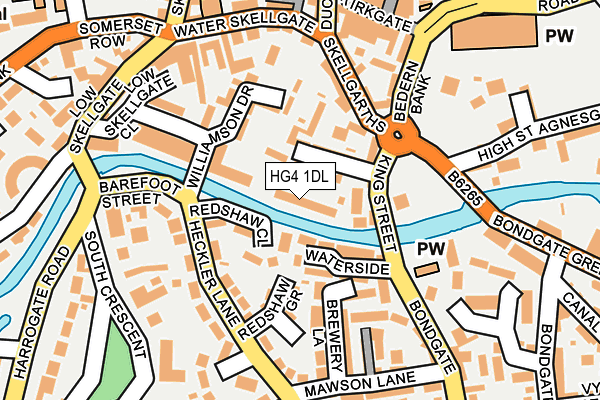
HG4 1DL lies on Wellington Gardens in Ripon. HG4 1DL is located in the Ripon Minster & Moorside electoral ward, within the unitary authority of North Yorkshire and the English Parliamentary constituency of Skipton and Ripon. The Sub Integrated Care Board (ICB) Location is NHS Humber and North Yorkshire ICB - 42D and the police force is North Yorkshire. This postcode has been in use since December 1999.


GetTheData
Source: OS OpenMap – Local (Ordnance Survey)
Source: OS VectorMap District (Ordnance Survey)
Licence: Open Government Licence (requires attribution)
| Easting | 431252 |
| Northing | 470958 |
| Latitude | 54.133524 |
| Longitude | -1.523207 |
GetTheData
Source: Open Postcode Geo
Licence: Open Government Licence
| Street | Wellington Gardens |
| Town/City | Ripon |
| Country | England |
| Postcode District | HG4 |
➜ See where HG4 is on a map ➜ Where is Ripon? | |
GetTheData
Source: Land Registry Price Paid Data
Licence: Open Government Licence
Elevation or altitude of HG4 1DL as distance above sea level:
| Metres | Feet | |
|---|---|---|
| Elevation | 30m | 98ft |
Elevation is measured from the approximate centre of the postcode, to the nearest point on an OS contour line from OS Terrain 50, which has contour spacing of ten vertical metres.
➜ How high above sea level am I? Find the elevation of your current position using your device's GPS.
GetTheData
Source: Open Postcode Elevation
Licence: Open Government Licence
| Ward | Ripon Minster & Moorside |
| Constituency | Skipton And Ripon |
GetTheData
Source: ONS Postcode Database
Licence: Open Government Licence
| Barefoot Street | Ripon | 158m |
| Barefoot Street | Ripon | 161m |
| Borrage Bridge (Harrogate Road) | Ripon | 222m |
| Borrage Bridge (Harrogate Road) | Ripon | 234m |
| Southgate (Southgate Avenue) | Ripon | 260m |
GetTheData
Source: NaPTAN
Licence: Open Government Licence
| Percentage of properties with Next Generation Access | 100.0% |
| Percentage of properties with Superfast Broadband | 100.0% |
| Percentage of properties with Ultrafast Broadband | 0.0% |
| Percentage of properties with Full Fibre Broadband | 0.0% |
Superfast Broadband is between 30Mbps and 300Mbps
Ultrafast Broadband is > 300Mbps
| Median download speed | 39.5Mbps |
| Average download speed | 45.5Mbps |
| Maximum download speed | 80.00Mbps |
| Median upload speed | 9.9Mbps |
| Average upload speed | 9.8Mbps |
| Maximum upload speed | 20.00Mbps |
| Percentage of properties unable to receive 2Mbps | 0.0% |
| Percentage of properties unable to receive 5Mbps | 0.0% |
| Percentage of properties unable to receive 10Mbps | 0.0% |
| Percentage of properties unable to receive 30Mbps | 0.0% |
GetTheData
Source: Ofcom
Licence: Ofcom Terms of Use (requires attribution)
Estimated total energy consumption in HG4 1DL by fuel type, 2015.
| Consumption (kWh) | 215,353 |
|---|---|
| Meter count | 22 |
| Mean (kWh/meter) | 9,789 |
| Median (kWh/meter) | 9,925 |
| Consumption (kWh) | 48,374 |
|---|---|
| Meter count | 22 |
| Mean (kWh/meter) | 2,199 |
| Median (kWh/meter) | 1,972 |
GetTheData
Source: Postcode level gas estimates: 2015 (experimental)
Source: Postcode level electricity estimates: 2015 (experimental)
Licence: Open Government Licence
GetTheData
Source: ONS Postcode Database
Licence: Open Government Licence


➜ Get more ratings from the Food Standards Agency
GetTheData
Source: Food Standards Agency
Licence: FSA terms & conditions
| Last Collection | |||
|---|---|---|---|
| Location | Mon-Fri | Sat | Distance |
| Bondgate P.o. | 18:15 | 12:00 | 309m |
| Ure Bank Terrace/Top | 17:30 | 12:30 | 1,366m |
| Lark Lane P.o. | 17:30 | 12:15 | 1,407m |
GetTheData
Source: Dracos
Licence: Creative Commons Attribution-ShareAlike
| Risk of HG4 1DL flooding from rivers and sea | Low |
| ➜ HG4 1DL flood map | |
GetTheData
Source: Open Flood Risk by Postcode
Licence: Open Government Licence
The below table lists the International Territorial Level (ITL) codes (formerly Nomenclature of Territorial Units for Statistics (NUTS) codes) and Local Administrative Units (LAU) codes for HG4 1DL:
| ITL 1 Code | Name |
|---|---|
| TLE | Yorkshire and The Humber |
| ITL 2 Code | Name |
| TLE2 | North Yorkshire |
| ITL 3 Code | Name |
| TLE22 | North Yorkshire CC |
| LAU 1 Code | Name |
| E07000165 | Harrogate |
GetTheData
Source: ONS Postcode Directory
Licence: Open Government Licence
The below table lists the Census Output Area (OA), Lower Layer Super Output Area (LSOA), and Middle Layer Super Output Area (MSOA) for HG4 1DL:
| Code | Name | |
|---|---|---|
| OA | E00141104 | |
| LSOA | E01027707 | Harrogate 004C |
| MSOA | E02005764 | Harrogate 004 |
GetTheData
Source: ONS Postcode Directory
Licence: Open Government Licence
| HG4 1PH | Wellington Street | 54m |
| HG4 1PS | Redshaw Close | 63m |
| HG4 1RA | Waterside | 71m |
| HG4 1PJ | King Street | 72m |
| HG4 1QU | Wellington Mews | 86m |
| HG4 1AY | Williamson Drive | 90m |
| HG4 1PQ | Redshaw Grove | 101m |
| HG4 1PF | Skellgarth | 116m |
| HG4 1PU | Heckler Lane | 117m |
| HG4 1BS | Bedern Court | 127m |
GetTheData
Source: Open Postcode Geo; Land Registry Price Paid Data
Licence: Open Government Licence