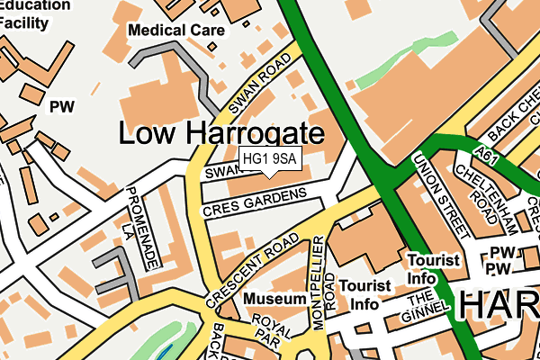
HG1 9SA is located in the Valley Gardens & Central Harrogate electoral ward, within the unitary authority of North Yorkshire and the English Parliamentary constituency of Harrogate and Knaresborough. The Sub Integrated Care Board (ICB) Location is NHS Humber and North Yorkshire ICB - 42D and the police force is North Yorkshire. This postcode has been in use since February 2005.


GetTheData
Source: OS OpenMap – Local (Ordnance Survey)
Source: OS VectorMap District (Ordnance Survey)
Licence: Open Government Licence (requires attribution)
| Easting | 429861 |
| Northing | 455518 |
| Latitude | 53.994843 |
| Longitude | -1.546009 |
GetTheData
Source: Open Postcode Geo
Licence: Open Government Licence
| Country | England |
| Postcode District | HG1 |
| ➜ HG1 open data dashboard ➜ See where HG1 is on a map ➜ Where is Harrogate? | |
GetTheData
Source: Land Registry Price Paid Data
Licence: Open Government Licence
Elevation or altitude of HG1 9SA as distance above sea level:
| Metres | Feet | |
|---|---|---|
| Elevation | 100m | 328ft |
Elevation is measured from the approximate centre of the postcode, to the nearest point on an OS contour line from OS Terrain 50, which has contour spacing of ten vertical metres.
➜ How high above sea level am I? Find the elevation of your current position using your device's GPS.
GetTheData
Source: Open Postcode Elevation
Licence: Open Government Licence
| Ward | Valley Gardens & Central Harrogate |
| Constituency | Harrogate And Knaresborough |
GetTheData
Source: ONS Postcode Database
Licence: Open Government Licence
| January 2024 | Anti-social behaviour | On or near Parking Area | 237m |
| January 2024 | Other theft | On or near Parking Area | 237m |
| December 2023 | Anti-social behaviour | On or near Swan Road | 40m |
| ➜ Get more crime data in our Crime section | |||
GetTheData
Source: data.police.uk
Licence: Open Government Licence
| Royal Hall (Montpellier Road) | West Park | 105m |
| Royal Hall (Parliament Street) | West Park | 115m |
| Cheltenham Crescent | West Park | 232m |
| White Hart (Cold Bath Road) | West Park | 253m |
| White Hart Hotel (Esplanade) | West Park | 271m |
| Harrogate Station | 0.6km |
| Hornbeam Park Station | 2.1km |
| Starbeck Station | 3km |
GetTheData
Source: NaPTAN
Licence: Open Government Licence
GetTheData
Source: ONS Postcode Database
Licence: Open Government Licence


➜ Get more ratings from the Food Standards Agency
GetTheData
Source: Food Standards Agency
Licence: FSA terms & conditions
| Last Collection | |||
|---|---|---|---|
| Location | Mon-Fri | Sat | Distance |
| 8 Royal Parade | 17:30 | 13:15 | 177m |
| York Rd/Clarence Drive | 18:15 | 13:15 | 303m |
| Harrogate P.o. | 18:30 | 12:45 | 335m |
GetTheData
Source: Dracos
Licence: Creative Commons Attribution-ShareAlike
| Facility | Distance |
|---|---|
| Advantage Health Club (Harrogate) (Closed) Ripon Road, Harrogate Health and Fitness Gym, Swimming Pool | 78m |
| The Club And Spa At The Majestic Hotel Harrogate Ripon Road, Harrogate Health and Fitness Gym, Swimming Pool, Studio, Outdoor Tennis Courts | 275m |
| Harrogate Ladies College Clarence Drive, Harrogate Grass Pitches, Sports Hall, Swimming Pool, Squash Courts, Health and Fitness Gym, Outdoor Tennis Courts | 360m |
GetTheData
Source: Active Places
Licence: Open Government Licence
| School | Phase of Education | Distance |
|---|---|---|
| Harrogate Language Academy 8a Royal Parade, Harrogate, HG1 2SZ | Not applicable | 191m |
| Harrogate Ladies' College Clarence Drive, Harrogate, HG1 2QG | Not applicable | 363m |
| Western Primary School Cold Bath Road, Harrogate, HG2 0NA | Primary | 570m |
GetTheData
Source: Edubase
Licence: Open Government Licence
The below table lists the International Territorial Level (ITL) codes (formerly Nomenclature of Territorial Units for Statistics (NUTS) codes) and Local Administrative Units (LAU) codes for HG1 9SA:
| ITL 1 Code | Name |
|---|---|
| TLE | Yorkshire and The Humber |
| ITL 2 Code | Name |
| TLE2 | North Yorkshire |
| ITL 3 Code | Name |
| TLE22 | North Yorkshire CC |
| LAU 1 Code | Name |
| E07000165 | Harrogate |
GetTheData
Source: ONS Postcode Directory
Licence: Open Government Licence
The below table lists the Census Output Area (OA), Lower Layer Super Output Area (LSOA), and Middle Layer Super Output Area (MSOA) for HG1 9SA:
| Code | Name | |
|---|---|---|
| OA | E00140961 | |
| LSOA | E01027678 | Harrogate 015E |
| MSOA | E02005775 | Harrogate 015 |
GetTheData
Source: ONS Postcode Directory
Licence: Open Government Licence
| HG1 2SW | Swan Road | 54m |
| HG1 2SB | Swan Road | 55m |
| HG1 2RT | Crescent Road | 85m |
| HG1 2SA | Swan Road | 102m |
| HG1 2SS | Swan Road | 134m |
| HG1 2EG | Montpellier Road | 148m |
| HG1 2PH | Promenade Square | 159m |
| HG1 2RL | Parliament Street | 169m |
| HG1 1BT | Kings Road | 182m |
| HG1 2PJ | Promenade Square | 184m |
GetTheData
Source: Open Postcode Geo; Land Registry Price Paid Data
Licence: Open Government Licence