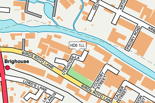
HD6 1LL is located in the Rastrick electoral ward, within the metropolitan district of Calderdale and the English Parliamentary constituency of Calder Valley. The Sub Integrated Care Board (ICB) Location is NHS West Yorkshire ICB - 02T and the police force is West Yorkshire. This postcode has been in use since January 1980.


GetTheData
Source: OS OpenMap – Local (Ordnance Survey)
Source: OS VectorMap District (Ordnance Survey)
Licence: Open Government Licence (requires attribution)
| Easting | 414991 |
| Northing | 422482 |
| Latitude | 53.698579 |
| Longitude | -1.774426 |
GetTheData
Source: Open Postcode Geo
Licence: Open Government Licence
| Country | England |
| Postcode District | HD6 |
➜ See where HD6 is on a map ➜ Where is Brighouse? | |
GetTheData
Source: Land Registry Price Paid Data
Licence: Open Government Licence
Elevation or altitude of HD6 1LL as distance above sea level:
| Metres | Feet | |
|---|---|---|
| Elevation | 60m | 197ft |
Elevation is measured from the approximate centre of the postcode, to the nearest point on an OS contour line from OS Terrain 50, which has contour spacing of ten vertical metres.
➜ How high above sea level am I? Find the elevation of your current position using your device's GPS.
GetTheData
Source: Open Postcode Elevation
Licence: Open Government Licence
| Ward | Rastrick |
| Constituency | Calder Valley |
GetTheData
Source: ONS Postcode Database
Licence: Open Government Licence
| Birds Royd Lane Foundry St (Birds Royd Lane) | Brighouse | 149m |
| Birds Royd Lane Bradford Rd (Birds Royd Lane) | Brighouse | 162m |
| Birds Royd Lane Foundry St (Birds Royd Lane) | Brighouse | 166m |
| Birds Royd Lane Bradford Rd (Birds Royd Lane) | Brighouse | 169m |
| Huddersfield Road Railway Station (Huddersfield Road) | Brighouse | 310m |
| Brighouse Station | 0.3km |
| Deighton Station | 3.7km |
GetTheData
Source: NaPTAN
Licence: Open Government Licence
Estimated total energy consumption in HD6 1LL by fuel type, 2015.
| Consumption (kWh) | 92,809 |
|---|---|
| Meter count | 8 |
| Mean (kWh/meter) | 11,601 |
| Median (kWh/meter) | 140 |
GetTheData
Source: Postcode level gas estimates: 2015 (experimental)
Source: Postcode level electricity estimates: 2015 (experimental)
Licence: Open Government Licence
GetTheData
Source: ONS Postcode Database
Licence: Open Government Licence


➜ Get more ratings from the Food Standards Agency
GetTheData
Source: Food Standards Agency
Licence: FSA terms & conditions
| Last Collection | |||
|---|---|---|---|
| Location | Mon-Fri | Sat | Distance |
| Dyehouse Lane | 18:30 | 12:30 | 22m |
| Brighouse Do Business Box | 42m | ||
| Mill Lane Business Box | 205m | ||
GetTheData
Source: Dracos
Licence: Creative Commons Attribution-ShareAlike
| Risk of HD6 1LL flooding from rivers and sea | Medium |
| ➜ HD6 1LL flood map | |
GetTheData
Source: Open Flood Risk by Postcode
Licence: Open Government Licence
The below table lists the International Territorial Level (ITL) codes (formerly Nomenclature of Territorial Units for Statistics (NUTS) codes) and Local Administrative Units (LAU) codes for HD6 1LL:
| ITL 1 Code | Name |
|---|---|
| TLE | Yorkshire and The Humber |
| ITL 2 Code | Name |
| TLE4 | West Yorkshire |
| ITL 3 Code | Name |
| TLE44 | Calderdale and Kirklees |
| LAU 1 Code | Name |
| E08000033 | Calderdale |
GetTheData
Source: ONS Postcode Directory
Licence: Open Government Licence
The below table lists the Census Output Area (OA), Lower Layer Super Output Area (LSOA), and Middle Layer Super Output Area (MSOA) for HD6 1LL:
| Code | Name | |
|---|---|---|
| OA | E00055207 | |
| LSOA | E01010949 | Calderdale 019E |
| MSOA | E02002262 | Calderdale 019 |
GetTheData
Source: ONS Postcode Directory
Licence: Open Government Licence
| HD6 1LQ | Birds Royd Lane | 149m |
| HD6 1PY | Arthur Street | 188m |
| HD6 1PT | Armytage Road | 196m |
| HD6 3RG | Lower Newlands | 229m |
| HD6 1LZ | Calder Street | 229m |
| HD6 3RE | Crossley Street | 242m |
| HD6 1ND | Woodland Square | 242m |
| HD6 3RF | Lords Lane | 247m |
| HD6 1LY | River Street | 253m |
| HD6 1PN | Mill Lane | 257m |
GetTheData
Source: Open Postcode Geo; Land Registry Price Paid Data
Licence: Open Government Licence