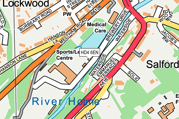
HD4 6EN lies on Brewery Drive in Huddersfield. HD4 6EN is located in the Crosland Moor and Netherton electoral ward, within the metropolitan district of Kirklees and the English Parliamentary constituency of Colne Valley. The Sub Integrated Care Board (ICB) Location is NHS West Yorkshire ICB - X2C4Y and the police force is West Yorkshire. This postcode has been in use since January 1980.


GetTheData
Source: OS OpenMap – Local (Ordnance Survey)
Source: OS VectorMap District (Ordnance Survey)
Licence: Open Government Licence (requires attribution)
| Easting | 413400 |
| Northing | 414916 |
| Latitude | 53.630618 |
| Longitude | -1.798845 |
GetTheData
Source: Open Postcode Geo
Licence: Open Government Licence
| Street | Brewery Drive |
| Town/City | Huddersfield |
| Country | England |
| Postcode District | HD4 |
➜ See where HD4 is on a map ➜ Where is Huddersfield? | |
GetTheData
Source: Land Registry Price Paid Data
Licence: Open Government Licence
Elevation or altitude of HD4 6EN as distance above sea level:
| Metres | Feet | |
|---|---|---|
| Elevation | 80m | 262ft |
Elevation is measured from the approximate centre of the postcode, to the nearest point on an OS contour line from OS Terrain 50, which has contour spacing of ten vertical metres.
➜ How high above sea level am I? Find the elevation of your current position using your device's GPS.
GetTheData
Source: Open Postcode Elevation
Licence: Open Government Licence
| Ward | Crosland Moor And Netherton |
| Constituency | Colne Valley |
GetTheData
Source: ONS Postcode Database
Licence: Open Government Licence
2, BREWERY DRIVE, HUDDERSFIELD, HD4 6EN 2009 11 AUG £65,000 |
2, BREWERY DRIVE, HUDDERSFIELD, HD4 6EN 2004 5 JAN £61,000 |
GetTheData
Source: HM Land Registry Price Paid Data
Licence: Contains HM Land Registry data © Crown copyright and database right 2025. This data is licensed under the Open Government Licence v3.0.
| Meltham Rd Bentley Street (Meltham Road) | Lockwood | 161m |
| Meltham Rd Railway Bridge (Meltham Road) | Lockwood | 161m |
| Meltham Rd Railway Bridge (Meltham Road) | Lockwood | 174m |
| Woodhead Rd Taylor Hill Road (Woodhead Road) | Lockwood | 215m |
| Woodhead Rd Taylor Hill Road (Woodhead Road) | Lockwood | 221m |
| Lockwood Station | 0.5km |
| Berry Brow Station | 1.1km |
| Huddersfield Station | 2.2km |
GetTheData
Source: NaPTAN
Licence: Open Government Licence
| Percentage of properties with Next Generation Access | 100.0% |
| Percentage of properties with Superfast Broadband | 100.0% |
| Percentage of properties with Ultrafast Broadband | 0.0% |
| Percentage of properties with Full Fibre Broadband | 0.0% |
Superfast Broadband is between 30Mbps and 300Mbps
Ultrafast Broadband is > 300Mbps
| Percentage of properties unable to receive 2Mbps | 0.0% |
| Percentage of properties unable to receive 5Mbps | 0.0% |
| Percentage of properties unable to receive 10Mbps | 0.0% |
| Percentage of properties unable to receive 30Mbps | 0.0% |
GetTheData
Source: Ofcom
Licence: Ofcom Terms of Use (requires attribution)
GetTheData
Source: ONS Postcode Database
Licence: Open Government Licence


➜ Get more ratings from the Food Standards Agency
GetTheData
Source: Food Standards Agency
Licence: FSA terms & conditions
| Last Collection | |||
|---|---|---|---|
| Location | Mon-Fri | Sat | Distance |
| Lockwood P.o. Box | 18:30 | 11:45 | 424m |
| Newsome P.o. Box | 17:15 | 12:00 | 1,045m |
| Plantation Drive | 17:15 | 12:15 | 1,081m |
GetTheData
Source: Dracos
Licence: Creative Commons Attribution-ShareAlike
| Risk of HD4 6EN flooding from rivers and sea | Medium |
| ➜ HD4 6EN flood map | |
GetTheData
Source: Open Flood Risk by Postcode
Licence: Open Government Licence
The below table lists the International Territorial Level (ITL) codes (formerly Nomenclature of Territorial Units for Statistics (NUTS) codes) and Local Administrative Units (LAU) codes for HD4 6EN:
| ITL 1 Code | Name |
|---|---|
| TLE | Yorkshire and The Humber |
| ITL 2 Code | Name |
| TLE4 | West Yorkshire |
| ITL 3 Code | Name |
| TLE44 | Calderdale and Kirklees |
| LAU 1 Code | Name |
| E08000034 | Kirklees |
GetTheData
Source: ONS Postcode Directory
Licence: Open Government Licence
The below table lists the Census Output Area (OA), Lower Layer Super Output Area (LSOA), and Middle Layer Super Output Area (MSOA) for HD4 6EN:
| Code | Name | |
|---|---|---|
| OA | E00055849 | |
| LSOA | E01011081 | Kirklees 043B |
| MSOA | E02002313 | Kirklees 043 |
GetTheData
Source: ONS Postcode Directory
Licence: Open Government Licence
| HD1 3UW | Hanson Lane | 103m |
| HD1 3UP | Meltham Road | 143m |
| HD4 6EU | Woodhead Road | 167m |
| HD4 6HR | Taylor Hill Road | 170m |
| HD4 6HS | Emmanuel Terrace | 170m |
| HD4 5HW | Thornfield Close | 175m |
| HD4 6ET | Woodhead Road | 185m |
| HD1 3UN | Burbeary Road | 189m |
| HD1 3UL | Bentley Street | 193m |
| HD4 5HR | Stone Gate Court | 205m |
GetTheData
Source: Open Postcode Geo; Land Registry Price Paid Data
Licence: Open Government Licence