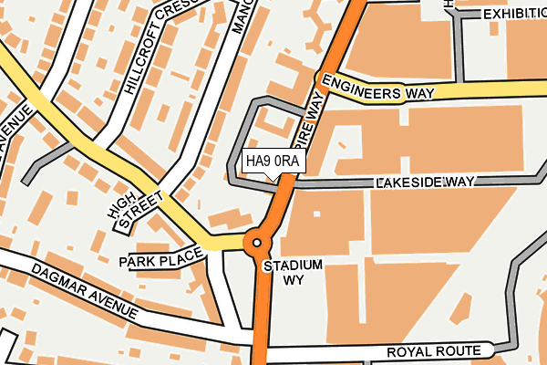
HA9 0RA is located in the Wembley Hill electoral ward, within the London borough of Brent and the English Parliamentary constituency of Brent Central. The Sub Integrated Care Board (ICB) Location is NHS North West London ICB - W2U3Z and the police force is Metropolitan Police. This postcode has been in use since January 1980.


GetTheData
Source: OS OpenMap – Local (Ordnance Survey)
Source: OS VectorMap District (Ordnance Survey)
Licence: Open Government Licence (requires attribution)
| Easting | 518931 |
| Northing | 185706 |
| Latitude | 51.557708 |
| Longitude | -0.285831 |
GetTheData
Source: Open Postcode Geo
Licence: Open Government Licence
| Country | England |
| Postcode District | HA9 |
| ➜ HA9 open data dashboard ➜ See where HA9 is on a map ➜ Where is Wembley? | |
GetTheData
Source: Land Registry Price Paid Data
Licence: Open Government Licence
Elevation or altitude of HA9 0RA as distance above sea level:
| Metres | Feet | |
|---|---|---|
| Elevation | 50m | 164ft |
Elevation is measured from the approximate centre of the postcode, to the nearest point on an OS contour line from OS Terrain 50, which has contour spacing of ten vertical metres.
➜ How high above sea level am I? Find the elevation of your current position using your device's GPS.
GetTheData
Source: Open Postcode Elevation
Licence: Open Government Licence
| Ward | Wembley Hill |
| Constituency | Brent Central |
GetTheData
Source: ONS Postcode Database
Licence: Open Government Licence
| January 2024 | Anti-social behaviour | On or near Conference/Exhibition Centre | 161m |
| January 2024 | Other theft | On or near Parking Area | 283m |
| January 2024 | Robbery | On or near Parking Area | 283m |
| ➜ Get more crime data in our Crime section | |||
GetTheData
Source: data.police.uk
Licence: Open Government Licence
| Lakeside Way | Wembley Park | 16m |
| Lakeside Way (Empire Way) | Wembley Park | 35m |
| Wembley Arena | Wembley Park | 207m |
| Wembley Arena (Engineers Way) | Wembley Park | 221m |
| Wembley Arena (Engineers Way) | Wembley Park | 228m |
| Wembley Park Underground Station | Wembley Park | 762m |
| Wembley Central Underground Station | Wembley | 972m |
| North Wembley Underground Station | North Wembley | 1,370m |
| Wembley Stadium Station | 0.4km |
| Wembley Central Station | 0.9km |
| North Wembley Station | 1.4km |
GetTheData
Source: NaPTAN
Licence: Open Government Licence
GetTheData
Source: ONS Postcode Database
Licence: Open Government Licence


➜ Get more ratings from the Food Standards Agency
GetTheData
Source: Food Standards Agency
Licence: FSA terms & conditions
| Last Collection | |||
|---|---|---|---|
| Location | Mon-Fri | Sat | Distance |
| Wembley Hill Road | 17:15 | 12:30 | 178m |
| Empire Way | 17:00 | 12:45 | 218m |
| Manor Drive | 17:00 | 12:15 | 415m |
GetTheData
Source: Dracos
Licence: Creative Commons Attribution-ShareAlike
| Facility | Distance |
|---|---|
| Spirit Health Club (Wembley) Empire Way, Wembley Swimming Pool, Health and Fitness Gym | 228m |
| Livingwell Health Club (London Wembley) Lakeside Way, Wembley Health and Fitness Gym, Swimming Pool | 240m |
| The Gym Group (London Wembley Park) Empire Way, Wembley Health and Fitness Gym, Studio | 300m |
GetTheData
Source: Active Places
Licence: Open Government Licence
| School | Phase of Education | Distance |
|---|---|---|
| St Christopher's Prep School 71 Wembley Park Drive, Wembley, HA9 8HE | Not applicable | 463m |
| New Level Academy Pendolino Way, Wembley, London, NW10 0RP | Not applicable | 511m |
| Park Lane Primary School Park Lane, Wembley, HA9 7RY | Primary | 596m |
GetTheData
Source: Edubase
Licence: Open Government Licence
The below table lists the International Territorial Level (ITL) codes (formerly Nomenclature of Territorial Units for Statistics (NUTS) codes) and Local Administrative Units (LAU) codes for HA9 0RA:
| ITL 1 Code | Name |
|---|---|
| TLI | London |
| ITL 2 Code | Name |
| TLI7 | Outer London - West and North West |
| ITL 3 Code | Name |
| TLI72 | Brent |
| LAU 1 Code | Name |
| E09000005 | Brent |
GetTheData
Source: ONS Postcode Directory
Licence: Open Government Licence
The below table lists the Census Output Area (OA), Lower Layer Super Output Area (LSOA), and Middle Layer Super Output Area (MSOA) for HA9 0RA:
| Code | Name | |
|---|---|---|
| OA | E00174551 | |
| LSOA | E01033424 | Brent 017F |
| MSOA | E02000109 | Brent 017 |
GetTheData
Source: ONS Postcode Directory
Licence: Open Government Licence
| HA9 0QZ | Empire Way | 17m |
| HA9 0QY | Empire Way | 39m |
| HA9 0RJ | Empire Way | 58m |
| HA9 0QX | Empire Way | 60m |
| HA9 0BY | Empire Way | 66m |
| HA9 0EQ | Empire Way | 66m |
| HA9 0EY | Empire Way | 66m |
| HA9 0AB | Empire Way | 91m |
| HA9 0HJ | Empire Way | 91m |
| HA9 0HL | Empire Way | 91m |
GetTheData
Source: Open Postcode Geo; Land Registry Price Paid Data
Licence: Open Government Licence