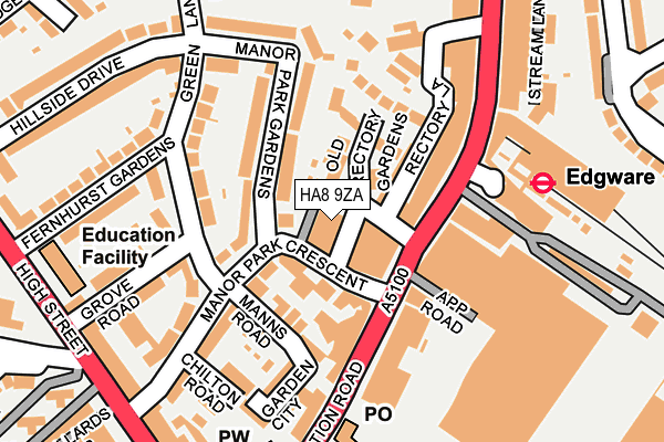
HA8 9ZA is located in the Edgware electoral ward, within the London borough of Barnet and the English Parliamentary constituency of Hendon. The Sub Integrated Care Board (ICB) Location is NHS North Central London ICB - 93C and the police force is Metropolitan Police. This postcode has been in use since September 2015.


GetTheData
Source: OS OpenMap – Local (Ordnance Survey)
Source: OS VectorMap District (Ordnance Survey)
Licence: Open Government Licence (requires attribution)
| Easting | 519342 |
| Northing | 191905 |
| Latitude | 51.613334 |
| Longitude | -0.277800 |
GetTheData
Source: Open Postcode Geo
Licence: Open Government Licence
| Country | England |
| Postcode District | HA8 |
| ➜ HA8 open data dashboard ➜ See where HA8 is on a map | |
GetTheData
Source: Land Registry Price Paid Data
Licence: Open Government Licence
Elevation or altitude of HA8 9ZA as distance above sea level:
| Metres | Feet | |
|---|---|---|
| Elevation | 60m | 197ft |
Elevation is measured from the approximate centre of the postcode, to the nearest point on an OS contour line from OS Terrain 50, which has contour spacing of ten vertical metres.
➜ How high above sea level am I? Find the elevation of your current position using your device's GPS.
GetTheData
Source: Open Postcode Elevation
Licence: Open Government Licence
| Ward | Edgware |
| Constituency | Hendon |
GetTheData
Source: ONS Postcode Database
Licence: Open Government Licence
| January 2024 | Violence and sexual offences | On or near Manor Park Gardens | 86m |
| January 2024 | Violence and sexual offences | On or near Manor Park Gardens | 86m |
| January 2024 | Burglary | On or near Forumside | 321m |
| ➜ Get more crime data in our Crime section | |||
GetTheData
Source: data.police.uk
Licence: Open Government Licence
| Manor Park Crescent (Station Road) | Edgware | 106m |
| Manor Park Crescent (Station Road) | Edgware | 142m |
| Edgware | Edgware | 158m |
| Edgware Station Station Road (Station Road) | Edgware | 191m |
| Edgware | Edgware | 202m |
| Edgware Underground Station | Edgware | 202m |
| Canons Park Underground Station | Canons Park | 1,327m |
| Burnt Oak Underground Station | Burnt Oak | 1,512m |
| Mill Hill Broadway Station | 2km |
| Elstree & Borehamwood Station | 4.4km |
| Kenton Station | 4.4km |
GetTheData
Source: NaPTAN
Licence: Open Government Licence
GetTheData
Source: ONS Postcode Database
Licence: Open Government Licence


➜ Get more ratings from the Food Standards Agency
GetTheData
Source: Food Standards Agency
Licence: FSA terms & conditions
| Last Collection | |||
|---|---|---|---|
| Location | Mon-Fri | Sat | Distance |
| Edgware Post Office | 18:30 | 12:00 | 184m |
| Hemming Road | 18:15 | 12:00 | 444m |
| Sonia Court | 17:30 | 12:00 | 796m |
GetTheData
Source: Dracos
Licence: Creative Commons Attribution-ShareAlike
| Facility | Distance |
|---|---|
| Puregym (London Edgware) Station Road, The Hale, Edgware Swimming Pool, Health and Fitness Gym, Studio | 44m |
| Edgware Primary School Heming Road, Edgware Grass Pitches | 387m |
| Stonegrove Park Park Grove, Edgware Outdoor Tennis Courts | 475m |
GetTheData
Source: Active Places
Licence: Open Government Licence
| School | Phase of Education | Distance |
|---|---|---|
| Tashbar of Edgware 45-47 Mowbray Road, Edgware, HA8 8JL | Not applicable | 244m |
| Edgware Jewish Girls - Beis Chinuch 296 Hale Lane, Edgware, HA8 8NP | Not applicable | 392m |
| Edgware Primary School Heming Road, Edgware, HA8 9AB | Primary | 400m |
GetTheData
Source: Edubase
Licence: Open Government Licence
The below table lists the International Territorial Level (ITL) codes (formerly Nomenclature of Territorial Units for Statistics (NUTS) codes) and Local Administrative Units (LAU) codes for HA8 9ZA:
| ITL 1 Code | Name |
|---|---|
| TLI | London |
| ITL 2 Code | Name |
| TLI7 | Outer London - West and North West |
| ITL 3 Code | Name |
| TLI71 | Barnet |
| LAU 1 Code | Name |
| E09000003 | Barnet |
GetTheData
Source: ONS Postcode Directory
Licence: Open Government Licence
The below table lists the Census Output Area (OA), Lower Layer Super Output Area (LSOA), and Middle Layer Super Output Area (MSOA) for HA8 9ZA:
| Code | Name | |
|---|---|---|
| OA | E00000957 | |
| LSOA | E01000193 | Barnet 018B |
| MSOA | E02000041 | Barnet 018 |
GetTheData
Source: ONS Postcode Directory
Licence: Open Government Licence
| HA8 7JQ | Station Road | 44m |
| HA8 7LZ | Manor Park Crescent | 47m |
| HA8 7LF | Rectory Lane | 52m |
| HA8 7LY | Manor Park Crescent | 53m |
| HA8 7NE | Manor Park Crescent | 86m |
| HA8 7LS | Old Rectory Gardens | 89m |
| HA8 7NG | Manns Road | 93m |
| HA8 7NF | Manns Road | 95m |
| HA8 7NB | Manor Park Gardens | 108m |
| HA8 7JG | Station Road | 108m |
GetTheData
Source: Open Postcode Geo; Land Registry Price Paid Data
Licence: Open Government Licence