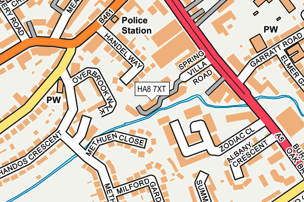
HA8 7XT is located in the Edgware electoral ward, within the London borough of Harrow and the English Parliamentary constituency of Harrow East. The Sub Integrated Care Board (ICB) Location is NHS North West London ICB - W2U3Z and the police force is Metropolitan Police. This postcode has been in use since December 1996.


GetTheData
Source: OS OpenMap – Local (Ordnance Survey)
Source: OS VectorMap District (Ordnance Survey)
Licence: Open Government Licence (requires attribution)
| Easting | 519247 |
| Northing | 191358 |
| Latitude | 51.608438 |
| Longitude | -0.279357 |
GetTheData
Source: Open Postcode Geo
Licence: Open Government Licence
| Country | England |
| Postcode District | HA8 |
➜ See where HA8 is on a map ➜ Where is Stanmore? | |
GetTheData
Source: Land Registry Price Paid Data
Licence: Open Government Licence
Elevation or altitude of HA8 7XT as distance above sea level:
| Metres | Feet | |
|---|---|---|
| Elevation | 60m | 197ft |
Elevation is measured from the approximate centre of the postcode, to the nearest point on an OS contour line from OS Terrain 50, which has contour spacing of ten vertical metres.
➜ How high above sea level am I? Find the elevation of your current position using your device's GPS.
GetTheData
Source: Open Postcode Elevation
Licence: Open Government Licence
| Ward | Edgware |
| Constituency | Harrow East |
GetTheData
Source: ONS Postcode Database
Licence: Open Government Licence
| Springvilla Road (Edgware High Street) | Little Stanmore | 164m |
| Edgware Police Station (Whitchurch Lane) | Little Stanmore | 191m |
| Whitchurch Lane (Edgware High Street) | Edgware | 208m |
| Buckingham Road (Ha8) | Little Stanmore | 251m |
| Deansbrook Road (Edgware High Street) | Edgware | 272m |
| Edgware Underground Station | Edgware | 656m |
| Canons Park Underground Station | Canons Park | 1,065m |
| Burnt Oak Underground Station | Burnt Oak | 1,234m |
| Mill Hill Broadway Station | 2.1km |
| Kenton Station | 3.9km |
| Hendon Station | 4.2km |
GetTheData
Source: NaPTAN
Licence: Open Government Licence
GetTheData
Source: ONS Postcode Database
Licence: Open Government Licence


➜ Get more ratings from the Food Standards Agency
GetTheData
Source: Food Standards Agency
Licence: FSA terms & conditions
| Last Collection | |||
|---|---|---|---|
| Location | Mon-Fri | Sat | Distance |
| Camrose Avenue | 18:15 | 12:00 | 361m |
| Hemming Road | 18:15 | 12:00 | 370m |
| Edgware Post Office | 18:30 | 12:00 | 377m |
GetTheData
Source: Dracos
Licence: Creative Commons Attribution-ShareAlike
| Risk of HA8 7XT flooding from rivers and sea | Low |
| ➜ HA8 7XT flood map | |
GetTheData
Source: Open Flood Risk by Postcode
Licence: Open Government Licence
The below table lists the International Territorial Level (ITL) codes (formerly Nomenclature of Territorial Units for Statistics (NUTS) codes) and Local Administrative Units (LAU) codes for HA8 7XT:
| ITL 1 Code | Name |
|---|---|
| TLI | London |
| ITL 2 Code | Name |
| TLI7 | Outer London - West and North West |
| ITL 3 Code | Name |
| TLI74 | Harrow and Hillingdon |
| LAU 1 Code | Name |
| E09000015 | Harrow |
GetTheData
Source: ONS Postcode Directory
Licence: Open Government Licence
The below table lists the Census Output Area (OA), Lower Layer Super Output Area (LSOA), and Middle Layer Super Output Area (MSOA) for HA8 7XT:
| Code | Name | |
|---|---|---|
| OA | E00010648 | |
| LSOA | E01002119 | Harrow 007A |
| MSOA | E02000439 | Harrow 007 |
GetTheData
Source: ONS Postcode Directory
Licence: Open Government Licence
| HA8 5FH | Zodiac Close | 44m |
| HA8 6LF | Handel Way | 59m |
| HA8 5FG | Zodiac Close | 75m |
| HA8 5FJ | Zodiac Close | 83m |
| HA8 6HA | Methuen Close | 102m |
| HA8 6LG | Handel Way | 105m |
| HA8 5FN | Zodiac Close | 108m |
| HA8 6JW | Overbrook Walk | 116m |
| HA8 5FF | Zodiac Close | 116m |
| HA8 5FL | Zodiac Close | 121m |
GetTheData
Source: Open Postcode Geo; Land Registry Price Paid Data
Licence: Open Government Licence