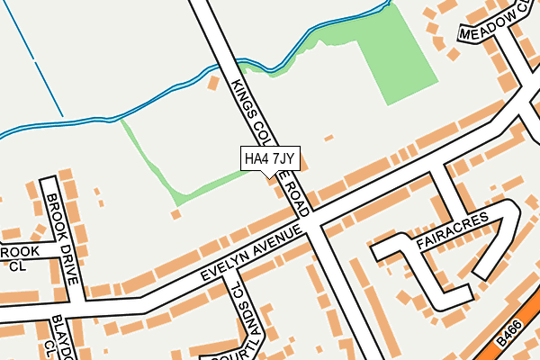
HA4 7JY lies on Kings College Road in Ruislip. HA4 7JY is located in the Ruislip electoral ward, within the London borough of Hillingdon and the English Parliamentary constituency of Ruislip, Northwood and Pinner. The Sub Integrated Care Board (ICB) Location is NHS North West London ICB - W2U3Z and the police force is Metropolitan Police. This postcode has been in use since January 1980.


GetTheData
Source: OS OpenMap – Local (Ordnance Survey)
Source: OS VectorMap District (Ordnance Survey)
Licence: Open Government Licence (requires attribution)
| Easting | 509681 |
| Northing | 188021 |
| Latitude | 51.580388 |
| Longitude | -0.418482 |
GetTheData
Source: Open Postcode Geo
Licence: Open Government Licence
| Street | Kings College Road |
| Town/City | Ruislip |
| Country | England |
| Postcode District | HA4 |
➜ See where HA4 is on a map ➜ Where is Ruislip? | |
GetTheData
Source: Land Registry Price Paid Data
Licence: Open Government Licence
Elevation or altitude of HA4 7JY as distance above sea level:
| Metres | Feet | |
|---|---|---|
| Elevation | 50m | 164ft |
Elevation is measured from the approximate centre of the postcode, to the nearest point on an OS contour line from OS Terrain 50, which has contour spacing of ten vertical metres.
➜ How high above sea level am I? Find the elevation of your current position using your device's GPS.
GetTheData
Source: Open Postcode Elevation
Licence: Open Government Licence
| Ward | Ruislip |
| Constituency | Ruislip, Northwood And Pinner |
GetTheData
Source: ONS Postcode Database
Licence: Open Government Licence
2013 13 DEC £570,000 |
2007 30 APR £490,000 |
1999 5 NOV £283,000 |
GetTheData
Source: HM Land Registry Price Paid Data
Licence: Contains HM Land Registry data © Crown copyright and database right 2025. This data is licensed under the Open Government Licence v3.0.
| West Hatch Manor (Windmill Hill) | Ruislip | 359m |
| West Hatch Manor (Windmill Hill) | Ruislip | 379m |
| Hume Way (Eastcote Road) | Eastcote Village | 418m |
| Hume Way (Eastcote Road) | Eastcote Village | 447m |
| Hume Way | Eastcote Village | 609m |
| Ruislip Manor Underground Station | Ruislip Manor | 886m |
| Ruislip Underground Station | Ruislip | 1,033m |
| Woody Bay (Ruislip Lido Railway) (Ruislip Lido) | Ruislip Common | 1,165m |
| Eastcote Underground Station | Eastcote | 1,525m |
| Willow Lawn (Ruislip Lido Railway) (Ruislip Lido) | Ruislip Common | 1,587m |
| West Ruislip Station | 1.8km |
| South Ruislip Station | 2.9km |
| Hatch End Station | 4.7km |
GetTheData
Source: NaPTAN
Licence: Open Government Licence
| Percentage of properties with Next Generation Access | 100.0% |
| Percentage of properties with Superfast Broadband | 100.0% |
| Percentage of properties with Ultrafast Broadband | 100.0% |
| Percentage of properties with Full Fibre Broadband | 0.0% |
Superfast Broadband is between 30Mbps and 300Mbps
Ultrafast Broadband is > 300Mbps
| Percentage of properties unable to receive 2Mbps | 0.0% |
| Percentage of properties unable to receive 5Mbps | 0.0% |
| Percentage of properties unable to receive 10Mbps | 0.0% |
| Percentage of properties unable to receive 30Mbps | 0.0% |
GetTheData
Source: Ofcom
Licence: Ofcom Terms of Use (requires attribution)
GetTheData
Source: ONS Postcode Database
Licence: Open Government Licence


➜ Get more ratings from the Food Standards Agency
GetTheData
Source: Food Standards Agency
Licence: FSA terms & conditions
| Last Collection | |||
|---|---|---|---|
| Location | Mon-Fri | Sat | Distance |
| Evelyn Avenue | 18:15 | 12:45 | 197m |
| Kings College Road | 18:15 | 12:45 | 365m |
| Evelyn Avenue | 18:15 | 12:45 | 445m |
GetTheData
Source: Dracos
Licence: Creative Commons Attribution-ShareAlike
| Risk of HA4 7JY flooding from rivers and sea | Low |
| ➜ HA4 7JY flood map | |
GetTheData
Source: Open Flood Risk by Postcode
Licence: Open Government Licence
The below table lists the International Territorial Level (ITL) codes (formerly Nomenclature of Territorial Units for Statistics (NUTS) codes) and Local Administrative Units (LAU) codes for HA4 7JY:
| ITL 1 Code | Name |
|---|---|
| TLI | London |
| ITL 2 Code | Name |
| TLI7 | Outer London - West and North West |
| ITL 3 Code | Name |
| TLI74 | Harrow and Hillingdon |
| LAU 1 Code | Name |
| E09000017 | Hillingdon |
GetTheData
Source: ONS Postcode Directory
Licence: Open Government Licence
The below table lists the Census Output Area (OA), Lower Layer Super Output Area (LSOA), and Middle Layer Super Output Area (MSOA) for HA4 7JY:
| Code | Name | |
|---|---|---|
| OA | E00012122 | |
| LSOA | E01002430 | Hillingdon 007A |
| MSOA | E02000500 | Hillingdon 007 |
GetTheData
Source: ONS Postcode Directory
Licence: Open Government Licence
| HA4 8AQ | Evelyn Avenue | 118m |
| HA4 8AL | Evelyn Avenue | 124m |
| HA4 8AJ | Evelyn Avenue | 151m |
| HA4 8AH | Evelyn Avenue | 153m |
| HA4 8AW | Fairacres | 168m |
| HA4 8BQ | Kings College Road | 169m |
| HA4 8BH | Kings College Road | 186m |
| HA4 8AX | Courtlands Close | 191m |
| HA4 8AG | Brook Drive | 227m |
| HA4 8AN | Fairacres | 246m |
GetTheData
Source: Open Postcode Geo; Land Registry Price Paid Data
Licence: Open Government Licence