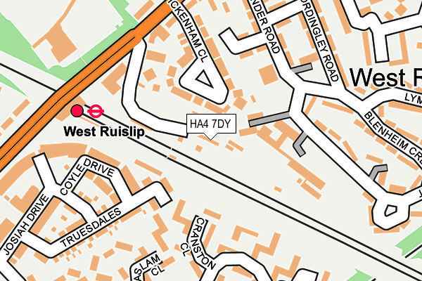
HA4 7DY is located in the Ruislip electoral ward, within the London borough of Hillingdon and the English Parliamentary constituency of Ruislip, Northwood and Pinner. The Sub Integrated Care Board (ICB) Location is NHS North West London ICB - W2U3Z and the police force is Metropolitan Police. This postcode has been in use since January 1980.


GetTheData
Source: OS OpenMap – Local (Ordnance Survey)
Source: OS VectorMap District (Ordnance Survey)
Licence: Open Government Licence (requires attribution)
| Easting | 508569 |
| Northing | 186754 |
| Latitude | 51.569217 |
| Longitude | -0.434894 |
GetTheData
Source: Open Postcode Geo
Licence: Open Government Licence
| Country | England |
| Postcode District | HA4 |
| ➜ HA4 open data dashboard ➜ See where HA4 is on a map ➜ Where is Ruislip? | |
GetTheData
Source: Land Registry Price Paid Data
Licence: Open Government Licence
Elevation or altitude of HA4 7DY as distance above sea level:
| Metres | Feet | |
|---|---|---|
| Elevation | 50m | 164ft |
Elevation is measured from the approximate centre of the postcode, to the nearest point on an OS contour line from OS Terrain 50, which has contour spacing of ten vertical metres.
➜ How high above sea level am I? Find the elevation of your current position using your device's GPS.
GetTheData
Source: Open Postcode Elevation
Licence: Open Government Licence
| Ward | Ruislip |
| Constituency | Ruislip, Northwood And Pinner |
GetTheData
Source: ONS Postcode Database
Licence: Open Government Licence
| January 2024 | Violence and sexual offences | On or near Aylsham Drive | 245m |
| January 2024 | Vehicle crime | On or near Ickenham Road | 410m |
| January 2024 | Vehicle crime | On or near Ickenham Road | 410m |
| ➜ Get more crime data in our Crime section | |||
GetTheData
Source: data.police.uk
Licence: Open Government Licence
| West Ruislip | West Ruislip | 211m |
| West Ruislip | West Ruislip | 224m |
| Sharps Lane Ickenham Road | West Ruislip | 319m |
| Sharps Lane Ickenham Road | West Ruislip | 353m |
| Church Avenue | West Ruislip | 447m |
| West Ruislip Underground Station | West Ruislip | 212m |
| Ruislip Underground Station | Ruislip | 933m |
| Ickenham Underground Station | Ickenham | 942m |
| West Ruislip Station | 0.2km |
| South Ruislip Station | 2.8km |
| Denham Station | 4.5km |
GetTheData
Source: NaPTAN
Licence: Open Government Licence
GetTheData
Source: ONS Postcode Database
Licence: Open Government Licence


➜ Get more ratings from the Food Standards Agency
GetTheData
Source: Food Standards Agency
Licence: FSA terms & conditions
| Last Collection | |||
|---|---|---|---|
| Location | Mon-Fri | Sat | Distance |
| Times House | 18:30 | 13:00 | 947m |
| Shenley Avenue | 16:45 | 12:45 | 1,005m |
| Crosier Way | 16:45 | 12:00 | 1,011m |
GetTheData
Source: Dracos
Licence: Creative Commons Attribution-ShareAlike
| Facility | Distance |
|---|---|
| Ruislip Golf Centre Ickenham Road, Ruislip Golf | 250m |
| Tweeddale Playing Fields Tweeddale Grove, Ickenham, Uxbridge Grass Pitches | 627m |
| Ruislip Rugby Football Club West End Road, Ruislip Grass Pitches | 793m |
GetTheData
Source: Active Places
Licence: Open Government Licence
| School | Phase of Education | Distance |
|---|---|---|
| Pentland Field School Pentland Way, Ickenham, Uxbridge, UB10 8TS | Not applicable | 450m |
| Sacred Heart Catholic Primary School Herlwyn Avenue, Ruislip, HA4 6EZ | Primary | 735m |
| Bishop Winnington-Ingram CofE Primary School Southcote Rise, Ruislip, HA4 7LW | Primary | 958m |
GetTheData
Source: Edubase
Licence: Open Government Licence
The below table lists the International Territorial Level (ITL) codes (formerly Nomenclature of Territorial Units for Statistics (NUTS) codes) and Local Administrative Units (LAU) codes for HA4 7DY:
| ITL 1 Code | Name |
|---|---|
| TLI | London |
| ITL 2 Code | Name |
| TLI7 | Outer London - West and North West |
| ITL 3 Code | Name |
| TLI74 | Harrow and Hillingdon |
| LAU 1 Code | Name |
| E09000017 | Hillingdon |
GetTheData
Source: ONS Postcode Directory
Licence: Open Government Licence
The below table lists the Census Output Area (OA), Lower Layer Super Output Area (LSOA), and Middle Layer Super Output Area (MSOA) for HA4 7DY:
| Code | Name | |
|---|---|---|
| OA | E00012616 | |
| LSOA | E01002537 | Hillingdon 009E |
| MSOA | E02000502 | Hillingdon 009 |
GetTheData
Source: ONS Postcode Directory
Licence: Open Government Licence
| UB10 8FP | Kenmare Close | 90m |
| UB10 8TH | Cranston Close | 103m |
| UB10 8FY | Truesdales | 108m |
| HA4 7DJ | Ickenham Close | 113m |
| UB10 8FX | Truesdales | 127m |
| UB10 8UG | Aylsham Drive | 142m |
| UB10 8FW | Coyle Drive | 158m |
| HA4 7DL | Station Parade | 165m |
| UB10 8UQ | Aylsham Drive | 165m |
| HA4 7DN | West Ruislip Court Ickenham Road | 179m |
GetTheData
Source: Open Postcode Geo; Land Registry Price Paid Data
Licence: Open Government Licence