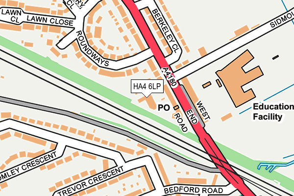
HA4 6LP is located in the Ruislip Manor electoral ward, within the London borough of Hillingdon and the English Parliamentary constituency of Uxbridge and South Ruislip. The Sub Integrated Care Board (ICB) Location is NHS North West London ICB - W2U3Z and the police force is Metropolitan Police. This postcode has been in use since January 1980.


GetTheData
Source: OS OpenMap – Local (Ordnance Survey)
Source: OS VectorMap District (Ordnance Survey)
Licence: Open Government Licence (requires attribution)
| Easting | 509992 |
| Northing | 186053 |
| Latitude | 51.562639 |
| Longitude | -0.414611 |
GetTheData
Source: Open Postcode Geo
Licence: Open Government Licence
| Country | England |
| Postcode District | HA4 |
➜ See where HA4 is on a map ➜ Where is Ruislip? | |
GetTheData
Source: Land Registry Price Paid Data
Licence: Open Government Licence
Elevation or altitude of HA4 6LP as distance above sea level:
| Metres | Feet | |
|---|---|---|
| Elevation | 40m | 131ft |
Elevation is measured from the approximate centre of the postcode, to the nearest point on an OS contour line from OS Terrain 50, which has contour spacing of ten vertical metres.
➜ How high above sea level am I? Find the elevation of your current position using your device's GPS.
GetTheData
Source: Open Postcode Elevation
Licence: Open Government Licence
| Ward | Ruislip Manor |
| Constituency | Uxbridge And South Ruislip |
GetTheData
Source: ONS Postcode Database
Licence: Open Government Licence
| Berkeley Close (West End Road) | Ruislip Gardens | 74m |
| Berkeley Close (West End Road) | Ruislip Gardens | 78m |
| Ruislip Gardens (West End Road) | Ruislip Gardens | 328m |
| Northdown Close (West End Road) | Ruislip Gardens | 369m |
| Ruislip Gardens (West End Road) | Ruislip Gardens | 373m |
| Ruislip Gardens Underground Station | Ruislip Gardens | 344m |
| Ruislip Underground Station | Ruislip | 1,093m |
| Ruislip Manor Underground Station | Ruislip Manor | 1,180m |
| South Ruislip Underground Station | South Ruislip | 1,264m |
| South Ruislip Station | 1.2km |
| West Ruislip Station | 1.8km |
| Northolt Park Station | 3.9km |
GetTheData
Source: NaPTAN
Licence: Open Government Licence
GetTheData
Source: ONS Postcode Database
Licence: Open Government Licence


➜ Get more ratings from the Food Standards Agency
GetTheData
Source: Food Standards Agency
Licence: FSA terms & conditions
| Last Collection | |||
|---|---|---|---|
| Location | Mon-Fri | Sat | Distance |
| West End Road Post Office | 17:15 | 12:00 | 66m |
| Torrington Road | 18:30 | 12:00 | 330m |
| 113 Clyford Road | 17:15 | 12:45 | 378m |
GetTheData
Source: Dracos
Licence: Creative Commons Attribution-ShareAlike
| Risk of HA4 6LP flooding from rivers and sea | Low |
| ➜ HA4 6LP flood map | |
GetTheData
Source: Open Flood Risk by Postcode
Licence: Open Government Licence
The below table lists the International Territorial Level (ITL) codes (formerly Nomenclature of Territorial Units for Statistics (NUTS) codes) and Local Administrative Units (LAU) codes for HA4 6LP:
| ITL 1 Code | Name |
|---|---|
| TLI | London |
| ITL 2 Code | Name |
| TLI7 | Outer London - West and North West |
| ITL 3 Code | Name |
| TLI74 | Harrow and Hillingdon |
| LAU 1 Code | Name |
| E09000017 | Hillingdon |
GetTheData
Source: ONS Postcode Directory
Licence: Open Government Licence
The below table lists the Census Output Area (OA), Lower Layer Super Output Area (LSOA), and Middle Layer Super Output Area (MSOA) for HA4 6LP:
| Code | Name | |
|---|---|---|
| OA | E00012307 | |
| LSOA | E01002465 | Hillingdon 009A |
| MSOA | E02000502 | Hillingdon 009 |
GetTheData
Source: ONS Postcode Directory
Licence: Open Government Licence
| HA4 6LS | West End Road | 47m |
| HA4 6DY | West End Road | 62m |
| HA4 6LR | New Pond Parade | 98m |
| HA4 6EA | Roundways | 122m |
| HA4 6NE | Trevor Crescent | 133m |
| HA4 6LF | Berkeley Close | 144m |
| HA4 6PE | Stafford Road | 146m |
| HA4 6DZ | Roundways | 151m |
| HA4 6DX | West End Road | 156m |
| HA4 6PF | Stafford Road | 162m |
GetTheData
Source: Open Postcode Geo; Land Registry Price Paid Data
Licence: Open Government Licence