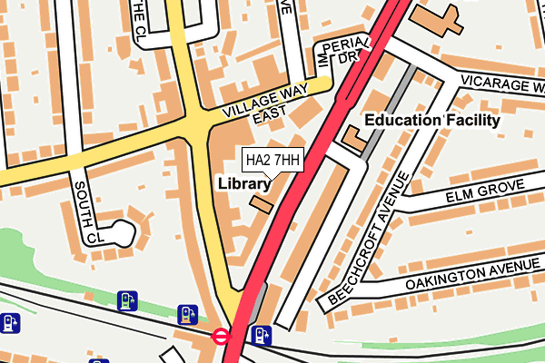
HA2 7HH is located in the Pinner South electoral ward, within the London borough of Harrow and the English Parliamentary constituency of Harrow West. The Sub Integrated Care Board (ICB) Location is NHS North West London ICB - W2U3Z and the police force is Metropolitan Police. This postcode has been in use since January 1980.


GetTheData
Source: OS OpenMap – Local (Ordnance Survey)
Source: OS VectorMap District (Ordnance Survey)
Licence: Open Government Licence (requires attribution)
| Easting | 513050 |
| Northing | 187676 |
| Latitude | 51.576622 |
| Longitude | -0.369992 |
GetTheData
Source: Open Postcode Geo
Licence: Open Government Licence
| Country | England |
| Postcode District | HA2 |
| ➜ HA2 open data dashboard ➜ See where HA2 is on a map ➜ Where is London? | |
GetTheData
Source: Land Registry Price Paid Data
Licence: Open Government Licence
Elevation or altitude of HA2 7HH as distance above sea level:
| Metres | Feet | |
|---|---|---|
| Elevation | 50m | 164ft |
Elevation is measured from the approximate centre of the postcode, to the nearest point on an OS contour line from OS Terrain 50, which has contour spacing of ten vertical metres.
➜ How high above sea level am I? Find the elevation of your current position using your device's GPS.
GetTheData
Source: Open Postcode Elevation
Licence: Open Government Licence
| Ward | Pinner South |
| Constituency | Harrow West |
GetTheData
Source: ONS Postcode Database
Licence: Open Government Licence
| January 2024 | Violence and sexual offences | On or near Rayners Lane | 100m |
| January 2024 | Anti-social behaviour | On or near Rayners Lane | 100m |
| January 2024 | Public order | On or near Rayners Lane | 100m |
| ➜ Get more crime data in our Crime section | |||
GetTheData
Source: data.police.uk
Licence: Open Government Licence
| Rayners Lane (Imperial Drive) | Rayners Lane | 61m |
| Village Way East | Rayners Lane | 94m |
| Rayners Lane | Rayners Lane | 114m |
| Rayners Lane | Rayners Lane | 118m |
| Village Way Rayners Lane (Village Way) | Rayners Lane | 132m |
| Rayners Lane Underground Station | Rayners Lane | 182m |
| North Harrow Underground Station | North Harrow | 1,057m |
| West Harrow Underground Station | West Harrow | 1,200m |
| South Harrow Underground Station | South Harrow | 1,782m |
| Northolt Park Station | 2.2km |
| Harrow-on-the-Hill Station | 2.3km |
| South Ruislip Station | 3km |
GetTheData
Source: NaPTAN
Licence: Open Government Licence
GetTheData
Source: ONS Postcode Database
Licence: Open Government Licence


➜ Get more ratings from the Food Standards Agency
GetTheData
Source: Food Standards Agency
Licence: FSA terms & conditions
| Last Collection | |||
|---|---|---|---|
| Location | Mon-Fri | Sat | Distance |
| 443 Rayners Lane | 17:30 | 13:00 | 127m |
| The Drive | 17:30 | 12:45 | 412m |
| Village Way | 17:45 | 13:00 | 511m |
GetTheData
Source: Dracos
Licence: Creative Commons Attribution-ShareAlike
| Facility | Distance |
|---|---|
| Harrow Town Sports Club Rayners Lane, Harrow Grass Pitches, Outdoor Tennis Courts | 294m |
| Longfield Primary School Dukes Avenue, North Harrow, Harrow Grass Pitches | 420m |
| Tithe Farm Sports And Social Club Rayners Lane, Harrow Grass Pitches, Artificial Grass Pitch | 770m |
GetTheData
Source: Active Places
Licence: Open Government Licence
| School | Phase of Education | Distance |
|---|---|---|
| Buckingham Preparatory School 458 Rayners Lane, Pinner, HA5 5DT | Not applicable | 308m |
| Longfield Primary School Duke's Avenue, North Harrow, Harrow, HA2 7NZ | Primary | 428m |
| Newton Farm Nursery, Infant and Junior School Ravenswood Crescent, South Harrow, Harrow, HA2 9JU | Primary | 876m |
GetTheData
Source: Edubase
Licence: Open Government Licence
The below table lists the International Territorial Level (ITL) codes (formerly Nomenclature of Territorial Units for Statistics (NUTS) codes) and Local Administrative Units (LAU) codes for HA2 7HH:
| ITL 1 Code | Name |
|---|---|
| TLI | London |
| ITL 2 Code | Name |
| TLI7 | Outer London - West and North West |
| ITL 3 Code | Name |
| TLI74 | Harrow and Hillingdon |
| LAU 1 Code | Name |
| E09000015 | Harrow |
GetTheData
Source: ONS Postcode Directory
Licence: Open Government Licence
The below table lists the Census Output Area (OA), Lower Layer Super Output Area (LSOA), and Middle Layer Super Output Area (MSOA) for HA2 7HH:
| Code | Name | |
|---|---|---|
| OA | E00011024 | |
| LSOA | E01002209 | Harrow 025B |
| MSOA | E02000457 | Harrow 025 |
GetTheData
Source: ONS Postcode Directory
Licence: Open Government Licence
| HA2 7HJ | Imperial Drive | 37m |
| HA2 7HG | Imperial Drive | 37m |
| HA5 5DY | Rayners Lane | 67m |
| HA2 7LX | Village Way East | 70m |
| HA5 5ED | Rayners Lane | 80m |
| HA5 5ER | Rayners Lane | 102m |
| HA2 7JF | Beechcroft Avenue | 105m |
| HA2 7LU | Village Way East | 108m |
| HA5 5EN | Rayners Lane | 109m |
| HA5 5DX | Rayners Lane | 128m |
GetTheData
Source: Open Postcode Geo; Land Registry Price Paid Data
Licence: Open Government Licence