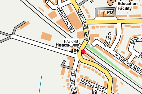
HA2 6NB is located in the Headstone electoral ward, within the London borough of Harrow and the English Parliamentary constituency of Harrow West. The Sub Integrated Care Board (ICB) Location is NHS North West London ICB - W2U3Z and the police force is Metropolitan Police. This postcode has been in use since January 1980.


GetTheData
Source: OS OpenMap – Local (Ordnance Survey)
Source: OS VectorMap District (Ordnance Survey)
Licence: Open Government Licence (requires attribution)
| Easting | 513815 |
| Northing | 190617 |
| Latitude | 51.602904 |
| Longitude | -0.357982 |
GetTheData
Source: Open Postcode Geo
Licence: Open Government Licence
| Country | England |
| Postcode District | HA2 |
| ➜ HA2 open data dashboard ➜ See where HA2 is on a map ➜ Where is London? | |
GetTheData
Source: Land Registry Price Paid Data
Licence: Open Government Licence
Elevation or altitude of HA2 6NB as distance above sea level:
| Metres | Feet | |
|---|---|---|
| Elevation | 60m | 197ft |
Elevation is measured from the approximate centre of the postcode, to the nearest point on an OS contour line from OS Terrain 50, which has contour spacing of ten vertical metres.
➜ How high above sea level am I? Find the elevation of your current position using your device's GPS.
GetTheData
Source: Open Postcode Elevation
Licence: Open Government Licence
| Ward | Headstone |
| Constituency | Harrow West |
GetTheData
Source: ONS Postcode Database
Licence: Open Government Licence
| December 2023 | Violence and sexual offences | On or near Juxon Close | 155m |
| November 2023 | Anti-social behaviour | On or near Juxon Close | 155m |
| November 2023 | Violence and sexual offences | On or near Juxon Close | 155m |
| ➜ Get more crime data in our Crime section | |||
GetTheData
Source: data.police.uk
Licence: Open Government Licence
| Headstone Lane (Long Elmes) | Harrow Weald | 131m |
| Headstone Lane Station (Headstone Lane) | Hatch End | 132m |
| Headstone Lane (Long Elmes) | Harrow Weald | 144m |
| Headstone Lane Station (Headstone Lane) | Hatch End | 157m |
| Mullion Close | Hatch End | 303m |
| Headstone Lane Station | 0.1km |
| Hatch End Station | 1km |
| Harrow & Wealdstone Station | 2km |
GetTheData
Source: NaPTAN
Licence: Open Government Licence
GetTheData
Source: ONS Postcode Database
Licence: Open Government Licence


➜ Get more ratings from the Food Standards Agency
GetTheData
Source: Food Standards Agency
Licence: FSA terms & conditions
| Last Collection | |||
|---|---|---|---|
| Location | Mon-Fri | Sat | Distance |
| Gordon Avenue | 18:00 | 12:00 | 194m |
| Courtnay Avenue | 18:15 | 11:45 | 429m |
| Rowlands Avenue | 18:30 | 13:00 | 692m |
GetTheData
Source: Dracos
Licence: Creative Commons Attribution-ShareAlike
| Facility | Distance |
|---|---|
| R.c.t. Sports And Social Ground Headstone Lane, Harrow Sports Hall, Grass Pitches | 220m |
| Hatch End High School Headstone Lane, Harrow Sports Hall, Swimming Pool, Artificial Grass Pitch | 357m |
| Broadfields Country Club (Closed) Headstone Lane, Harrow Artificial Grass Pitch, Grass Pitches | 450m |
GetTheData
Source: Active Places
Licence: Open Government Licence
| School | Phase of Education | Distance |
|---|---|---|
| Shaftesbury High School Headstone Lane, Harrow, HA3 6LE | Not applicable | 267m |
| St Teresa's Catholic Primary School and Nursery Long Elmes, Harrow Weald, Harrow, HA3 6LE | Primary | 318m |
| Hatch End High School Headstone Lane, Harrow, HA3 6NR | Secondary | 379m |
GetTheData
Source: Edubase
Licence: Open Government Licence
The below table lists the International Territorial Level (ITL) codes (formerly Nomenclature of Territorial Units for Statistics (NUTS) codes) and Local Administrative Units (LAU) codes for HA2 6NB:
| ITL 1 Code | Name |
|---|---|
| TLI | London |
| ITL 2 Code | Name |
| TLI7 | Outer London - West and North West |
| ITL 3 Code | Name |
| TLI74 | Harrow and Hillingdon |
| LAU 1 Code | Name |
| E09000015 | Harrow |
GetTheData
Source: ONS Postcode Directory
Licence: Open Government Licence
The below table lists the Census Output Area (OA), Lower Layer Super Output Area (LSOA), and Middle Layer Super Output Area (MSOA) for HA2 6NB:
| Code | Name | |
|---|---|---|
| OA | E00010809 | |
| LSOA | E01002154 | Harrow 015A |
| MSOA | E02000447 | Harrow 015 |
GetTheData
Source: ONS Postcode Directory
Licence: Open Government Licence
| HA2 6NL | Altham Court | 114m |
| HA3 5NN | Juxon Close | 145m |
| HA2 6NA | Fernleigh Court | 150m |
| HA3 6NY | Chantry Place | 153m |
| HA2 6NH | Broadfields | 157m |
| HA2 6NE | Headstone Lane | 163m |
| HA3 6LF | Long Elmes | 163m |
| HA3 6NP | Headstone Lane | 168m |
| HA3 5NS | Augustine Road | 175m |
| HA3 5NB | Theobald Crescent | 212m |
GetTheData
Source: Open Postcode Geo; Land Registry Price Paid Data
Licence: Open Government Licence