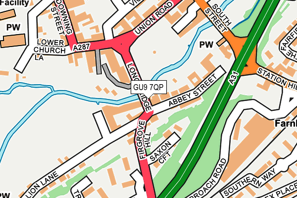
GU9 7QP lies on Bridge Square in Farnham. GU9 7QP is located in the Farnham Castle electoral ward, within the local authority district of Waverley and the English Parliamentary constituency of South West Surrey. The Sub Integrated Care Board (ICB) Location is NHS Frimley ICB - D4U1Y and the police force is Surrey. This postcode has been in use since January 1980.


GetTheData
Source: OS OpenMap – Local (Ordnance Survey)
Source: OS VectorMap District (Ordnance Survey)
Licence: Open Government Licence (requires attribution)
| Easting | 484137 |
| Northing | 146566 |
| Latitude | 51.212108 |
| Longitude | -0.796828 |
GetTheData
Source: Open Postcode Geo
Licence: Open Government Licence
| Street | Bridge Square |
| Town/City | Farnham |
| Country | England |
| Postcode District | GU9 |
➜ See where GU9 is on a map ➜ Where is Farnham? | |
GetTheData
Source: Land Registry Price Paid Data
Licence: Open Government Licence
Elevation or altitude of GU9 7QP as distance above sea level:
| Metres | Feet | |
|---|---|---|
| Elevation | 70m | 230ft |
Elevation is measured from the approximate centre of the postcode, to the nearest point on an OS contour line from OS Terrain 50, which has contour spacing of ten vertical metres.
➜ How high above sea level am I? Find the elevation of your current position using your device's GPS.
GetTheData
Source: Open Postcode Elevation
Licence: Open Government Licence
| Ward | Farnham Castle |
| Constituency | South West Surrey |
GetTheData
Source: ONS Postcode Database
Licence: Open Government Licence
| Union Road | Farnham | 142m |
| Farnham Station Forecourt (Station Road) | Farnham | 271m |
| Farnham Station Forecourt (Station Hill) | Farnham | 282m |
| South Street | Farnham | 283m |
| Alfred Road (Firgrove Hill) | Farnham | 334m |
| Farnham Station | 0.3km |
| Aldershot Station | 4.6km |
| Bentley (Hants) Station | 6.1km |
GetTheData
Source: NaPTAN
Licence: Open Government Licence
| Percentage of properties with Next Generation Access | 100.0% |
| Percentage of properties with Superfast Broadband | 100.0% |
| Percentage of properties with Ultrafast Broadband | 0.0% |
| Percentage of properties with Full Fibre Broadband | 0.0% |
Superfast Broadband is between 30Mbps and 300Mbps
Ultrafast Broadband is > 300Mbps
| Percentage of properties unable to receive 2Mbps | 0.0% |
| Percentage of properties unable to receive 5Mbps | 0.0% |
| Percentage of properties unable to receive 10Mbps | 0.0% |
| Percentage of properties unable to receive 30Mbps | 0.0% |
GetTheData
Source: Ofcom
Licence: Ofcom Terms of Use (requires attribution)
GetTheData
Source: ONS Postcode Database
Licence: Open Government Licence


➜ Get more ratings from the Food Standards Agency
GetTheData
Source: Food Standards Agency
Licence: FSA terms & conditions
| Last Collection | |||
|---|---|---|---|
| Location | Mon-Fri | Sat | Distance |
| Downing Street | 17:30 | 12:00 | 155m |
| Trafalgar Court | 17:30 | 12:00 | 194m |
| South Street | 17:30 | 12:00 | 255m |
GetTheData
Source: Dracos
Licence: Creative Commons Attribution-ShareAlike
| Risk of GU9 7QP flooding from rivers and sea | Medium |
| ➜ GU9 7QP flood map | |
GetTheData
Source: Open Flood Risk by Postcode
Licence: Open Government Licence
The below table lists the International Territorial Level (ITL) codes (formerly Nomenclature of Territorial Units for Statistics (NUTS) codes) and Local Administrative Units (LAU) codes for GU9 7QP:
| ITL 1 Code | Name |
|---|---|
| TLJ | South East (England) |
| ITL 2 Code | Name |
| TLJ2 | Surrey, East and West Sussex |
| ITL 3 Code | Name |
| TLJ25 | West Surrey |
| LAU 1 Code | Name |
| E07000216 | Waverley |
GetTheData
Source: ONS Postcode Directory
Licence: Open Government Licence
The below table lists the Census Output Area (OA), Lower Layer Super Output Area (LSOA), and Middle Layer Super Output Area (MSOA) for GU9 7QP:
| Code | Name | |
|---|---|---|
| OA | E00157480 | |
| LSOA | E01030885 | Waverley 003B |
| MSOA | E02006441 | Waverley 003 |
GetTheData
Source: ONS Postcode Directory
Licence: Open Government Licence
| GU9 7RL | Abbey Street | 39m |
| GU9 7QR | Bridge Square | 57m |
| GU9 7RJ | Abbey Street | 68m |
| GU9 7RT | Abbey Street | 99m |
| GU9 7QB | Saxon Croft | 123m |
| GU9 7NX | Downing Street | 133m |
| GU9 7RQ | Abbey Street | 134m |
| GU9 7QD | Firgrove Court | 151m |
| GU9 7RH | South Street | 159m |
| GU9 7PN | Downing Street | 163m |
GetTheData
Source: Open Postcode Geo; Land Registry Price Paid Data
Licence: Open Government Licence