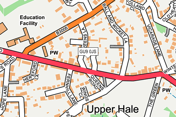
GU9 0JS lies on Wellesley Garden in Farnham. GU9 0JS is located in the Farnham Heath End electoral ward, within the local authority district of Waverley and the English Parliamentary constituency of South West Surrey. The Sub Integrated Care Board (ICB) Location is NHS Frimley ICB - D4U1Y and the police force is Surrey. This postcode has been in use since February 1984.


GetTheData
Source: OS OpenMap – Local (Ordnance Survey)
Source: OS VectorMap District (Ordnance Survey)
Licence: Open Government Licence (requires attribution)
| Easting | 484004 |
| Northing | 149056 |
| Latitude | 51.234515 |
| Longitude | -0.798166 |
GetTheData
Source: Open Postcode Geo
Licence: Open Government Licence
| Street | Wellesley Garden |
| Town/City | Farnham |
| Country | England |
| Postcode District | GU9 |
➜ See where GU9 is on a map ➜ Where is Upper Hale? | |
GetTheData
Source: Land Registry Price Paid Data
Licence: Open Government Licence
Elevation or altitude of GU9 0JS as distance above sea level:
| Metres | Feet | |
|---|---|---|
| Elevation | 150m | 492ft |
Elevation is measured from the approximate centre of the postcode, to the nearest point on an OS contour line from OS Terrain 50, which has contour spacing of ten vertical metres.
➜ How high above sea level am I? Find the elevation of your current position using your device's GPS.
GetTheData
Source: Open Postcode Elevation
Licence: Open Government Licence
| Ward | Farnham Heath End |
| Constituency | South West Surrey |
GetTheData
Source: ONS Postcode Database
Licence: Open Government Licence
2018 20 SEP £737,500 |
1998 30 OCT £227,000 |
GetTheData
Source: HM Land Registry Price Paid Data
Licence: Contains HM Land Registry data © Crown copyright and database right 2025. This data is licensed under the Open Government Licence v3.0.
| War Memorial (Upper Hale Road) | Upper Hale | 95m |
| Hereford Lane (Upper Hale Road) | Upper Hale | 176m |
| Tesco Express (Upper Hale Road) | Farnham | 184m |
| Tesco Express (Alma Lane) | Farnham | 206m |
| Tesco Express (Alma Lane) | Farnham | 207m |
| Farnham Station | 2.5km |
| Aldershot Station | 3km |
| North Camp Station | 6.6km |
GetTheData
Source: NaPTAN
Licence: Open Government Licence
| Percentage of properties with Next Generation Access | 100.0% |
| Percentage of properties with Superfast Broadband | 100.0% |
| Percentage of properties with Ultrafast Broadband | 0.0% |
| Percentage of properties with Full Fibre Broadband | 0.0% |
Superfast Broadband is between 30Mbps and 300Mbps
Ultrafast Broadband is > 300Mbps
| Percentage of properties unable to receive 2Mbps | 0.0% |
| Percentage of properties unable to receive 5Mbps | 0.0% |
| Percentage of properties unable to receive 10Mbps | 0.0% |
| Percentage of properties unable to receive 30Mbps | 0.0% |
GetTheData
Source: Ofcom
Licence: Ofcom Terms of Use (requires attribution)
GetTheData
Source: ONS Postcode Database
Licence: Open Government Licence


➜ Get more ratings from the Food Standards Agency
GetTheData
Source: Food Standards Agency
Licence: FSA terms & conditions
| Last Collection | |||
|---|---|---|---|
| Location | Mon-Fri | Sat | Distance |
| Hale School | 17:00 | 11:30 | 252m |
| Wings Road | 17:00 | 11:30 | 289m |
| Upper Hale | 17:00 | 12:00 | 557m |
GetTheData
Source: Dracos
Licence: Creative Commons Attribution-ShareAlike
The below table lists the International Territorial Level (ITL) codes (formerly Nomenclature of Territorial Units for Statistics (NUTS) codes) and Local Administrative Units (LAU) codes for GU9 0JS:
| ITL 1 Code | Name |
|---|---|
| TLJ | South East (England) |
| ITL 2 Code | Name |
| TLJ2 | Surrey, East and West Sussex |
| ITL 3 Code | Name |
| TLJ25 | West Surrey |
| LAU 1 Code | Name |
| E07000216 | Waverley |
GetTheData
Source: ONS Postcode Directory
Licence: Open Government Licence
The below table lists the Census Output Area (OA), Lower Layer Super Output Area (LSOA), and Middle Layer Super Output Area (MSOA) for GU9 0JS:
| Code | Name | |
|---|---|---|
| OA | E00157541 | |
| LSOA | E01030899 | Waverley 002C |
| MSOA | E02006440 | Waverley 002 |
GetTheData
Source: ONS Postcode Directory
Licence: Open Government Licence
| GU9 0LU | Queens Lane | 52m |
| GU9 0JW | Upper Hale Road | 59m |
| GU9 0JN | Upper Hale Road | 60m |
| GU9 0LL | Queens Lane | 68m |
| GU9 0HP | Queens Road | 90m |
| GU9 0HE | Wings Close | 100m |
| GU9 0LT | Alma Lane | 107m |
| GU9 0JH | Upper Hale Road | 116m |
| GU9 0PD | Ball & Wicket Lane | 121m |
| GU9 0JG | Upper Hale Road | 143m |
GetTheData
Source: Open Postcode Geo; Land Registry Price Paid Data
Licence: Open Government Licence