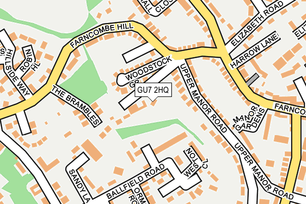
GU7 2HQ is located in the Godalming Binscombe & Charterhouse electoral ward, within the local authority district of Waverley and the English Parliamentary constituency of South West Surrey. The Sub Integrated Care Board (ICB) Location is NHS Surrey Heartlands ICB - 92A and the police force is Surrey. This postcode has been in use since December 1995.


GetTheData
Source: OS OpenMap – Local (Ordnance Survey)
Source: OS VectorMap District (Ordnance Survey)
Licence: Open Government Licence (requires attribution)
| Easting | 497085 |
| Northing | 145064 |
| Latitude | 51.196557 |
| Longitude | -0.611938 |
GetTheData
Source: Open Postcode Geo
Licence: Open Government Licence
| Country | England |
| Postcode District | GU7 |
| ➜ GU7 open data dashboard ➜ See where GU7 is on a map ➜ Where is Farncombe? | |
GetTheData
Source: Land Registry Price Paid Data
Licence: Open Government Licence
Elevation or altitude of GU7 2HQ as distance above sea level:
| Metres | Feet | |
|---|---|---|
| Elevation | 70m | 230ft |
Elevation is measured from the approximate centre of the postcode, to the nearest point on an OS contour line from OS Terrain 50, which has contour spacing of ten vertical metres.
➜ How high above sea level am I? Find the elevation of your current position using your device's GPS.
GetTheData
Source: Open Postcode Elevation
Licence: Open Government Licence
| Ward | Godalming Binscombe & Charterhouse |
| Constituency | South West Surrey |
GetTheData
Source: ONS Postcode Database
Licence: Open Government Licence
| January 2024 | Criminal damage and arson | On or near Twycross Road | 436m |
| December 2023 | Violence and sexual offences | On or near Parking Area | 476m |
| November 2023 | Burglary | On or near Hall Close | 194m |
| ➜ Get more crime data in our Crime section | |||
GetTheData
Source: data.police.uk
Licence: Open Government Licence
| Farncombe Hill (Binscombe Lane) | Farncombe | 169m |
| Farncombe Hill (Farncombe Street) | Farncombe | 170m |
| Elizabeth Road | Farncombe | 206m |
| Elizabeth Road | Farncombe | 226m |
| Post Office (Farncombe Street) | Farncombe | 249m |
| Farncombe Station | 0.5km |
| Godalming Station | 1.2km |
| Shalford (Surrey) Station | 3.7km |
GetTheData
Source: NaPTAN
Licence: Open Government Licence
| Percentage of properties with Next Generation Access | 100.0% |
| Percentage of properties with Superfast Broadband | 100.0% |
| Percentage of properties with Ultrafast Broadband | 0.0% |
| Percentage of properties with Full Fibre Broadband | 0.0% |
Superfast Broadband is between 30Mbps and 300Mbps
Ultrafast Broadband is > 300Mbps
| Percentage of properties unable to receive 2Mbps | 0.0% |
| Percentage of properties unable to receive 5Mbps | 0.0% |
| Percentage of properties unable to receive 10Mbps | 0.0% |
| Percentage of properties unable to receive 30Mbps | 0.0% |
GetTheData
Source: Ofcom
Licence: Ofcom Terms of Use (requires attribution)
GetTheData
Source: ONS Postcode Database
Licence: Open Government Licence


➜ Get more ratings from the Food Standards Agency
GetTheData
Source: Food Standards Agency
Licence: FSA terms & conditions
| Last Collection | |||
|---|---|---|---|
| Location | Mon-Fri | Sat | Distance |
| Farncombe Hill | 16:45 | 12:00 | 96m |
| Frith Hill | 16:45 | 12:00 | 372m |
| Farncombe Post Office | 17:00 | 12:00 | 383m |
GetTheData
Source: Dracos
Licence: Creative Commons Attribution-ShareAlike
| Facility | Distance |
|---|---|
| Cannon Bowering Recreation Ground (Closed) Warren Road, Godalming Grass Pitches | 633m |
| Charterhouse School Hurtmore Road, Godalming Swimming Pool, Health and Fitness Gym, Sports Hall, Athletics, Grass Pitches, Studio, Artificial Grass Pitch, Golf, Outdoor Tennis Courts | 658m |
| Godalming Town Football Club Wey Court, Godalming Grass Pitches | 1km |
GetTheData
Source: Active Places
Licence: Open Government Licence
| School | Phase of Education | Distance |
|---|---|---|
| Farncombe Church of England Infant School Grays Road, Farncombe, Godalming, GU7 3LT | Primary | 437m |
| Charterhouse Godalming, GU7 2DX | Not applicable | 671m |
| Godalming Junior School Hallam Road, Godalming, GU7 3HW | Primary | 743m |
GetTheData
Source: Edubase
Licence: Open Government Licence
The below table lists the International Territorial Level (ITL) codes (formerly Nomenclature of Territorial Units for Statistics (NUTS) codes) and Local Administrative Units (LAU) codes for GU7 2HQ:
| ITL 1 Code | Name |
|---|---|
| TLJ | South East (England) |
| ITL 2 Code | Name |
| TLJ2 | Surrey, East and West Sussex |
| ITL 3 Code | Name |
| TLJ25 | West Surrey |
| LAU 1 Code | Name |
| E07000216 | Waverley |
GetTheData
Source: ONS Postcode Directory
Licence: Open Government Licence
The below table lists the Census Output Area (OA), Lower Layer Super Output Area (LSOA), and Middle Layer Super Output Area (MSOA) for GU7 2HQ:
| Code | Name | |
|---|---|---|
| OA | E00157628 | |
| LSOA | E01030919 | Waverley 007D |
| MSOA | E02006445 | Waverley 007 |
GetTheData
Source: ONS Postcode Directory
Licence: Open Government Licence
| GU7 2BF | Fernden Rise | 58m |
| GU7 2AX | Woodstock Grove | 78m |
| GU7 2HD | Ballfield Road | 83m |
| GU7 2HF | Little Tumners Court | 102m |
| GU7 2HZ | Upper Manor Road | 115m |
| GU7 2HB | Ballfield Road | 126m |
| GU7 2AU | Farncombe Hill | 135m |
| GU7 2BP | Farncombe Hill | 136m |
| GU7 2EY | Weston Close | 138m |
| GU7 2AY | Farncombe Hill | 142m |
GetTheData
Source: Open Postcode Geo; Land Registry Price Paid Data
Licence: Open Government Licence