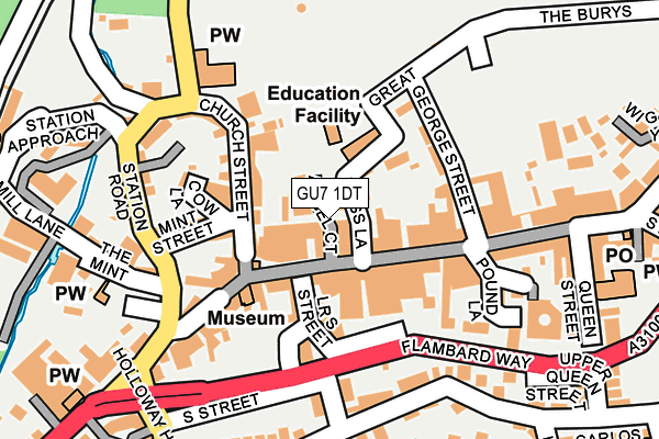
GU7 1DT is located in the Godalming Central & Ockford electoral ward, within the local authority district of Waverley and the English Parliamentary constituency of South West Surrey. The Sub Integrated Care Board (ICB) Location is NHS Surrey Heartlands ICB - 92A and the police force is Surrey. This postcode has been in use since June 1981.


GetTheData
Source: OS OpenMap – Local (Ordnance Survey)
Source: OS VectorMap District (Ordnance Survey)
Licence: Open Government Licence (requires attribution)
| Easting | 496929 |
| Northing | 143864 |
| Latitude | 51.185792 |
| Longitude | -0.614473 |
GetTheData
Source: Open Postcode Geo
Licence: Open Government Licence
| Country | England |
| Postcode District | GU7 |
| ➜ GU7 open data dashboard ➜ See where GU7 is on a map ➜ Where is Godalming? | |
GetTheData
Source: Land Registry Price Paid Data
Licence: Open Government Licence
Elevation or altitude of GU7 1DT as distance above sea level:
| Metres | Feet | |
|---|---|---|
| Elevation | 50m | 164ft |
Elevation is measured from the approximate centre of the postcode, to the nearest point on an OS contour line from OS Terrain 50, which has contour spacing of ten vertical metres.
➜ How high above sea level am I? Find the elevation of your current position using your device's GPS.
GetTheData
Source: Open Postcode Elevation
Licence: Open Government Licence
| Ward | Godalming Central & Ockford |
| Constituency | South West Surrey |
GetTheData
Source: ONS Postcode Database
Licence: Open Government Licence
| January 2024 | Criminal damage and arson | On or near Parking Area | 141m |
| January 2024 | Vehicle crime | On or near Parking Area | 141m |
| January 2024 | Anti-social behaviour | On or near Parking Area | 312m |
| ➜ Get more crime data in our Crime section | |||
GetTheData
Source: data.police.uk
Licence: Open Government Licence
| Pepperpot (High Street) | Godalming | 101m |
| Godalming Railway Station (Station Road) | Godalming | 182m |
| Flambard Way | Godalming | 189m |
| Godalming Railway Station (Station Road) | Godalming | 191m |
| Borough Road | Godalming | 233m |
| Godalming Station | 0.3km |
| Farncombe Station | 1.4km |
| Milford (Surrey) Station | 3km |
GetTheData
Source: NaPTAN
Licence: Open Government Licence
GetTheData
Source: ONS Postcode Database
Licence: Open Government Licence


➜ Get more ratings from the Food Standards Agency
GetTheData
Source: Food Standards Agency
Licence: FSA terms & conditions
| Last Collection | |||
|---|---|---|---|
| Location | Mon-Fri | Sat | Distance |
| High Street | 18:45 | 12:00 | 40m |
| High Street | 18:45 | 12:00 | 133m |
| Croft Road | 17:15 | 12:00 | 208m |
GetTheData
Source: Dracos
Licence: Creative Commons Attribution-ShareAlike
| Facility | Distance |
|---|---|
| Zest Goldalming Ltd (Closed) Great George Street, Godalming Health and Fitness Gym, Studio | 118m |
| Snap Fitness (Godalming) High Street, Godalming Health and Fitness Gym, Studio | 165m |
| The Burys Field The Burys, Godalming Grass Pitches | 258m |
GetTheData
Source: Active Places
Licence: Open Government Licence
| School | Phase of Education | Distance |
|---|---|---|
| Moss Lane School Moss Lane, Godalming, GU7 1EF | Primary | 70m |
| The Wharf Nursery School The Wharf, Woolsack Way, Woolsack Way, Godalming, GU7 1JG | Nursery | 525m |
| St Hilary's School Holloway Hill, Godalming, GU7 1RZ | Not applicable | 548m |
GetTheData
Source: Edubase
Licence: Open Government Licence
The below table lists the International Territorial Level (ITL) codes (formerly Nomenclature of Territorial Units for Statistics (NUTS) codes) and Local Administrative Units (LAU) codes for GU7 1DT:
| ITL 1 Code | Name |
|---|---|
| TLJ | South East (England) |
| ITL 2 Code | Name |
| TLJ2 | Surrey, East and West Sussex |
| ITL 3 Code | Name |
| TLJ25 | West Surrey |
| LAU 1 Code | Name |
| E07000216 | Waverley |
GetTheData
Source: ONS Postcode Directory
Licence: Open Government Licence
The below table lists the Census Output Area (OA), Lower Layer Super Output Area (LSOA), and Middle Layer Super Output Area (MSOA) for GU7 1DT:
| Code | Name | |
|---|---|---|
| OA | E00157618 | |
| LSOA | E01030916 | Waverley 007A |
| MSOA | E02006445 | Waverley 007 |
GetTheData
Source: ONS Postcode Directory
Licence: Open Government Licence
| GU7 1EA | Angel Court | 34m |
| GU7 1DW | High Street | 45m |
| GU7 1AW | High Street | 51m |
| GU7 1AR | High Street | 58m |
| GU7 1DU | High Street | 76m |
| GU7 1EH | Church Street | 77m |
| GU7 1EG | Moss Lane | 83m |
| GU7 1EQ | Church Street | 92m |
| GU7 1BZ | Lower South Street | 96m |
| GU7 1EW | Church Street | 98m |
GetTheData
Source: Open Postcode Geo; Land Registry Price Paid Data
Licence: Open Government Licence