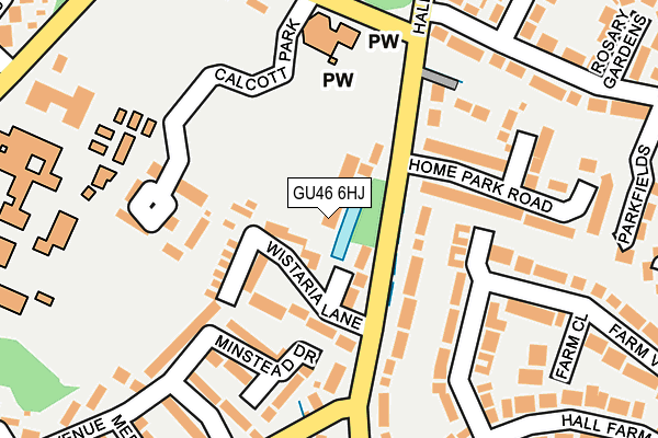
GU46 6HJ is located in the Yateley West electoral ward, within the local authority district of Hart and the English Parliamentary constituency of North East Hampshire. The Sub Integrated Care Board (ICB) Location is NHS Frimley ICB - D4U1Y and the police force is Hampshire. This postcode has been in use since June 1996.


GetTheData
Source: OS OpenMap – Local (Ordnance Survey)
Source: OS VectorMap District (Ordnance Survey)
Licence: Open Government Licence (requires attribution)
| Easting | 481402 |
| Northing | 160495 |
| Latitude | 51.337727 |
| Longitude | -0.832824 |
GetTheData
Source: Open Postcode Geo
Licence: Open Government Licence
| Country | England |
| Postcode District | GU46 |
➜ See where GU46 is on a map ➜ Where is Yateley? | |
GetTheData
Source: Land Registry Price Paid Data
Licence: Open Government Licence
Elevation or altitude of GU46 6HJ as distance above sea level:
| Metres | Feet | |
|---|---|---|
| Elevation | 70m | 230ft |
Elevation is measured from the approximate centre of the postcode, to the nearest point on an OS contour line from OS Terrain 50, which has contour spacing of ten vertical metres.
➜ How high above sea level am I? Find the elevation of your current position using your device's GPS.
GetTheData
Source: Open Postcode Elevation
Licence: Open Government Licence
| Ward | Yateley West |
| Constituency | North East Hampshire |
GetTheData
Source: ONS Postcode Database
Licence: Open Government Licence
| Home Park Road (Hall Lane) | Yateley | 79m |
| Home Park Road (Hall Lane) | Yateley | 117m |
| St Swithuns Church (Firgrove Road) | Yateley | 190m |
| St Swithuns Church (Firgrove Road) | Yateley | 199m |
| Coppice Gardens (Vigo Lane) | Yateley | 210m |
| Sandhurst Station | 2.2km |
| Crowthorne Station | 3.4km |
| Blackwater Station | 4km |
GetTheData
Source: NaPTAN
Licence: Open Government Licence
GetTheData
Source: ONS Postcode Database
Licence: Open Government Licence


➜ Get more ratings from the Food Standards Agency
GetTheData
Source: Food Standards Agency
Licence: FSA terms & conditions
| Last Collection | |||
|---|---|---|---|
| Location | Mon-Fri | Sat | Distance |
| Lymington Avenue | 16:30 | 11:45 | 236m |
| Cranford Park | 16:45 | 12:15 | 394m |
| Handford Lane | 16:30 | 11:45 | 422m |
GetTheData
Source: Dracos
Licence: Creative Commons Attribution-ShareAlike
| Risk of GU46 6HJ flooding from rivers and sea | Medium |
| ➜ GU46 6HJ flood map | |
GetTheData
Source: Open Flood Risk by Postcode
Licence: Open Government Licence
The below table lists the International Territorial Level (ITL) codes (formerly Nomenclature of Territorial Units for Statistics (NUTS) codes) and Local Administrative Units (LAU) codes for GU46 6HJ:
| ITL 1 Code | Name |
|---|---|
| TLJ | South East (England) |
| ITL 2 Code | Name |
| TLJ3 | Hampshire and Isle of Wight |
| ITL 3 Code | Name |
| TLJ37 | North Hampshire |
| LAU 1 Code | Name |
| E07000089 | Hart |
GetTheData
Source: ONS Postcode Directory
Licence: Open Government Licence
The below table lists the Census Output Area (OA), Lower Layer Super Output Area (LSOA), and Middle Layer Super Output Area (MSOA) for GU46 6HJ:
| Code | Name | |
|---|---|---|
| OA | E00116350 | |
| LSOA | E01022898 | Hart 002E |
| MSOA | E02004752 | Hart 002 |
GetTheData
Source: ONS Postcode Directory
Licence: Open Government Licence
| GU46 6HY | Wistaria Lane | 78m |
| GU46 6HP | Hall Lane | 105m |
| GU46 6EH | Minstead Drive | 132m |
| GU46 6JJ | Calcott Park | 144m |
| GU46 6HN | Home Park Road | 155m |
| GU46 6EE | Vigo Lane | 165m |
| GU46 6HU | Farm View | 170m |
| GU46 6EG | Lymington Avenue | 191m |
| GU46 6HW | Woodbourne Close | 201m |
| GU46 6HX | Farm Close | 228m |
GetTheData
Source: Open Postcode Geo; Land Registry Price Paid Data
Licence: Open Government Licence