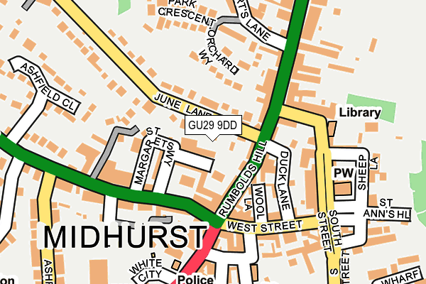
GU29 9DD is located in the Midhurst electoral ward, within the local authority district of Chichester and the English Parliamentary constituency of Chichester. The Sub Integrated Care Board (ICB) Location is NHS Sussex ICB - 70F and the police force is Sussex. This postcode has been in use since January 1980.


GetTheData
Source: OS OpenMap – Local (Ordnance Survey)
Source: OS VectorMap District (Ordnance Survey)
Licence: Open Government Licence (requires attribution)
| Easting | 488532 |
| Northing | 121547 |
| Latitude | 50.986528 |
| Longitude | -0.740069 |
GetTheData
Source: Open Postcode Geo
Licence: Open Government Licence
| Country | England |
| Postcode District | GU29 |
| ➜ GU29 open data dashboard ➜ See where GU29 is on a map ➜ Where is Midhurst? | |
GetTheData
Source: Land Registry Price Paid Data
Licence: Open Government Licence
Elevation or altitude of GU29 9DD as distance above sea level:
| Metres | Feet | |
|---|---|---|
| Elevation | 30m | 98ft |
Elevation is measured from the approximate centre of the postcode, to the nearest point on an OS contour line from OS Terrain 50, which has contour spacing of ten vertical metres.
➜ How high above sea level am I? Find the elevation of your current position using your device's GPS.
GetTheData
Source: Open Postcode Elevation
Licence: Open Government Licence
| Ward | Midhurst |
| Constituency | Chichester |
GetTheData
Source: ONS Postcode Database
Licence: Open Government Licence
| January 2024 | Violence and sexual offences | On or near Church Hill | 165m |
| June 2022 | Violence and sexual offences | On or near Duck Lane | 112m |
| June 2022 | Shoplifting | On or near Police Station | 183m |
| ➜ Get more crime data in our Crime section | |||
GetTheData
Source: data.police.uk
Licence: Open Government Licence
| Convent (A272 Petersfield Road) | Midhurst | 89m |
| Convent (A272 Petersfield Road) | Midhurst | 128m |
| Lamberts Lane (North Street) | Midhurst | 148m |
| Police Station (Bepton Road) | Midhurst | 169m |
| Police Station (Bepton Road) | Midhurst | 175m |
GetTheData
Source: NaPTAN
Licence: Open Government Licence
GetTheData
Source: ONS Postcode Database
Licence: Open Government Licence


➜ Get more ratings from the Food Standards Agency
GetTheData
Source: Food Standards Agency
Licence: FSA terms & conditions
| Last Collection | |||
|---|---|---|---|
| Location | Mon-Fri | Sat | Distance |
| Orchard Way | 17:00 | 11:15 | 180m |
| Midhurst Delivery Office | 18:00 | 12:30 | 182m |
| North Street Post Office | 17:30 | 12:00 | 244m |
GetTheData
Source: Dracos
Licence: Creative Commons Attribution-ShareAlike
| Facility | Distance |
|---|---|
| Spread Eagle Spa South Street, Midhurst Health and Fitness Gym, Swimming Pool | 200m |
| The Grange Community & Leisure Centre Bepton Road, Midhurst Sports Hall, Health and Fitness Gym, Squash Courts, Studio | 260m |
| Grange Centre (Midhurst) (Closed) Bepton Road, Midhurst Sports Hall, Health and Fitness Gym, Studio, Squash Courts | 280m |
GetTheData
Source: Active Places
Licence: Open Government Licence
| School | Phase of Education | Distance |
|---|---|---|
| Midhurst Rother College North Street, Midhurst, GU29 9DT | Secondary | 342m |
| Midhurst CofE Primary School Ashfield Road, Midhurst, GU29 9JX | Primary | 444m |
| Conifers School Egmont Road, Midhurst, GU29 9BG | Not applicable | 1.1km |
GetTheData
Source: Edubase
Licence: Open Government Licence
The below table lists the International Territorial Level (ITL) codes (formerly Nomenclature of Territorial Units for Statistics (NUTS) codes) and Local Administrative Units (LAU) codes for GU29 9DD:
| ITL 1 Code | Name |
|---|---|
| TLJ | South East (England) |
| ITL 2 Code | Name |
| TLJ2 | Surrey, East and West Sussex |
| ITL 3 Code | Name |
| TLJ27 | West Sussex (South West) |
| LAU 1 Code | Name |
| E07000225 | Chichester |
GetTheData
Source: ONS Postcode Directory
Licence: Open Government Licence
The below table lists the Census Output Area (OA), Lower Layer Super Output Area (LSOA), and Middle Layer Super Output Area (MSOA) for GU29 9DD:
| Code | Name | |
|---|---|---|
| OA | E00160715 | |
| LSOA | E01032717 | Chichester 004F |
| MSOA | E02006564 | Chichester 004 |
GetTheData
Source: ONS Postcode Directory
Licence: Open Government Licence
| GU29 9DA | Rumbolds Hill | 53m |
| GU29 9FW | St Margarets Way | 68m |
| GU29 9DG | Rumbolds Hill | 75m |
| GU29 9FQ | St Margarets Way | 77m |
| GU29 9BY | Rumbolds Hill | 81m |
| GU29 9ND | Egmont Mews | 84m |
| GU29 9FD | Egremont Mews | 85m |
| GU29 9EL | June Lane | 92m |
| GU29 9BX | Wool Lane | 101m |
| GU29 9EE | Orchard Way | 103m |
GetTheData
Source: Open Postcode Geo; Land Registry Price Paid Data
Licence: Open Government Licence