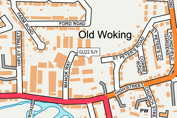
GU22 9JY is located in the Hoe Valley electoral ward, within the local authority district of Woking and the English Parliamentary constituency of Woking. The Sub Integrated Care Board (ICB) Location is NHS Surrey Heartlands ICB - 92A and the police force is Surrey. This postcode has been in use since June 1999.


GetTheData
Source: OS OpenMap – Local (Ordnance Survey)
Source: OS VectorMap District (Ordnance Survey)
Licence: Open Government Licence (requires attribution)
| Easting | 501831 |
| Northing | 157034 |
| Latitude | 51.303329 |
| Longitude | -0.540636 |
GetTheData
Source: Open Postcode Geo
Licence: Open Government Licence
| Country | England |
| Postcode District | GU22 |
| ➜ GU22 open data dashboard ➜ See where GU22 is on a map ➜ Where is Woking? | |
GetTheData
Source: Land Registry Price Paid Data
Licence: Open Government Licence
Elevation or altitude of GU22 9JY as distance above sea level:
| Metres | Feet | |
|---|---|---|
| Elevation | 30m | 98ft |
Elevation is measured from the approximate centre of the postcode, to the nearest point on an OS contour line from OS Terrain 50, which has contour spacing of ten vertical metres.
➜ How high above sea level am I? Find the elevation of your current position using your device's GPS.
GetTheData
Source: Open Postcode Elevation
Licence: Open Government Licence
| Ward | Hoe Valley |
| Constituency | Woking |
GetTheData
Source: ONS Postcode Database
Licence: Open Government Licence
| June 2022 | Violence and sexual offences | On or near Manor Way | 96m |
| June 2022 | Criminal damage and arson | On or near Manor Way | 96m |
| June 2022 | Violence and sexual offences | On or near High Street | 189m |
| ➜ Get more crime data in our Crime section | |||
GetTheData
Source: data.police.uk
Licence: Open Government Licence
| Manor Way (High Street) | Old Woking | 149m |
| Manor Way (High Street) | Old Woking | 174m |
| Rydens Way Shops (Rydens Way) | Old Woking | 221m |
| Carters Lane (Old Woking Road) | Old Woking | 303m |
| Crown And Anchor (High Street) | Old Woking | 311m |
| Woking Station | 2km |
| Worplesdon Station | 3.3km |
| West Byfleet Station | 4.7km |
GetTheData
Source: NaPTAN
Licence: Open Government Licence
GetTheData
Source: ONS Postcode Database
Licence: Open Government Licence


➜ Get more ratings from the Food Standards Agency
GetTheData
Source: Food Standards Agency
Licence: FSA terms & conditions
| Last Collection | |||
|---|---|---|---|
| Location | Mon-Fri | Sat | Distance |
| Old Woking Post Office | 17:30 | 12:00 | 164m |
| St Peters Road | 17:00 | 11:45 | 182m |
| Kingfield Post Office | 17:45 | 12:00 | 747m |
GetTheData
Source: Dracos
Licence: Creative Commons Attribution-ShareAlike
| Facility | Distance |
|---|---|
| St. Peters Palace Way, Woking Grass Pitches | 181m |
| Hoe Bridge School Old Woking Road, Woking Artificial Grass Pitch, Swimming Pool, Grass Pitches | 592m |
| Woking College Rydens Way, Woking Sports Hall, Health and Fitness Gym, Grass Pitches, Outdoor Tennis Courts, Artificial Grass Pitch, Studio, Athletics | 661m |
GetTheData
Source: Active Places
Licence: Open Government Licence
| School | Phase of Education | Distance |
|---|---|---|
| Hoe Bridge School Hoe Place, Old Woking Road, Woking, Surrey, GU22 8JE | Not applicable | 591m |
| Woking College Rydens Way, Woking, GU22 9DL | 16 plus | 662m |
| Kingfield Primary School Kingfield Road, Woking, GU22 9EQ | Primary | 708m |
GetTheData
Source: Edubase
Licence: Open Government Licence
The below table lists the International Territorial Level (ITL) codes (formerly Nomenclature of Territorial Units for Statistics (NUTS) codes) and Local Administrative Units (LAU) codes for GU22 9JY:
| ITL 1 Code | Name |
|---|---|
| TLJ | South East (England) |
| ITL 2 Code | Name |
| TLJ2 | Surrey, East and West Sussex |
| ITL 3 Code | Name |
| TLJ25 | West Surrey |
| LAU 1 Code | Name |
| E07000217 | Woking |
GetTheData
Source: ONS Postcode Directory
Licence: Open Government Licence
The below table lists the Census Output Area (OA), Lower Layer Super Output Area (LSOA), and Middle Layer Super Output Area (MSOA) for GU22 9JY:
| Code | Name | |
|---|---|---|
| OA | E00157995 | |
| LSOA | E01030994 | Woking 011D |
| MSOA | E02006466 | Woking 011 |
GetTheData
Source: ONS Postcode Directory
Licence: Open Government Licence
| GU22 9JG | St Peters Road | 111m |
| GU22 9JS | High Street | 124m |
| GU22 9JW | High Street | 139m |
| GU22 9HP | Ford Road | 140m |
| GU22 9JN | High Street | 156m |
| GU22 9JQ | St Peters Road | 157m |
| GU22 9JD | Townsend Lane | 158m |
| GU22 9HJ | Ford Road | 177m |
| GU22 9JA | The Cloisters | 184m |
| GU22 9JP | Corrie Road | 194m |
GetTheData
Source: Open Postcode Geo; Land Registry Price Paid Data
Licence: Open Government Licence