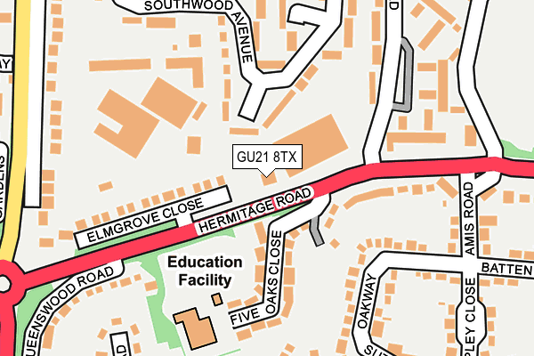
GU21 8TX is located in the St John's electoral ward, within the local authority district of Woking and the English Parliamentary constituency of Woking. The Sub Integrated Care Board (ICB) Location is NHS Surrey Heartlands ICB - 92A and the police force is Surrey. This postcode has been in use since June 2002.


GetTheData
Source: OS OpenMap – Local (Ordnance Survey)
Source: OS VectorMap District (Ordnance Survey)
Licence: Open Government Licence (requires attribution)
| Easting | 497004 |
| Northing | 157968 |
| Latitude | 51.312567 |
| Longitude | -0.609602 |
GetTheData
Source: Open Postcode Geo
Licence: Open Government Licence
| Country | England |
| Postcode District | GU21 |
| ➜ GU21 open data dashboard ➜ See where GU21 is on a map ➜ Where is Woking? | |
GetTheData
Source: Land Registry Price Paid Data
Licence: Open Government Licence
Elevation or altitude of GU21 8TX as distance above sea level:
| Metres | Feet | |
|---|---|---|
| Elevation | 50m | 164ft |
Elevation is measured from the approximate centre of the postcode, to the nearest point on an OS contour line from OS Terrain 50, which has contour spacing of ten vertical metres.
➜ How high above sea level am I? Find the elevation of your current position using your device's GPS.
GetTheData
Source: Open Postcode Elevation
Licence: Open Government Licence
| Ward | St John's |
| Constituency | Woking |
GetTheData
Source: ONS Postcode Database
Licence: Open Government Licence
| October 2023 | Anti-social behaviour | On or near Hermitage Road | 231m |
| October 2023 | Anti-social behaviour | On or near Hermitage Road | 231m |
| September 2023 | Criminal damage and arson | On or near Hermitage Road | 231m |
| ➜ Get more crime data in our Crime section | |||
GetTheData
Source: data.police.uk
Licence: Open Government Licence
| The Surrey Hermitage (Hermitage Road) | Knaphill | 55m |
| The Surrey Hermitage (Hermitage Road) | Knaphill | 59m |
| Queenswood Road (Hermitage Road) | Knaphill | 224m |
| Raglan Road Turn (Raglan Road) | St Johns | 244m |
| Raglan Road Turn (Raglan Road) | St Johns | 259m |
| Brookwood Station | 2.1km |
| Worplesdon Station | 3.2km |
| Woking Station | 3.7km |
GetTheData
Source: NaPTAN
Licence: Open Government Licence
GetTheData
Source: ONS Postcode Database
Licence: Open Government Licence


➜ Get more ratings from the Food Standards Agency
GetTheData
Source: Food Standards Agency
Licence: FSA terms & conditions
| Last Collection | |||
|---|---|---|---|
| Location | Mon-Fri | Sat | Distance |
| Southwood Avenue | 17:00 | 09:15 | 110m |
| Hermitage Road | 17:30 | 12:00 | 206m |
| Lower Guildford Road | 17:00 | 12:00 | 308m |
GetTheData
Source: Dracos
Licence: Creative Commons Attribution-ShareAlike
| Facility | Distance |
|---|---|
| St John's Primary School Victoria Road, Knaphill, Woking Grass Pitches, Swimming Pool | 390m |
| Hermitage School Oakwood Road, Woking Grass Pitches | 411m |
| Brookwood Country Park Redding Way, Knaphill, Woking Grass Pitches | 467m |
GetTheData
Source: Active Places
Licence: Open Government Licence
| School | Phase of Education | Distance |
|---|---|---|
| St Hugh of Lincoln Catholic Primary School Five Oaks Close, St John's, Woking, GU21 8TU | Primary | 145m |
| The Oaktree School Gorsewood Road, St John's, Woking, GU21 8WT | Primary | 331m |
| St John's Primary School Victoria Road, Knaphill, Woking, GU21 2AS | Primary | 376m |
GetTheData
Source: Edubase
Licence: Open Government Licence
The below table lists the International Territorial Level (ITL) codes (formerly Nomenclature of Territorial Units for Statistics (NUTS) codes) and Local Administrative Units (LAU) codes for GU21 8TX:
| ITL 1 Code | Name |
|---|---|
| TLJ | South East (England) |
| ITL 2 Code | Name |
| TLJ2 | Surrey, East and West Sussex |
| ITL 3 Code | Name |
| TLJ25 | West Surrey |
| LAU 1 Code | Name |
| E07000217 | Woking |
GetTheData
Source: ONS Postcode Directory
Licence: Open Government Licence
The below table lists the Census Output Area (OA), Lower Layer Super Output Area (LSOA), and Middle Layer Super Output Area (MSOA) for GU21 8TX:
| Code | Name | |
|---|---|---|
| OA | E00157844 | |
| LSOA | E01030961 | Woking 009B |
| MSOA | E02006464 | Woking 009 |
GetTheData
Source: ONS Postcode Directory
Licence: Open Government Licence
| GU21 2HB | Greenvale Road | 61m |
| GU21 8TU | Five Oaks Close | 114m |
| GU21 8TT | Hermitage Road | 132m |
| GU21 8XL | Elmgrove Close | 159m |
| GU21 8TR | Oakway | 159m |
| GU21 8TP | Batten Avenue | 180m |
| GU21 2EY | Southwood Avenue | 183m |
| GU21 2HA | Hazelwood Road | 183m |
| GU21 2BQ | Inkerman Road | 192m |
| GU21 2EZ | Southwood Avenue | 199m |
GetTheData
Source: Open Postcode Geo; Land Registry Price Paid Data
Licence: Open Government Licence