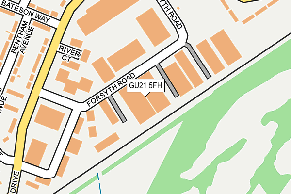
GU21 5FH is located in the Canalside electoral ward, within the local authority district of Woking and the English Parliamentary constituency of Woking. The Sub Integrated Care Board (ICB) Location is NHS Surrey Heartlands ICB - 92A and the police force is Surrey. This postcode has been in use since January 2017.


GetTheData
Source: OS OpenMap – Local (Ordnance Survey)
Source: OS VectorMap District (Ordnance Survey)
Licence: Open Government Licence (requires attribution)
| Easting | 502384 |
| Northing | 159952 |
| Latitude | 51.329458 |
| Longitude | -0.531849 |
GetTheData
Source: Open Postcode Geo
Licence: Open Government Licence
| Country | England |
| Postcode District | GU21 |
| ➜ GU21 open data dashboard ➜ See where GU21 is on a map ➜ Where is Sheerwater? | |
GetTheData
Source: Land Registry Price Paid Data
Licence: Open Government Licence
Elevation or altitude of GU21 5FH as distance above sea level:
| Metres | Feet | |
|---|---|---|
| Elevation | 30m | 98ft |
Elevation is measured from the approximate centre of the postcode, to the nearest point on an OS contour line from OS Terrain 50, which has contour spacing of ten vertical metres.
➜ How high above sea level am I? Find the elevation of your current position using your device's GPS.
GetTheData
Source: Open Postcode Elevation
Licence: Open Government Licence
| Ward | Canalside |
| Constituency | Woking |
GetTheData
Source: ONS Postcode Database
Licence: Open Government Licence
| January 2024 | Anti-social behaviour | On or near Perrin Court | 438m |
| January 2024 | Violence and sexual offences | On or near Perrin Court | 438m |
| December 2023 | Anti-social behaviour | On or near Perrin Court | 438m |
| ➜ Get more crime data in our Crime section | |||
GetTheData
Source: data.police.uk
Licence: Open Government Licence
| Forsyth Road (Albert Drive) | Sheerwater | 227m |
| Murray Green (Albert Drive) | Sheerwater | 238m |
| St Michael's Road (Albert Drive) | Sheerwater | 251m |
| Murray Green (Albert Drive) | Sheerwater | 254m |
| Forsyth Road (Albert Drive) | Sheerwater | 282m |
| Woking Station | 2.1km |
| West Byfleet Station | 2.1km |
| Byfleet & New Haw Station | 4.2km |
GetTheData
Source: NaPTAN
Licence: Open Government Licence
GetTheData
Source: ONS Postcode Database
Licence: Open Government Licence


➜ Get more ratings from the Food Standards Agency
GetTheData
Source: Food Standards Agency
Licence: FSA terms & conditions
| Last Collection | |||
|---|---|---|---|
| Location | Mon-Fri | Sat | Distance |
| Bateson Way | 17:00 | 12:00 | 236m |
| The Gateway | 17:15 | 11:45 | 505m |
| Sheerwater Post Office | 17:30 | 12:15 | 509m |
GetTheData
Source: Dracos
Licence: Creative Commons Attribution-ShareAlike
| Facility | Distance |
|---|---|
| New Monument Primary Academy Alpha Road, Woking Grass Pitches | 451m |
| Sheerwater Recreation Ground Hennessy Court, Woking Grass Pitches | 648m |
| Sheerwater Athletics Track (Closed) Blackmore Crescent, Woking Athletics | 669m |
GetTheData
Source: Active Places
Licence: Open Government Licence
| School | Phase of Education | Distance |
|---|---|---|
| New Monument Primary Academy Alpha Road, Maybury, Woking, GU22 8HA | Primary | 461m |
| Broadmere Primary Academy Devonshire Avenue, Sheerwater, Woking, GU21 5QE | Primary | 711m |
| The Bishop David Brown School Albert Drive, Woking, GU21 5RF | Secondary | 896m |
GetTheData
Source: Edubase
Licence: Open Government Licence
The below table lists the International Territorial Level (ITL) codes (formerly Nomenclature of Territorial Units for Statistics (NUTS) codes) and Local Administrative Units (LAU) codes for GU21 5FH:
| ITL 1 Code | Name |
|---|---|
| TLJ | South East (England) |
| ITL 2 Code | Name |
| TLJ2 | Surrey, East and West Sussex |
| ITL 3 Code | Name |
| TLJ25 | West Surrey |
| LAU 1 Code | Name |
| E07000217 | Woking |
GetTheData
Source: ONS Postcode Directory
Licence: Open Government Licence
The below table lists the Census Output Area (OA), Lower Layer Super Output Area (LSOA), and Middle Layer Super Output Area (MSOA) for GU21 5FH:
| Code | Name | |
|---|---|---|
| OA | E00157938 | |
| LSOA | E01030984 | Woking 004E |
| MSOA | E02006459 | Woking 004 |
GetTheData
Source: ONS Postcode Directory
Licence: Open Government Licence
| GU21 5SB | Forsyth Road | 108m |
| GU21 5LA | Albert Drive | 257m |
| GU21 5PB | Albert Drive | 261m |
| GU21 5LD | Bateson Way | 279m |
| GU21 5LB | Dykes Path | 285m |
| GU21 5PA | Murray Green | 298m |
| GU21 5QY | Albert Drive | 298m |
| GU21 5NU | Bunyard Drive | 312m |
| GU21 5QZ | Albert Drive | 318m |
| GU21 5LF | Bentham Avenue | 322m |
GetTheData
Source: Open Postcode Geo; Land Registry Price Paid Data
Licence: Open Government Licence