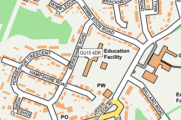
GU15 4DR is located in the Old Dean electoral ward, within the local authority district of Surrey Heath and the English Parliamentary constituency of Surrey Heath. The Sub Integrated Care Board (ICB) Location is NHS Frimley ICB - D4U1Y and the police force is Surrey. This postcode has been in use since January 1980.


GetTheData
Source: OS OpenMap – Local (Ordnance Survey)
Source: OS VectorMap District (Ordnance Survey)
Licence: Open Government Licence (requires attribution)
| Easting | 488897 |
| Northing | 161964 |
| Latitude | 51.349812 |
| Longitude | -0.724891 |
GetTheData
Source: Open Postcode Geo
Licence: Open Government Licence
| Country | England |
| Postcode District | GU15 |
| ➜ GU15 open data dashboard ➜ See where GU15 is on a map ➜ Where is Camberley? | |
GetTheData
Source: Land Registry Price Paid Data
Licence: Open Government Licence
Elevation or altitude of GU15 4DR as distance above sea level:
| Metres | Feet | |
|---|---|---|
| Elevation | 120m | 394ft |
Elevation is measured from the approximate centre of the postcode, to the nearest point on an OS contour line from OS Terrain 50, which has contour spacing of ten vertical metres.
➜ How high above sea level am I? Find the elevation of your current position using your device's GPS.
GetTheData
Source: Open Postcode Elevation
Licence: Open Government Licence
| Ward | Old Dean |
| Constituency | Surrey Heath |
GetTheData
Source: ONS Postcode Database
Licence: Open Government Licence
| November 2023 | Violence and sexual offences | On or near Kingston Road | 276m |
| November 2023 | Violence and sexual offences | On or near Kingston Road | 276m |
| November 2023 | Other crime | On or near Parking Area | 328m |
| ➜ Get more crime data in our Crime section | |||
GetTheData
Source: data.police.uk
Licence: Open Government Licence
| Berkshire Road | Old Dean | 63m |
| Wimbledon Close (Wimbledon Road) | Old Dean | 188m |
| Caesars Camp Road | Camberley | 202m |
| Collingwood College (Kingston Road) | Old Dean | 305m |
| Collingwood College (Kingston Road) | Old Dean | 308m |
| Camberley Station | 2km |
| Bagshot Station | 3km |
| Blackwater Station | 4.1km |
GetTheData
Source: NaPTAN
Licence: Open Government Licence
GetTheData
Source: ONS Postcode Database
Licence: Open Government Licence


➜ Get more ratings from the Food Standards Agency
GetTheData
Source: Food Standards Agency
Licence: FSA terms & conditions
| Last Collection | |||
|---|---|---|---|
| Location | Mon-Fri | Sat | Distance |
| Old Dean Post Office | 17:15 | 11:45 | 205m |
| Vale Road | 17:30 | 11:45 | 1,363m |
| Clarewood Drive | 17:30 | 12:15 | 1,557m |
GetTheData
Source: Dracos
Licence: Creative Commons Attribution-ShareAlike
| Facility | Distance |
|---|---|
| Cordwalles Junior School Berkshire Road, Camberley Grass Pitches | 0m |
| Collingwood College Kingston Road, Camberley Sports Hall, Grass Pitches | 223m |
| Old Dean Recreation Ground Wimbledon Road, Camberley Grass Pitches | 265m |
GetTheData
Source: Active Places
Licence: Open Government Licence
| School | Phase of Education | Distance |
|---|---|---|
| Cordwalles Junior School Berkshire Road, Old Dean Estate, Camberley, GU15 4DR | Primary | 0m |
| Collingwood College Kingston Road, Camberley, GU15 4AE | Secondary | 223m |
| Pine Ridge Infant School Esher Road, Camberley, GU15 4AL | Primary | 587m |
GetTheData
Source: Edubase
Licence: Open Government Licence
The below table lists the International Territorial Level (ITL) codes (formerly Nomenclature of Territorial Units for Statistics (NUTS) codes) and Local Administrative Units (LAU) codes for GU15 4DR:
| ITL 1 Code | Name |
|---|---|
| TLJ | South East (England) |
| ITL 2 Code | Name |
| TLJ2 | Surrey, East and West Sussex |
| ITL 3 Code | Name |
| TLJ25 | West Surrey |
| LAU 1 Code | Name |
| E07000214 | Surrey Heath |
GetTheData
Source: ONS Postcode Directory
Licence: Open Government Licence
The below table lists the Census Output Area (OA), Lower Layer Super Output Area (LSOA), and Middle Layer Super Output Area (MSOA) for GU15 4DR:
| Code | Name | |
|---|---|---|
| OA | E00156991 | |
| LSOA | E01030786 | Surrey Heath 004A |
| MSOA | E02006419 | Surrey Heath 004 |
GetTheData
Source: ONS Postcode Directory
Licence: Open Government Licence
| GU15 4DP | Berkshire Road | 89m |
| GU15 4DW | Hampshire Road | 94m |
| GU15 4AY | Wimbledon Road | 131m |
| GU15 4DT | Horseshoe Crescent | 136m |
| GU15 4DS | Horseshoe Crescent | 160m |
| GU15 4DG | Berkshire Road | 170m |
| GU15 4DN | Hampshire Road | 177m |
| GU15 4DQ | Dean Parade | 180m |
| GU15 4BQ | Bracknell Close | 188m |
| GU15 4AZ | Wimbledon Close | 189m |
GetTheData
Source: Open Postcode Geo; Land Registry Price Paid Data
Licence: Open Government Licence