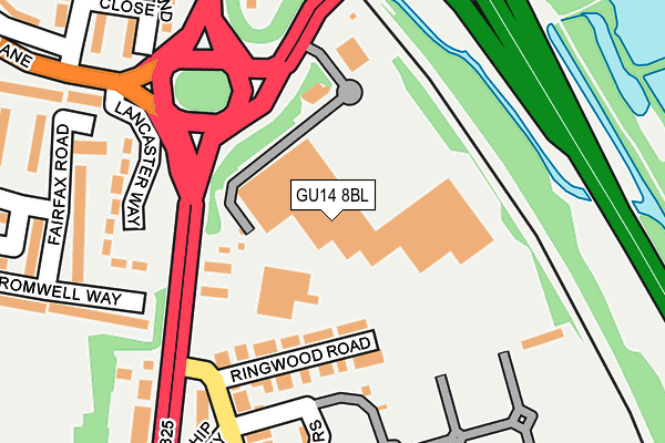
GU14 8BL is located in the Empress electoral ward, within the local authority district of Rushmoor and the English Parliamentary constituency of Aldershot. The Sub Integrated Care Board (ICB) Location is NHS Frimley ICB - D4U1Y and the police force is Hampshire. This postcode has been in use since December 1994.


GetTheData
Source: OS OpenMap – Local (Ordnance Survey)
Source: OS VectorMap District (Ordnance Survey)
Licence: Open Government Licence (requires attribution)
| Easting | 487318 |
| Northing | 157209 |
| Latitude | 51.307311 |
| Longitude | -0.748722 |
GetTheData
Source: Open Postcode Geo
Licence: Open Government Licence
| Country | England |
| Postcode District | GU14 |
| ➜ GU14 open data dashboard ➜ See where GU14 is on a map ➜ Where is Farnborough? | |
GetTheData
Source: Land Registry Price Paid Data
Licence: Open Government Licence
Elevation or altitude of GU14 8BL as distance above sea level:
| Metres | Feet | |
|---|---|---|
| Elevation | 70m | 230ft |
Elevation is measured from the approximate centre of the postcode, to the nearest point on an OS contour line from OS Terrain 50, which has contour spacing of ten vertical metres.
➜ How high above sea level am I? Find the elevation of your current position using your device's GPS.
GetTheData
Source: Open Postcode Elevation
Licence: Open Government Licence
| Ward | Empress |
| Constituency | Aldershot |
GetTheData
Source: ONS Postcode Database
Licence: Open Government Licence
| January 2024 | Violence and sexual offences | On or near Worcester Close | 489m |
| November 2023 | Possession of weapons | On or near Worcester Close | 489m |
| October 2023 | Burglary | On or near Worcester Close | 489m |
| ➜ Get more crime data in our Crime section | |||
GetTheData
Source: data.police.uk
Licence: Open Government Licence
| Bradfords Garage (Farnborough Road) | Farnborough Green | 131m |
| Bradfords Garage (Farnborough Road) | Farnborough Green | 145m |
| The Ship (Ship Lane) | Farnborough Green | 184m |
| Prospect Avenue (Farnborough Road) | Farnborough Green | 270m |
| Prince Charles Crescent (Hawley Lane) | Hawley Lane | 363m |
| Frimley Station | 0.5km |
| Farnborough North Station | 0.7km |
| Farnborough (Main) Station | 1.3km |
GetTheData
Source: NaPTAN
Licence: Open Government Licence
GetTheData
Source: ONS Postcode Database
Licence: Open Government Licence

➜ Get more ratings from the Food Standards Agency
GetTheData
Source: Food Standards Agency
Licence: FSA terms & conditions
| Last Collection | |||
|---|---|---|---|
| Location | Mon-Fri | Sat | Distance |
| Coleford Bridge Road | 17:00 | 11:45 | 297m |
| Mytchett Cross Roads | 17:00 | 11:45 | 363m |
| Prospect Avenue | 16:45 | 11:15 | 393m |
GetTheData
Source: Dracos
Licence: Creative Commons Attribution-ShareAlike
| Facility | Distance |
|---|---|
| Jd Gyms (Farnborough) Farnborough Gate, Farnborough Health and Fitness Gym | 78m |
| Farnborough Gate Sports Complex Ringwood Road, Farnborough Grass Pitches | 150m |
| The Sixth Form College Farnborough Prospect Avenue, Farnborough Sports Hall, Health and Fitness Gym, Artificial Grass Pitch, Grass Pitches, Studio | 580m |
GetTheData
Source: Active Places
Licence: Open Government Licence
| School | Phase of Education | Distance |
|---|---|---|
| The Sixth Form College Farnborough Prospect Avenue, Farnborough, GU14 8JX | 16 plus | 576m |
| Henry Tyndale School Ship Lane, Farnborough, GU14 8BX | Not applicable | 639m |
| Farnborough Hill Farnborough Road, Farnborough, GU14 8AT | Not applicable | 753m |
GetTheData
Source: Edubase
Licence: Open Government Licence
The below table lists the International Territorial Level (ITL) codes (formerly Nomenclature of Territorial Units for Statistics (NUTS) codes) and Local Administrative Units (LAU) codes for GU14 8BL:
| ITL 1 Code | Name |
|---|---|
| TLJ | South East (England) |
| ITL 2 Code | Name |
| TLJ3 | Hampshire and Isle of Wight |
| ITL 3 Code | Name |
| TLJ37 | North Hampshire |
| LAU 1 Code | Name |
| E07000092 | Rushmoor |
GetTheData
Source: ONS Postcode Directory
Licence: Open Government Licence
The below table lists the Census Output Area (OA), Lower Layer Super Output Area (LSOA), and Middle Layer Super Output Area (MSOA) for GU14 8BL:
| Code | Name | |
|---|---|---|
| OA | E00117402 | |
| LSOA | E01023103 | Rushmoor 004C |
| MSOA | E02004805 | Rushmoor 004 |
GetTheData
Source: ONS Postcode Directory
Licence: Open Government Licence
| GU14 8BG | Ringwood Road | 106m |
| GU14 8BE | Ship Lane | 173m |
| GU14 8JA | Lancaster Way | 197m |
| GU14 8DA | Mariners Drive | 234m |
| GU14 8LW | Cromwell Way | 244m |
| GU14 8BQ | Ship Alley | 247m |
| GU14 8DH | Buckland Close | 256m |
| GU14 8AW | Farnborough Road | 259m |
| GU14 8BJ | Ship Lane | 273m |
| GU14 8BA | Farnborough Road | 274m |
GetTheData
Source: Open Postcode Geo; Land Registry Price Paid Data
Licence: Open Government Licence