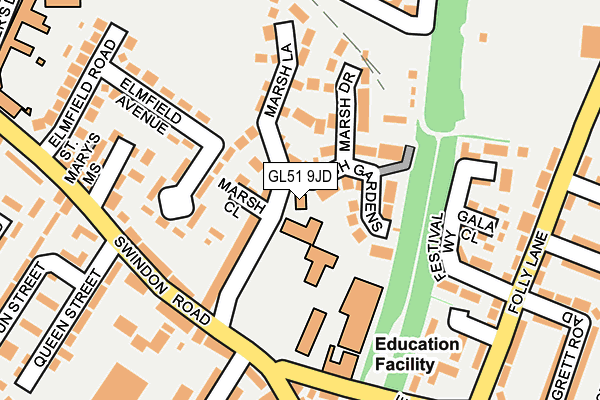
GL51 9JD is located in the St Paul's electoral ward, within the local authority district of Cheltenham and the English Parliamentary constituency of Cheltenham. The Sub Integrated Care Board (ICB) Location is NHS Gloucestershire ICB - 11M and the police force is Gloucestershire. This postcode has been in use since January 1980.


GetTheData
Source: OS OpenMap – Local (Ordnance Survey)
Source: OS VectorMap District (Ordnance Survey)
Licence: Open Government Licence (requires attribution)
| Easting | 394323 |
| Northing | 223448 |
| Latitude | 51.909537 |
| Longitude | -2.083933 |
GetTheData
Source: Open Postcode Geo
Licence: Open Government Licence
| Country | England |
| Postcode District | GL51 |
| ➜ GL51 open data dashboard ➜ See where GL51 is on a map ➜ Where is Cheltenham? | |
GetTheData
Source: Land Registry Price Paid Data
Licence: Open Government Licence
Elevation or altitude of GL51 9JD as distance above sea level:
| Metres | Feet | |
|---|---|---|
| Elevation | 50m | 164ft |
Elevation is measured from the approximate centre of the postcode, to the nearest point on an OS contour line from OS Terrain 50, which has contour spacing of ten vertical metres.
➜ How high above sea level am I? Find the elevation of your current position using your device's GPS.
GetTheData
Source: Open Postcode Elevation
Licence: Open Government Licence
| Ward | St Paul's |
| Constituency | Cheltenham |
GetTheData
Source: ONS Postcode Database
Licence: Open Government Licence
| January 2024 | Bicycle theft | On or near Parking Area | 331m |
| January 2024 | Other theft | On or near Parking Area | 331m |
| January 2024 | Violence and sexual offences | On or near Parking Area | 331m |
| ➜ Get more crime data in our Crime section | |||
GetTheData
Source: data.police.uk
Licence: Open Government Licence
| Hardwick Campus (Swindon Road) | Cheltenham | 153m |
| Hardwick Campus (Swindon Road) | Cheltenham | 159m |
| Manser Street (Folly Lane) | Cheltenham | 234m |
| Folly Lane (Saint Paul's Road) | Cheltenham | 237m |
| Gardners Lane School (Swindon Road) | Cheltenham | 242m |
| Cheltenham Spa Station | 1.7km |
GetTheData
Source: NaPTAN
Licence: Open Government Licence
GetTheData
Source: ONS Postcode Database
Licence: Open Government Licence


➜ Get more ratings from the Food Standards Agency
GetTheData
Source: Food Standards Agency
Licence: FSA terms & conditions
| Last Collection | |||
|---|---|---|---|
| Location | Mon-Fri | Sat | Distance |
| Swindon Road | 17:15 | 12:15 | 174m |
| Swindon Road Delivery Office | 19:00 | 13:00 | 452m |
| Tesco Tewkesbury Road | 17:00 | 12:45 | 481m |
GetTheData
Source: Dracos
Licence: Creative Commons Attribution-ShareAlike
| Facility | Distance |
|---|---|
| Unisport (Hardwick) (Closed) St. Pauls Road, Cheltenham Sports Hall, Studio, Swimming Pool, Health and Fitness Gym | 129m |
| Elmfield Park Elmfield Road, Elmfield Road, Cheltenham Grass Pitches | 287m |
| Gardners Lane Primary School Gardners Lane, Gardners Lane, Cheltenham Grass Pitches | 293m |
GetTheData
Source: Active Places
Licence: Open Government Licence
| School | Phase of Education | Distance |
|---|---|---|
| Gardners Lane Primary School Gardners Lane, Swindon Road, Cheltenham, GL51 9JW | Primary | 293m |
| Gloucester Road Primary School Gloucester Road, Cheltenham, GL51 8PB | Primary | 699m |
| The Catholic School of Saint Gregory the Great St James Square, Cheltenham, GL50 3QG | Primary | 815m |
GetTheData
Source: Edubase
Licence: Open Government Licence
The below table lists the International Territorial Level (ITL) codes (formerly Nomenclature of Territorial Units for Statistics (NUTS) codes) and Local Administrative Units (LAU) codes for GL51 9JD:
| ITL 1 Code | Name |
|---|---|
| TLK | South West (England) |
| ITL 2 Code | Name |
| TLK1 | Gloucestershire, Wiltshire and Bath/Bristol area |
| ITL 3 Code | Name |
| TLK13 | Gloucestershire CC |
| LAU 1 Code | Name |
| E07000078 | Cheltenham |
GetTheData
Source: ONS Postcode Directory
Licence: Open Government Licence
The below table lists the Census Output Area (OA), Lower Layer Super Output Area (LSOA), and Middle Layer Super Output Area (MSOA) for GL51 9JD:
| Code | Name | |
|---|---|---|
| OA | E00112566 | |
| LSOA | E01022151 | Cheltenham 004B |
| MSOA | E02004603 | Cheltenham 004 |
GetTheData
Source: ONS Postcode Directory
Licence: Open Government Licence
| GL51 9JB | Marsh Lane | 54m |
| GL51 9LD | Marsh Close | 59m |
| GL51 9LL | Marsh Gardens | 65m |
| GL51 9JF | Midwinter Avenue | 100m |
| GL51 9JE | Marsh Lane | 115m |
| GL51 9LN | Marsh Drive | 120m |
| GL51 9HZ | Swindon Road | 166m |
| GL51 9HX | Swindon Road | 166m |
| GL51 9JQ | Elmfield Avenue | 171m |
| GL51 9JG | Elmfield Avenue | 176m |
GetTheData
Source: Open Postcode Geo; Land Registry Price Paid Data
Licence: Open Government Licence