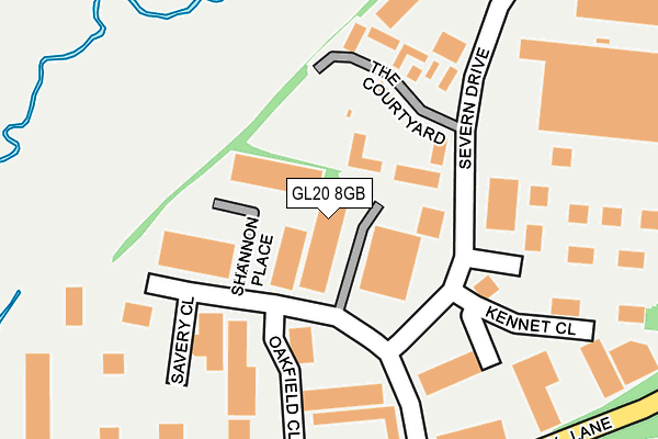
GL20 8GB is located in the Tewkesbury East electoral ward, within the local authority district of Tewkesbury and the English Parliamentary constituency of Tewkesbury. The Sub Integrated Care Board (ICB) Location is NHS Gloucestershire ICB - 11M and the police force is Gloucestershire. This postcode has been in use since January 2010.


GetTheData
Source: OS OpenMap – Local (Ordnance Survey)
Source: OS VectorMap District (Ordnance Survey)
Licence: Open Government Licence (requires attribution)
| Easting | 391312 |
| Northing | 233971 |
| Latitude | 52.004116 |
| Longitude | -2.127965 |
GetTheData
Source: Open Postcode Geo
Licence: Open Government Licence
| Country | England |
| Postcode District | GL20 |
| ➜ GL20 open data dashboard ➜ See where GL20 is on a map ➜ Where is Tewkesbury? | |
GetTheData
Source: Land Registry Price Paid Data
Licence: Open Government Licence
Elevation or altitude of GL20 8GB as distance above sea level:
| Metres | Feet | |
|---|---|---|
| Elevation | 20m | 66ft |
Elevation is measured from the approximate centre of the postcode, to the nearest point on an OS contour line from OS Terrain 50, which has contour spacing of ten vertical metres.
➜ How high above sea level am I? Find the elevation of your current position using your device's GPS.
GetTheData
Source: Open Postcode Elevation
Licence: Open Government Licence
| Ward | Tewkesbury East |
| Constituency | Tewkesbury |
GetTheData
Source: ONS Postcode Database
Licence: Open Government Licence
| June 2022 | Robbery | On or near Beta Close | 368m |
| May 2022 | Violence and sexual offences | On or near The Courtyard | 189m |
| May 2022 | Violence and sexual offences | On or near The Courtyard | 189m |
| ➜ Get more crime data in our Crime section | |||
GetTheData
Source: data.police.uk
Licence: Open Government Licence
| Business Centre (Shannon Way) | Newtown | 327m |
| Business Centre (Shannon Way) | Newtown | 461m |
| Long Eights (The Park) | Northway | 564m |
| Long Eights (The Park) | Northway | 568m |
| The Park School Stop | Northway | 570m |
| Ashchurch for Tewkesbury Station | 1.4km |
GetTheData
Source: NaPTAN
Licence: Open Government Licence
GetTheData
Source: ONS Postcode Database
Licence: Open Government Licence


➜ Get more ratings from the Food Standards Agency
GetTheData
Source: Food Standards Agency
Licence: FSA terms & conditions
| Last Collection | |||
|---|---|---|---|
| Location | Mon-Fri | Sat | Distance |
| Delivery Office, Kennet Close | 18:00 | 12:30 | 159m |
| Kingston Road | 17:15 | 11:30 | 670m |
| The Park | 17:15 | 11:30 | 818m |
GetTheData
Source: Dracos
Licence: Creative Commons Attribution-ShareAlike
| Facility | Distance |
|---|---|
| Avonside Gym And Fitness Centre (Closed) Green Lane, Tewkesbury Health and Fitness Gym | 426m |
| Northway Playing Field Northway Lane, Tewkesbury Grass Pitches | 500m |
| Alderman Knight School Ashchurch Road, Tewkesbury Grass Pitches, Sports Hall | 867m |
GetTheData
Source: Active Places
Licence: Open Government Licence
| School | Phase of Education | Distance |
|---|---|---|
| Norton College Tewkesbury International Way, Tewkesbury, Gloucestershire, GL20 8UQ | Not applicable | 400m |
| Alderman Knight School Ashchurch Road, Tewkesbury, GL20 8JJ | Not applicable | 867m |
| Tewkesbury Academy Ashchurch Road, Tewkesbury, GL20 8DF | Secondary | 944m |
GetTheData
Source: Edubase
Licence: Open Government Licence
The below table lists the International Territorial Level (ITL) codes (formerly Nomenclature of Territorial Units for Statistics (NUTS) codes) and Local Administrative Units (LAU) codes for GL20 8GB:
| ITL 1 Code | Name |
|---|---|
| TLK | South West (England) |
| ITL 2 Code | Name |
| TLK1 | Gloucestershire, Wiltshire and Bath/Bristol area |
| ITL 3 Code | Name |
| TLK13 | Gloucestershire CC |
| LAU 1 Code | Name |
| E07000083 | Tewkesbury |
GetTheData
Source: ONS Postcode Directory
Licence: Open Government Licence
The below table lists the Census Output Area (OA), Lower Layer Super Output Area (LSOA), and Middle Layer Super Output Area (MSOA) for GL20 8GB:
| Code | Name | |
|---|---|---|
| OA | E00114172 | |
| LSOA | E01022455 | Tewkesbury 001E |
| MSOA | E02004666 | Tewkesbury 001 |
GetTheData
Source: ONS Postcode Directory
Licence: Open Government Licence
| GL20 8SL | Shannon Place | 35m |
| GL20 8PF | Oakfield Close | 116m |
| GL20 8GD | The Courtyard | 179m |
| GL20 8SD | Hardwicke Bank Road | 181m |
| GL20 8HF | Kennet Close | 235m |
| GL20 8DN | Severn Drive | 253m |
| GL20 8SF | Severn Drive | 317m |
| GL20 8SR | Tewkesbury Business Centre | 339m |
| GL20 8ND | Shannon Way | 537m |
| GL20 8ST | Tawny Close | 544m |
GetTheData
Source: Open Postcode Geo; Land Registry Price Paid Data
Licence: Open Government Licence