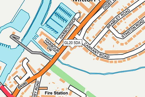
GL20 5DA lies on Bredon Road in Tewkesbury. GL20 5DA is located in the Tewkesbury North & Twyning electoral ward, within the local authority district of Tewkesbury and the English Parliamentary constituency of Tewkesbury. The Sub Integrated Care Board (ICB) Location is NHS Gloucestershire ICB - 11M and the police force is Gloucestershire. This postcode has been in use since January 1980.


GetTheData
Source: OS OpenMap – Local (Ordnance Survey)
Source: OS VectorMap District (Ordnance Survey)
Licence: Open Government Licence (requires attribution)
| Easting | 389680 |
| Northing | 233379 |
| Latitude | 51.998756 |
| Longitude | -2.151728 |
GetTheData
Source: Open Postcode Geo
Licence: Open Government Licence
| Street | Bredon Road |
| Town/City | Tewkesbury |
| Country | England |
| Postcode District | GL20 |
➜ See where GL20 is on a map ➜ Where is Tewkesbury? | |
GetTheData
Source: Land Registry Price Paid Data
Licence: Open Government Licence
Elevation or altitude of GL20 5DA as distance above sea level:
| Metres | Feet | |
|---|---|---|
| Elevation | 10m | 33ft |
Elevation is measured from the approximate centre of the postcode, to the nearest point on an OS contour line from OS Terrain 50, which has contour spacing of ten vertical metres.
➜ How high above sea level am I? Find the elevation of your current position using your device's GPS.
GetTheData
Source: Open Postcode Elevation
Licence: Open Government Licence
| Ward | Tewkesbury North & Twyning |
| Constituency | Tewkesbury |
GetTheData
Source: ONS Postcode Database
Licence: Open Government Licence
MEADOWCROFT, BREDON ROAD, TEWKESBURY, GL20 5DA 2014 31 JAN £395,000 |
GetTheData
Source: HM Land Registry Price Paid Data
Licence: Contains HM Land Registry data © Crown copyright and database right 2025. This data is licensed under the Open Government Licence v3.0.
| Digby Drive (Carrant Road) | Mitton | 46m |
| Harbourside | Mitton | 53m |
| Harbour View | Mitton | 54m |
| Allotments (Digby Drive) | Mitton | 255m |
| Carrant Road | Mitton | 286m |
| Ashchurch for Tewkesbury Station | 3km |
GetTheData
Source: NaPTAN
Licence: Open Government Licence
| Percentage of properties with Next Generation Access | 100.0% |
| Percentage of properties with Superfast Broadband | 100.0% |
| Percentage of properties with Ultrafast Broadband | 0.0% |
| Percentage of properties with Full Fibre Broadband | 0.0% |
Superfast Broadband is between 30Mbps and 300Mbps
Ultrafast Broadband is > 300Mbps
| Percentage of properties unable to receive 2Mbps | 0.0% |
| Percentage of properties unable to receive 5Mbps | 0.0% |
| Percentage of properties unable to receive 10Mbps | 0.0% |
| Percentage of properties unable to receive 30Mbps | 0.0% |
GetTheData
Source: Ofcom
Licence: Ofcom Terms of Use (requires attribution)
GetTheData
Source: ONS Postcode Database
Licence: Open Government Licence


➜ Get more ratings from the Food Standards Agency
GetTheData
Source: Food Standards Agency
Licence: FSA terms & conditions
| Last Collection | |||
|---|---|---|---|
| Location | Mon-Fri | Sat | Distance |
| Carrant Road | 17:15 | 12:00 | 71m |
| Tewkesbury Post Office | 17:30 | 12:30 | 425m |
| Tewkesbury Po #2 | 17:30 | 12:30 | 425m |
GetTheData
Source: Dracos
Licence: Creative Commons Attribution-ShareAlike
| Risk of GL20 5DA flooding from rivers and sea | Medium |
| ➜ GL20 5DA flood map | |
GetTheData
Source: Open Flood Risk by Postcode
Licence: Open Government Licence
The below table lists the International Territorial Level (ITL) codes (formerly Nomenclature of Territorial Units for Statistics (NUTS) codes) and Local Administrative Units (LAU) codes for GL20 5DA:
| ITL 1 Code | Name |
|---|---|
| TLK | South West (England) |
| ITL 2 Code | Name |
| TLK1 | Gloucestershire, Wiltshire and Bath/Bristol area |
| ITL 3 Code | Name |
| TLK13 | Gloucestershire CC |
| LAU 1 Code | Name |
| E07000083 | Tewkesbury |
GetTheData
Source: ONS Postcode Directory
Licence: Open Government Licence
The below table lists the Census Output Area (OA), Lower Layer Super Output Area (LSOA), and Middle Layer Super Output Area (MSOA) for GL20 5DA:
| Code | Name | |
|---|---|---|
| OA | E00114204 | |
| LSOA | E01022461 | Tewkesbury 002F |
| MSOA | E02004667 | Tewkesbury 002 |
GetTheData
Source: ONS Postcode Directory
Licence: Open Government Licence
| GL20 5DT | Harbourside | 76m |
| GL20 5AZ | Harbour View | 112m |
| GL20 8AH | Digby Drive | 151m |
| GL20 8AG | Bramley Road | 166m |
| GL20 5DY | Workman Close | 179m |
| GL20 5NG | Jeynes Row | 218m |
| GL20 5DX | Paternosters | 222m |
| GL20 5BT | Twixtbears | 226m |
| GL20 5AY | Trafalgar Road | 228m |
| GL20 5NY | Oldbury Road | 229m |
GetTheData
Source: Open Postcode Geo; Land Registry Price Paid Data
Licence: Open Government Licence