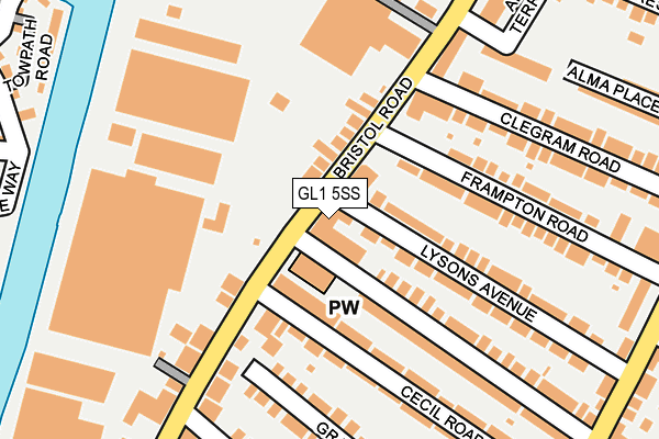
GL1 5SS is located in the Moreland electoral ward, within the local authority district of Gloucester and the English Parliamentary constituency of Gloucester. The Sub Integrated Care Board (ICB) Location is NHS Gloucestershire ICB - 11M and the police force is Gloucestershire. This postcode has been in use since January 1980.


GetTheData
Source: OS OpenMap – Local (Ordnance Survey)
Source: OS VectorMap District (Ordnance Survey)
Licence: Open Government Licence (requires attribution)
| Easting | 382509 |
| Northing | 217145 |
| Latitude | 51.852619 |
| Longitude | -2.255348 |
GetTheData
Source: Open Postcode Geo
Licence: Open Government Licence
| Country | England |
| Postcode District | GL1 |
➜ See where GL1 is on a map ➜ Where is Gloucester? | |
GetTheData
Source: Land Registry Price Paid Data
Licence: Open Government Licence
Elevation or altitude of GL1 5SS as distance above sea level:
| Metres | Feet | |
|---|---|---|
| Elevation | 20m | 66ft |
Elevation is measured from the approximate centre of the postcode, to the nearest point on an OS contour line from OS Terrain 50, which has contour spacing of ten vertical metres.
➜ How high above sea level am I? Find the elevation of your current position using your device's GPS.
GetTheData
Source: Open Postcode Elevation
Licence: Open Government Licence
| Ward | Moreland |
| Constituency | Gloucester |
GetTheData
Source: ONS Postcode Database
Licence: Open Government Licence
| Tesco Express (Bristol Road) | Gloucester | 20m |
| Tesco Express (Bristol Road) | Gloucester | 30m |
| Frampton Road (Bristol Road) | Gloucester | 117m |
| Granville Street (Bristol Road) | Gloucester | 126m |
| Granville Street (Bristol Road) | Gloucester | 166m |
| Gloucester Station | 1.8km |
GetTheData
Source: NaPTAN
Licence: Open Government Licence
GetTheData
Source: ONS Postcode Database
Licence: Open Government Licence


➜ Get more ratings from the Food Standards Agency
GetTheData
Source: Food Standards Agency
Licence: FSA terms & conditions
| Last Collection | |||
|---|---|---|---|
| Location | Mon-Fri | Sat | Distance |
| Bristol Road | 17:40 | 12:30 | 252m |
| Linden Road P.o. | 17:30 | 12:30 | 326m |
| Bristol Road | 17:45 | 12:30 | 446m |
GetTheData
Source: Dracos
Licence: Creative Commons Attribution-ShareAlike
| Risk of GL1 5SS flooding from rivers and sea | Low |
| ➜ GL1 5SS flood map | |
GetTheData
Source: Open Flood Risk by Postcode
Licence: Open Government Licence
The below table lists the International Territorial Level (ITL) codes (formerly Nomenclature of Territorial Units for Statistics (NUTS) codes) and Local Administrative Units (LAU) codes for GL1 5SS:
| ITL 1 Code | Name |
|---|---|
| TLK | South West (England) |
| ITL 2 Code | Name |
| TLK1 | Gloucestershire, Wiltshire and Bath/Bristol area |
| ITL 3 Code | Name |
| TLK13 | Gloucestershire CC |
| LAU 1 Code | Name |
| E07000081 | Gloucester |
GetTheData
Source: ONS Postcode Directory
Licence: Open Government Licence
The below table lists the Census Output Area (OA), Lower Layer Super Output Area (LSOA), and Middle Layer Super Output Area (MSOA) for GL1 5SS:
| Code | Name | |
|---|---|---|
| OA | E00113502 | |
| LSOA | E01022326 | Gloucester 009A |
| MSOA | E02004644 | Gloucester 009 |
GetTheData
Source: ONS Postcode Directory
Licence: Open Government Licence
| GL1 5SR | Bristol Road | 40m |
| GL1 5QE | Lysons Avenue | 141m |
| GL1 5QF | Lysons Avenue | 151m |
| GL1 5QB | Frampton Road | 160m |
| GL1 5HG | Cecil Road | 173m |
| GL1 5TA | Bristol Road | 177m |
| GL1 5HL | Granville Street | 181m |
| GL1 5HQ | Cecil Road | 181m |
| GL1 5HB | Linden Road | 181m |
| GL1 5TG | Bristol Road | 183m |
GetTheData
Source: Open Postcode Geo; Land Registry Price Paid Data
Licence: Open Government Licence