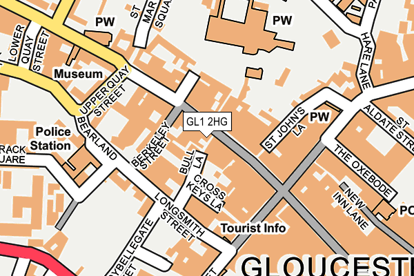
GL1 2HG lies on Bull Lane in Gloucester. GL1 2HG is located in the Westgate electoral ward, within the local authority district of Gloucester and the English Parliamentary constituency of Gloucester. The Sub Integrated Care Board (ICB) Location is NHS Gloucestershire ICB - 11M and the police force is Gloucestershire. This postcode has been in use since January 1980.


GetTheData
Source: OS OpenMap – Local (Ordnance Survey)
Source: OS VectorMap District (Ordnance Survey)
Licence: Open Government Licence (requires attribution)
| Easting | 383060 |
| Northing | 218633 |
| Latitude | 51.866022 |
| Longitude | -2.247418 |
GetTheData
Source: Open Postcode Geo
Licence: Open Government Licence
| Street | Bull Lane |
| Town/City | Gloucester |
| Country | England |
| Postcode District | GL1 |
| ➜ GL1 open data dashboard ➜ See where GL1 is on a map ➜ Where is Gloucester? | |
GetTheData
Source: Land Registry Price Paid Data
Licence: Open Government Licence
Elevation or altitude of GL1 2HG as distance above sea level:
| Metres | Feet | |
|---|---|---|
| Elevation | 20m | 66ft |
Elevation is measured from the approximate centre of the postcode, to the nearest point on an OS contour line from OS Terrain 50, which has contour spacing of ten vertical metres.
➜ How high above sea level am I? Find the elevation of your current position using your device's GPS.
GetTheData
Source: Open Postcode Elevation
Licence: Open Government Licence
| Ward | Westgate |
| Constituency | Gloucester |
GetTheData
Source: ONS Postcode Database
Licence: Open Government Licence
| January 2024 | Anti-social behaviour | On or near Shopping Area | 310m |
| January 2024 | Burglary | On or near Shopping Area | 310m |
| January 2024 | Criminal damage and arson | On or near Shopping Area | 310m |
| ➜ Bull Lane crime map and outcomes | |||
GetTheData
Source: data.police.uk
Licence: Open Government Licence
| Blackfriars Priory (Ladybellegate Street) | Gloucester | 146m |
| New County Hotel (Southgate Street) | Gloucester | 199m |
| New County Hotel (Southgate Street) | Gloucester | 206m |
| St Nicholas' Church (Westgate Street) | Gloucester | 244m |
| Lower Quay Street (Quay Street) | Gloucester | 276m |
| Gloucester Station | 0.6km |
GetTheData
Source: NaPTAN
Licence: Open Government Licence
| Percentage of properties with Next Generation Access | 100.0% |
| Percentage of properties with Superfast Broadband | 100.0% |
| Percentage of properties with Ultrafast Broadband | 100.0% |
| Percentage of properties with Full Fibre Broadband | 0.0% |
Superfast Broadband is between 30Mbps and 300Mbps
Ultrafast Broadband is > 300Mbps
| Percentage of properties unable to receive 2Mbps | 0.0% |
| Percentage of properties unable to receive 5Mbps | 0.0% |
| Percentage of properties unable to receive 10Mbps | 0.0% |
| Percentage of properties unable to receive 30Mbps | 0.0% |
GetTheData
Source: Ofcom
Licence: Ofcom Terms of Use (requires attribution)
GetTheData
Source: ONS Postcode Database
Licence: Open Government Licence


➜ Get more ratings from the Food Standards Agency
GetTheData
Source: Food Standards Agency
Licence: FSA terms & conditions
| Last Collection | |||
|---|---|---|---|
| Location | Mon-Fri | Sat | Distance |
| College Green | 18:30 | 12:30 | 117m |
| Southgate Street | 18:30 | 12:30 | 160m |
| Hare Lane | 18:30 | 12:30 | 248m |
GetTheData
Source: Dracos
Licence: Creative Commons Attribution-ShareAlike
| Facility | Distance |
|---|---|
| Anytime Fitness (Gloucester) Northgate Street, Northgate Street, Gloucester Health and Fitness Gym | 145m |
| The Kings School Gloucester Pitt Street, Gloucester Grass Pitches, Sports Hall, Studio | 301m |
| The Kings School (Archdeacon Meadow Sports Ground) St Oswalds Road, Gloucester Grass Pitches, Artificial Grass Pitch | 569m |
GetTheData
Source: Active Places
Licence: Open Government Licence
| School | Phase of Education | Distance |
|---|---|---|
| The King's School, Gloucester Pitt Street, Gloucester, GL1 2BG | Not applicable | 301m |
| Kingsholm Church of England Primary School Guinea Street, Gloucester, GL1 3BN | Primary | 730m |
| Edward Jenner School The Elms, 44 London Road, Gloucester, Gloucester, GL1 3NZ | Not applicable | 799m |
GetTheData
Source: Edubase
Licence: Open Government Licence
The below table lists the International Territorial Level (ITL) codes (formerly Nomenclature of Territorial Units for Statistics (NUTS) codes) and Local Administrative Units (LAU) codes for GL1 2HG:
| ITL 1 Code | Name |
|---|---|
| TLK | South West (England) |
| ITL 2 Code | Name |
| TLK1 | Gloucestershire, Wiltshire and Bath/Bristol area |
| ITL 3 Code | Name |
| TLK13 | Gloucestershire CC |
| LAU 1 Code | Name |
| E07000081 | Gloucester |
GetTheData
Source: ONS Postcode Directory
Licence: Open Government Licence
The below table lists the Census Output Area (OA), Lower Layer Super Output Area (LSOA), and Middle Layer Super Output Area (MSOA) for GL1 2HG:
| Code | Name | |
|---|---|---|
| OA | E00113597 | |
| LSOA | E01032937 | Gloucester 004F |
| MSOA | E02004639 | Gloucester 004 |
GetTheData
Source: ONS Postcode Directory
Licence: Open Government Licence
| GL1 2NW | Westgate Street | 21m |
| GL1 2NF | Westgate Street | 49m |
| GL1 2NJ | College Court | 62m |
| GL1 2NG | Westgate Street | 65m |
| GL1 2JB | Berkeley Street | 86m |
| GL1 2DH | Southgate Street | 115m |
| GL1 2NZ | Westgate Street | 117m |
| GL1 2HQ | Cross Keys Lane | 119m |
| GL1 2HT | Longsmith Street | 132m |
| GL1 2DP | Southgate Street | 142m |
GetTheData
Source: Open Postcode Geo; Land Registry Price Paid Data
Licence: Open Government Licence