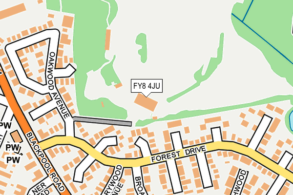
FY8 4JU is located in the Park electoral ward, within the local authority district of Fylde and the English Parliamentary constituency of Fylde. The Sub Integrated Care Board (ICB) Location is NHS Lancashire and South Cumbria ICB - 02M and the police force is Lancashire. This postcode has been in use since January 1980.


GetTheData
Source: OS OpenMap – Local (Ordnance Survey)
Source: OS VectorMap District (Ordnance Survey)
Licence: Open Government Licence (requires attribution)
| Easting | 335252 |
| Northing | 427818 |
| Latitude | 53.742716 |
| Longitude | -2.983190 |
GetTheData
Source: Open Postcode Geo
Licence: Open Government Licence
| Country | England |
| Postcode District | FY8 |
| ➜ FY8 open data dashboard ➜ See where FY8 is on a map ➜ Where is Lytham St Anne's? | |
GetTheData
Source: Land Registry Price Paid Data
Licence: Open Government Licence
Elevation or altitude of FY8 4JU as distance above sea level:
| Metres | Feet | |
|---|---|---|
| Elevation | 10m | 33ft |
Elevation is measured from the approximate centre of the postcode, to the nearest point on an OS contour line from OS Terrain 50, which has contour spacing of ten vertical metres.
➜ How high above sea level am I? Find the elevation of your current position using your device's GPS.
GetTheData
Source: Open Postcode Elevation
Licence: Open Government Licence
| Ward | Park |
| Constituency | Fylde |
GetTheData
Source: ONS Postcode Database
Licence: Open Government Licence
| June 2022 | Anti-social behaviour | On or near Milner Road | 317m |
| June 2022 | Violence and sexual offences | On or near Milner Road | 317m |
| June 2022 | Anti-social behaviour | On or near Gloucester Road | 478m |
| ➜ Get more crime data in our Crime section | |||
GetTheData
Source: data.police.uk
Licence: Open Government Licence
| Fernwood Close (Forest Drive) | Ansdell | 113m |
| Fernwood Close (Forest Drive) | Ansdell | 125m |
| Greenwood Close (Forest Drive) | Ansdell | 150m |
| Greenwood Close (Forest Drive) | Ansdell | 155m |
| Milner Road | Ansdell | 239m |
| Ansdell & Fairhaven Station | 0.7km |
| Lytham Station | 1.3km |
| St Annes-on-the-Sea Station | 3.2km |
GetTheData
Source: NaPTAN
Licence: Open Government Licence
GetTheData
Source: ONS Postcode Database
Licence: Open Government Licence


➜ Get more ratings from the Food Standards Agency
GetTheData
Source: Food Standards Agency
Licence: FSA terms & conditions
| Last Collection | |||
|---|---|---|---|
| Location | Mon-Fri | Sat | Distance |
| 17 Cambridge Road, Ansdell | 17:15 | 11:30 | 403m |
| Ansdell Post Office | 17:15 | 11:30 | 540m |
| Sedwell Close | 16:00 | 11:30 | 599m |
GetTheData
Source: Dracos
Licence: Creative Commons Attribution-ShareAlike
| Facility | Distance |
|---|---|
| Fairhaven Golf Club Oakwood Avenue, Lytham St. Annes Golf | 0m |
| Fylde Rufc Blackpool Road, Lytham St. Annes Grass Pitches, Health and Fitness Gym, Artificial Grass Pitch | 335m |
| Lytham Football Pitch (Closed) Cambridge Road, Lytham St. Annes Grass Pitches | 443m |
GetTheData
Source: Active Places
Licence: Open Government Licence
| School | Phase of Education | Distance |
|---|---|---|
| Lytham Hall Park Primary School South Park, Lytham, Lytham St Annes, FY8 4QU | Primary | 714m |
| Ansdell Primary School Lansdowne Road, Ansdell, Lytham St Annes, FY8 4DR | Primary | 850m |
| Lytham St Annes High School Albany Road, Lytham St. Annes, FY8 4GW | Secondary | 1.1km |
GetTheData
Source: Edubase
Licence: Open Government Licence
The below table lists the International Territorial Level (ITL) codes (formerly Nomenclature of Territorial Units for Statistics (NUTS) codes) and Local Administrative Units (LAU) codes for FY8 4JU:
| ITL 1 Code | Name |
|---|---|
| TLD | North West (England) |
| ITL 2 Code | Name |
| TLD4 | Lancashire |
| ITL 3 Code | Name |
| TLD45 | Mid Lancashire |
| LAU 1 Code | Name |
| E07000119 | Fylde |
GetTheData
Source: ONS Postcode Directory
Licence: Open Government Licence
The below table lists the Census Output Area (OA), Lower Layer Super Output Area (LSOA), and Middle Layer Super Output Area (MSOA) for FY8 4JU:
| Code | Name | |
|---|---|---|
| OA | E00126798 | |
| LSOA | E01024981 | Fylde 008A |
| MSOA | E02005210 | Fylde 008 |
GetTheData
Source: ONS Postcode Directory
Licence: Open Government Licence
| FY8 4PE | Rosewood Close | 58m |
| FY8 4RL | Thornwood Close | 71m |
| FY8 4PD | Cedarwood Close | 103m |
| FY8 4RA | Ashwood Close | 138m |
| FY8 4RD | Fernwood Close | 160m |
| FY8 4PF | Forest Drive | 173m |
| FY8 4RE | Kingswood Close | 181m |
| FY8 4PB | Oakwood Avenue | 190m |
| FY8 4PG | Greenwood Close | 191m |
| FY8 4PJ | Cherrywood Avenue | 203m |
GetTheData
Source: Open Postcode Geo; Land Registry Price Paid Data
Licence: Open Government Licence