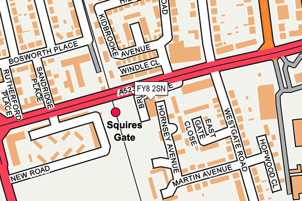
FY8 2SN is located in the Kilgrimol electoral ward, within the local authority district of Fylde and the English Parliamentary constituency of Fylde. The Sub Integrated Care Board (ICB) Location is NHS Lancashire and South Cumbria ICB - 02M and the police force is Lancashire. This postcode has been in use since January 1980.


GetTheData
Source: OS OpenMap – Local (Ordnance Survey)
Source: OS VectorMap District (Ordnance Survey)
Licence: Open Government Licence (requires attribution)
| Easting | 330953 |
| Northing | 431761 |
| Latitude | 53.777597 |
| Longitude | -3.049243 |
GetTheData
Source: Open Postcode Geo
Licence: Open Government Licence
| Country | England |
| Postcode District | FY8 |
| ➜ FY8 open data dashboard ➜ See where FY8 is on a map ➜ Where is Blackpool? | |
GetTheData
Source: Land Registry Price Paid Data
Licence: Open Government Licence
Elevation or altitude of FY8 2SN as distance above sea level:
| Metres | Feet | |
|---|---|---|
| Elevation | 10m | 33ft |
Elevation is measured from the approximate centre of the postcode, to the nearest point on an OS contour line from OS Terrain 50, which has contour spacing of ten vertical metres.
➜ How high above sea level am I? Find the elevation of your current position using your device's GPS.
GetTheData
Source: Open Postcode Elevation
Licence: Open Government Licence
| Ward | Kilgrimol |
| Constituency | Fylde |
GetTheData
Source: ONS Postcode Database
Licence: Open Government Licence
| January 2024 | Violence and sexual offences | On or near Hillcrest Road | 114m |
| December 2023 | Public order | On or near Hillcrest Road | 114m |
| October 2023 | Violence and sexual offences | On or near Hillcrest Road | 114m |
| ➜ Get more crime data in our Crime section | |||
GetTheData
Source: data.police.uk
Licence: Open Government Licence
| Squires Gate Station (Squires Gate Lane) | Squires Gate | 69m |
| Stony Hill Avenue (Squires Gate Lane) | Squires Gate | 78m |
| Squires Gate Station (Squires Gate Lane) | Squires Gate | 137m |
| Blackpool Airport (Squires Gate Lane) | Airport | 186m |
| Blackpool Airport (Squires Gate Lane) | Squires Gate | 190m |
| Starr Gate (Blackpool Tramway) (A584 Clifton Drive) | Squires Gate | 449m |
| Harrow Place (Blackpool Tramway) (Harrow Place) | Squires Gate | 794m |
| Burlington Road West (Blackpool Tramway) (Burlington Road West) | South Shore | 1,230m |
| Squires Gate Station | 0.1km |
| Blackpool Pleasure Beach Station | 1.2km |
| Blackpool South Station | 2.3km |
GetTheData
Source: NaPTAN
Licence: Open Government Licence
GetTheData
Source: ONS Postcode Database
Licence: Open Government Licence


➜ Get more ratings from the Food Standards Agency
GetTheData
Source: Food Standards Agency
Licence: FSA terms & conditions
| Last Collection | |||
|---|---|---|---|
| Location | Mon-Fri | Sat | Distance |
| Squires Gate Lane | 16:30 | 11:30 | 262m |
| Lytham Road South | 16:45 | 12:30 | 274m |
| Dunes Avenue | 16:45 | 12:30 | 547m |
GetTheData
Source: Dracos
Licence: Creative Commons Attribution-ShareAlike
| Facility | Distance |
|---|---|
| Blackpool Fc (Squires Gate) Martin Avenue, Lytham St. Annes Grass Pitches | 252m |
| Arnold School (Closed) Lytham Road, Blackpool Health and Fitness Gym, Grass Pitches, Sports Hall, Artificial Grass Pitch | 1.2km |
| Armfield Academy Lytham Road, Blackpool Artificial Grass Pitch, Sports Hall | 1.3km |
GetTheData
Source: Active Places
Licence: Open Government Licence
| School | Phase of Education | Distance |
|---|---|---|
| Roseacre Primary Academy Stonycroft Avenue, Blackpool, FY4 2PF | Primary | 748m |
| Armfield Academy 488 Lytham Road, Blackpool, FY4 1TL | All-through | 1.3km |
| Thames Primary Academy Severn Road, Blackpool, FY4 1EE | Primary | 1.6km |
GetTheData
Source: Edubase
Licence: Open Government Licence
The below table lists the International Territorial Level (ITL) codes (formerly Nomenclature of Territorial Units for Statistics (NUTS) codes) and Local Administrative Units (LAU) codes for FY8 2SN:
| ITL 1 Code | Name |
|---|---|
| TLD | North West (England) |
| ITL 2 Code | Name |
| TLD4 | Lancashire |
| ITL 3 Code | Name |
| TLD45 | Mid Lancashire |
| LAU 1 Code | Name |
| E07000119 | Fylde |
GetTheData
Source: ONS Postcode Directory
Licence: Open Government Licence
The below table lists the Census Output Area (OA), Lower Layer Super Output Area (LSOA), and Middle Layer Super Output Area (MSOA) for FY8 2SN:
| Code | Name | |
|---|---|---|
| OA | E00127014 | |
| LSOA | E01025024 | Fylde 004D |
| MSOA | E02005206 | Fylde 004 |
GetTheData
Source: ONS Postcode Directory
Licence: Open Government Licence
| FY4 1PJ | Squires Gate Lane | 59m |
| FY4 1QX | Windle Close | 99m |
| FY8 2TS | Westgate Road | 99m |
| FY8 2SL | East Gate Close | 122m |
| FY4 1QR | Kidbrooke Avenue | 124m |
| FY8 2SS | New Road | 131m |
| FY4 1QS | Downham Place | 174m |
| FY8 2SF | The Brambles | 174m |
| FY8 2ST | New Road | 180m |
| FY4 1QW | Squires Gate Lane | 190m |
GetTheData
Source: Open Postcode Geo; Land Registry Price Paid Data
Licence: Open Government Licence