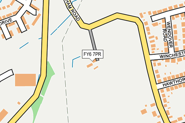
FY6 7PR is located in the Carleton electoral ward, within the local authority district of Wyre and the English Parliamentary constituency of Wyre and Preston North. The Sub Integrated Care Board (ICB) Location is NHS Lancashire and South Cumbria ICB - 02M and the police force is Lancashire. This postcode has been in use since January 1980.


GetTheData
Source: OS OpenMap – Local (Ordnance Survey)
Source: OS VectorMap District (Ordnance Survey)
Licence: Open Government Licence (requires attribution)
| Easting | 333212 |
| Northing | 440425 |
| Latitude | 53.855737 |
| Longitude | -3.016856 |
GetTheData
Source: Open Postcode Geo
Licence: Open Government Licence
| Country | England |
| Postcode District | FY6 |
| ➜ FY6 open data dashboard ➜ See where FY6 is on a map | |
GetTheData
Source: Land Registry Price Paid Data
Licence: Open Government Licence
Elevation or altitude of FY6 7PR as distance above sea level:
| Metres | Feet | |
|---|---|---|
| Elevation | 10m | 33ft |
Elevation is measured from the approximate centre of the postcode, to the nearest point on an OS contour line from OS Terrain 50, which has contour spacing of ten vertical metres.
➜ How high above sea level am I? Find the elevation of your current position using your device's GPS.
GetTheData
Source: Open Postcode Elevation
Licence: Open Government Licence
| Ward | Carleton |
| Constituency | Wyre And Preston North |
GetTheData
Source: ONS Postcode Database
Licence: Open Government Licence
| June 2022 | Violence and sexual offences | On or near Winchester Drive | 274m |
| June 2022 | Other theft | On or near Hawthorne Grove | 305m |
| June 2022 | Violence and sexual offences | On or near Beaumont Gardens | 414m |
| ➜ Get more crime data in our Crime section | |||
GetTheData
Source: data.police.uk
Licence: Open Government Licence
| Winchester Drive | Carleton | 193m |
| Faraday Way | Kincraig Estate | 246m |
| Wendover Rd (Winchester Drive) | Carleton | 265m |
| Wendover Rd (Winchester Drive) | Carleton | 274m |
| Faraday Way | Kincraig Estate | 324m |
| Poulton-le-Fylde Station | 1.9km |
| Layton (Lancs) Station | 2.4km |
| Blackpool North Station | 4.3km |
GetTheData
Source: NaPTAN
Licence: Open Government Licence
| Percentage of properties with Next Generation Access | 100.0% |
| Percentage of properties with Superfast Broadband | 100.0% |
| Percentage of properties with Ultrafast Broadband | 0.0% |
| Percentage of properties with Full Fibre Broadband | 0.0% |
Superfast Broadband is between 30Mbps and 300Mbps
Ultrafast Broadband is > 300Mbps
| Percentage of properties unable to receive 2Mbps | 0.0% |
| Percentage of properties unable to receive 5Mbps | 0.0% |
| Percentage of properties unable to receive 10Mbps | 0.0% |
| Percentage of properties unable to receive 30Mbps | 0.0% |
GetTheData
Source: Ofcom
Licence: Ofcom Terms of Use (requires attribution)
GetTheData
Source: ONS Postcode Database
Licence: Open Government Licence


➜ Get more ratings from the Food Standards Agency
GetTheData
Source: Food Standards Agency
Licence: FSA terms & conditions
| Last Collection | |||
|---|---|---|---|
| Location | Mon-Fri | Sat | Distance |
| Hawthorne Grove, Carleton | 16:45 | 12:00 | 231m |
| 131 Kincraig Place | 17:15 | 13:15 | 618m |
| Arundale Drive | 17:00 | 12:00 | 629m |
GetTheData
Source: Dracos
Licence: Creative Commons Attribution-ShareAlike
| Facility | Distance |
|---|---|
| Kincraig Primary School Kincraig Road, Blackpool Grass Pitches | 496m |
| Carleton St Hilda's C Of E Primary School Bispham Road, Poulton-le-fylde Grass Pitches | 639m |
| Blackpool And The Fylde College (Bispham Campus) Ashfield Road, Blackpool Sports Hall, Artificial Grass Pitch, Health and Fitness Gym | 742m |
GetTheData
Source: Active Places
Licence: Open Government Licence
| School | Phase of Education | Distance |
|---|---|---|
| Kincraig Primary School Kincraig Road, Bispham, Blackpool, FY2 0HN | Primary | 495m |
| Carleton St Hilda's Church of England Primary School Bispham Road, Carleton, Poulton-le-Fylde, FY6 7PE | Primary | 640m |
| Blackpool and the Fylde College Ashfield Road, Bispham, Blackpool, FY2 0HB | 16 plus | 742m |
GetTheData
Source: Edubase
Licence: Open Government Licence
The below table lists the International Territorial Level (ITL) codes (formerly Nomenclature of Territorial Units for Statistics (NUTS) codes) and Local Administrative Units (LAU) codes for FY6 7PR:
| ITL 1 Code | Name |
|---|---|
| TLD | North West (England) |
| ITL 2 Code | Name |
| TLD4 | Lancashire |
| ITL 3 Code | Name |
| TLD44 | Lancaster and Wyre |
| LAU 1 Code | Name |
| E07000128 | Wyre |
GetTheData
Source: ONS Postcode Directory
Licence: Open Government Licence
The below table lists the Census Output Area (OA), Lower Layer Super Output Area (LSOA), and Middle Layer Super Output Area (MSOA) for FY6 7PR:
| Code | Name | |
|---|---|---|
| OA | E00129661 | |
| LSOA | E01025550 | Wyre 012A |
| MSOA | E02005330 | Wyre 012 |
GetTheData
Source: ONS Postcode Directory
Licence: Open Government Licence
| FY6 7PL | Bispham Road | 204m |
| FY2 0FX | Housman Close | 231m |
| FY2 0FQ | Betjeman Close | 252m |
| FY6 7PT | Wendover Road | 252m |
| FY6 7PJ | Bispham Road | 294m |
| FY2 0GH | Tennyson Drive | 295m |
| FY2 0GU | Shelly Close | 302m |
| FY6 7PN | Hawthorne Grove | 309m |
| FY6 7PS | Winchester Drive | 310m |
| FY2 0GF | Keats Close | 326m |
GetTheData
Source: Open Postcode Geo; Land Registry Price Paid Data
Licence: Open Government Licence