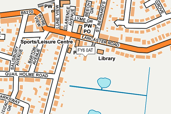
FY6 0AT lies on Plantation Avenue in Knott End On Sea, Poulton-le-fylde. FY6 0AT is located in the Preesall electoral ward, within the local authority district of Wyre and the English Parliamentary constituency of Lancaster and Fleetwood. The Sub Integrated Care Board (ICB) Location is NHS Lancashire and South Cumbria ICB - 02M and the police force is Lancashire. This postcode has been in use since January 1980.


GetTheData
Source: OS OpenMap – Local (Ordnance Survey)
Source: OS VectorMap District (Ordnance Survey)
Licence: Open Government Licence (requires attribution)
| Easting | 335328 |
| Northing | 448359 |
| Latitude | 53.927304 |
| Longitude | -2.986370 |
GetTheData
Source: Open Postcode Geo
Licence: Open Government Licence
| Street | Plantation Avenue |
| Locality | Knott End On Sea |
| Town/City | Poulton-le-fylde |
| Country | England |
| Postcode District | FY6 |
➜ See where FY6 is on a map ➜ Where is Knott End-on-Sea? | |
GetTheData
Source: Land Registry Price Paid Data
Licence: Open Government Licence
Elevation or altitude of FY6 0AT as distance above sea level:
| Metres | Feet | |
|---|---|---|
| Elevation | 10m | 33ft |
Elevation is measured from the approximate centre of the postcode, to the nearest point on an OS contour line from OS Terrain 50, which has contour spacing of ten vertical metres.
➜ How high above sea level am I? Find the elevation of your current position using your device's GPS.
GetTheData
Source: Open Postcode Elevation
Licence: Open Government Licence
| Ward | Preesall |
| Constituency | Lancaster And Fleetwood |
GetTheData
Source: ONS Postcode Database
Licence: Open Government Licence
| Library (Lancaster Road) | Knott End On Sea | 73m |
| Library (Lancaster Road) | Knott End On Sea | 132m |
| Barton Square (Lancaster Road) | Knott End On Sea | 149m |
| Barton Square (Lancaster Road) | Knott End On Sea | 149m |
| Esplanade | Knott End On Sea | 400m |
| Fleetwood Ferry (Blackpool Tramway) (Queens Terrace) | Fleetwood | 1,422m |
| Victoria Street (Blackpool Tramway) (Victoria Street) | Fleetwood | 1,486m |
GetTheData
Source: NaPTAN
Licence: Open Government Licence
| Percentage of properties with Next Generation Access | 100.0% |
| Percentage of properties with Superfast Broadband | 100.0% |
| Percentage of properties with Ultrafast Broadband | 0.0% |
| Percentage of properties with Full Fibre Broadband | 0.0% |
Superfast Broadband is between 30Mbps and 300Mbps
Ultrafast Broadband is > 300Mbps
| Percentage of properties unable to receive 2Mbps | 0.0% |
| Percentage of properties unable to receive 5Mbps | 0.0% |
| Percentage of properties unable to receive 10Mbps | 0.0% |
| Percentage of properties unable to receive 30Mbps | 0.0% |
GetTheData
Source: Ofcom
Licence: Ofcom Terms of Use (requires attribution)
GetTheData
Source: ONS Postcode Database
Licence: Open Government Licence


➜ Get more ratings from the Food Standards Agency
GetTheData
Source: Food Standards Agency
Licence: FSA terms & conditions
| Last Collection | |||
|---|---|---|---|
| Location | Mon-Fri | Sat | Distance |
| Knott End Post Office | 16:45 | 11:15 | 84m |
| 29 Parksway, Knott End | 16:45 | 11:15 | 435m |
| Rosemount Crescent | 16:15 | 11:00 | 732m |
GetTheData
Source: Dracos
Licence: Creative Commons Attribution-ShareAlike
| Risk of FY6 0AT flooding from rivers and sea | Very Low |
| ➜ FY6 0AT flood map | |
GetTheData
Source: Open Flood Risk by Postcode
Licence: Open Government Licence
The below table lists the International Territorial Level (ITL) codes (formerly Nomenclature of Territorial Units for Statistics (NUTS) codes) and Local Administrative Units (LAU) codes for FY6 0AT:
| ITL 1 Code | Name |
|---|---|
| TLD | North West (England) |
| ITL 2 Code | Name |
| TLD4 | Lancashire |
| ITL 3 Code | Name |
| TLD44 | Lancaster and Wyre |
| LAU 1 Code | Name |
| E07000128 | Wyre |
GetTheData
Source: ONS Postcode Directory
Licence: Open Government Licence
The below table lists the Census Output Area (OA), Lower Layer Super Output Area (LSOA), and Middle Layer Super Output Area (MSOA) for FY6 0AT:
| Code | Name | |
|---|---|---|
| OA | E00129848 | |
| LSOA | E01025588 | Wyre 004F |
| MSOA | E02005322 | Wyre 004 |
GetTheData
Source: ONS Postcode Directory
Licence: Open Government Licence
| FY6 0AX | Hackensall Road | 77m |
| FY6 0AU | Lancaster Road | 77m |
| FY6 0AS | Lancaster Road | 104m |
| FY6 0AR | Lancaster Road | 107m |
| FY6 0AQ | Lancaster Road | 130m |
| FY6 0AJ | Lyme Grove | 140m |
| FY6 0BW | Barton Avenue | 156m |
| FY6 0AF | Elterwater | 161m |
| FY6 0AH | Clarence Avenue | 163m |
| FY6 0AG | Lune View | 167m |
GetTheData
Source: Open Postcode Geo; Land Registry Price Paid Data
Licence: Open Government Licence