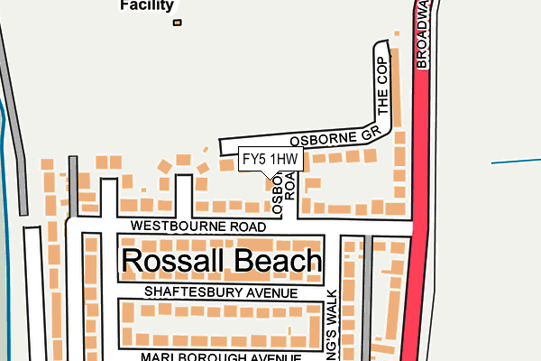
FY5 1HW lies on Osborne Road in Thornton-cleveleys. FY5 1HW is located in the Jubilee electoral ward, within the local authority district of Wyre and the English Parliamentary constituency of Blackpool North and Cleveleys. The Sub Integrated Care Board (ICB) Location is NHS Lancashire and South Cumbria ICB - 02M and the police force is Lancashire. This postcode has been in use since January 1980.


GetTheData
Source: OS OpenMap – Local (Ordnance Survey)
Source: OS VectorMap District (Ordnance Survey)
Licence: Open Government Licence (requires attribution)
| Easting | 331571 |
| Northing | 444428 |
| Latitude | 53.891495 |
| Longitude | -3.042694 |
GetTheData
Source: Open Postcode Geo
Licence: Open Government Licence
| Street | Osborne Road |
| Town/City | Thornton-cleveleys |
| Country | England |
| Postcode District | FY5 |
➜ See where FY5 is on a map ➜ Where is Cleveleys? | |
GetTheData
Source: Land Registry Price Paid Data
Licence: Open Government Licence
Elevation or altitude of FY5 1HW as distance above sea level:
| Metres | Feet | |
|---|---|---|
| Elevation | 10m | 33ft |
Elevation is measured from the approximate centre of the postcode, to the nearest point on an OS contour line from OS Terrain 50, which has contour spacing of ten vertical metres.
➜ How high above sea level am I? Find the elevation of your current position using your device's GPS.
GetTheData
Source: Open Postcode Elevation
Licence: Open Government Licence
| Ward | Jubilee |
| Constituency | Blackpool North And Cleveleys |
GetTheData
Source: ONS Postcode Database
Licence: Open Government Licence
2, OSBORNE ROAD, THORNTON-CLEVELEYS, FY5 1HW 2013 28 JAN £250,000 |
GetTheData
Source: HM Land Registry Price Paid Data
Licence: Contains HM Land Registry data © Crown copyright and database right 2025. This data is licensed under the Open Government Licence v3.0.
| Kings Walk (Westbourne Road) | Cleveleys | 104m |
| Kings Walk (Westbourne Road) | Cleveleys | 112m |
| Westbourne Road (Broadway) | Rossall Beach | 163m |
| Westbourne Road (Broadway) | Rossall Beach | 171m |
| Green Drive | Cleveleys | 201m |
| Rossall Beach (Blackpool Tramway) (Rossall Road) | Rossall Beach | 462m |
| Rossall School (Blackpool Tramway) (A587 Broadway) | Rossall Beach | 629m |
| Thornton Gate (Blackpool Tramway) (Thornton Gate) | Cleveleys | 927m |
| Rossall Square (Blackpool Tramway) (A587 Broadway) | Rossall Beach | 1,087m |
| West Drive (Blackpool Tramway) (West Drive) | Cleveleys | 1,264m |
| Poulton-le-Fylde Station | 5.9km |
GetTheData
Source: NaPTAN
Licence: Open Government Licence
| Percentage of properties with Next Generation Access | 100.0% |
| Percentage of properties with Superfast Broadband | 100.0% |
| Percentage of properties with Ultrafast Broadband | 0.0% |
| Percentage of properties with Full Fibre Broadband | 0.0% |
Superfast Broadband is between 30Mbps and 300Mbps
Ultrafast Broadband is > 300Mbps
| Percentage of properties unable to receive 2Mbps | 0.0% |
| Percentage of properties unable to receive 5Mbps | 0.0% |
| Percentage of properties unable to receive 10Mbps | 0.0% |
| Percentage of properties unable to receive 30Mbps | 0.0% |
GetTheData
Source: Ofcom
Licence: Ofcom Terms of Use (requires attribution)
GetTheData
Source: ONS Postcode Database
Licence: Open Government Licence


➜ Get more ratings from the Food Standards Agency
GetTheData
Source: Food Standards Agency
Licence: FSA terms & conditions
| Last Collection | |||
|---|---|---|---|
| Location | Mon-Fri | Sat | Distance |
| Rossall Beach | 17:15 | 12:00 | 357m |
| 50 Green Drive, Cleveleys | 17:00 | 12:00 | 368m |
| Thornton Gate | 17:00 | 12:00 | 654m |
GetTheData
Source: Dracos
Licence: Creative Commons Attribution-ShareAlike
| Risk of FY5 1HW flooding from rivers and sea | Low |
| ➜ FY5 1HW flood map | |
GetTheData
Source: Open Flood Risk by Postcode
Licence: Open Government Licence
The below table lists the International Territorial Level (ITL) codes (formerly Nomenclature of Territorial Units for Statistics (NUTS) codes) and Local Administrative Units (LAU) codes for FY5 1HW:
| ITL 1 Code | Name |
|---|---|
| TLD | North West (England) |
| ITL 2 Code | Name |
| TLD4 | Lancashire |
| ITL 3 Code | Name |
| TLD44 | Lancaster and Wyre |
| LAU 1 Code | Name |
| E07000128 | Wyre |
GetTheData
Source: ONS Postcode Directory
Licence: Open Government Licence
The below table lists the Census Output Area (OA), Lower Layer Super Output Area (LSOA), and Middle Layer Super Output Area (MSOA) for FY5 1HW:
| Code | Name | |
|---|---|---|
| OA | E00129768 | |
| LSOA | E01025572 | Wyre 008E |
| MSOA | E02005326 | Wyre 008 |
GetTheData
Source: ONS Postcode Directory
Licence: Open Government Licence
| FY5 1HR | Osborne Grove | 31m |
| FY5 1HN | Westbourne Road | 31m |
| FY5 1HL | Westbourne Road | 76m |
| FY5 1HP | Osborne Grove | 99m |
| FY5 1HS | College Gate | 104m |
| FY5 1HH | Broadway | 143m |
| FY5 1HU | Shaftesbury Avenue | 151m |
| FY5 1HT | Kings Walk | 178m |
| FY5 1HZ | Kings Walk | 197m |
| FY5 1JD | Green Drive | 207m |
GetTheData
Source: Open Postcode Geo; Land Registry Price Paid Data
Licence: Open Government Licence