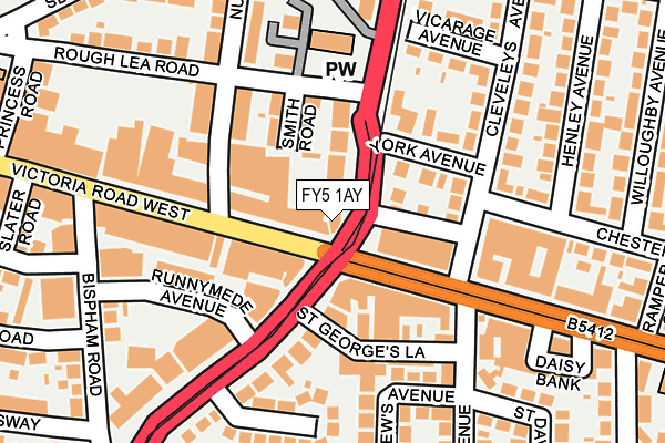
FY5 1AY is located in the Jubilee electoral ward, within the local authority district of Wyre and the English Parliamentary constituency of Blackpool North and Cleveleys. The Sub Integrated Care Board (ICB) Location is NHS Lancashire and South Cumbria ICB - 02M and the police force is Lancashire. This postcode has been in use since January 1991.


GetTheData
Source: OS OpenMap – Local (Ordnance Survey)
Source: OS VectorMap District (Ordnance Survey)
Licence: Open Government Licence (requires attribution)
| Easting | 331705 |
| Northing | 442834 |
| Latitude | 53.877202 |
| Longitude | -3.040293 |
GetTheData
Source: Open Postcode Geo
Licence: Open Government Licence
| Country | England |
| Postcode District | FY5 |
➜ See where FY5 is on a map ➜ Where is Cleveleys? | |
GetTheData
Source: Land Registry Price Paid Data
Licence: Open Government Licence
Elevation or altitude of FY5 1AY as distance above sea level:
| Metres | Feet | |
|---|---|---|
| Elevation | 10m | 33ft |
Elevation is measured from the approximate centre of the postcode, to the nearest point on an OS contour line from OS Terrain 50, which has contour spacing of ten vertical metres.
➜ How high above sea level am I? Find the elevation of your current position using your device's GPS.
GetTheData
Source: Open Postcode Elevation
Licence: Open Government Licence
| Ward | Jubilee |
| Constituency | Blackpool North And Cleveleys |
GetTheData
Source: ONS Postcode Database
Licence: Open Government Licence
| Victoria Square (Rossall Road) | Cleveleys | 46m |
| Victoria Square (Victoria Road West) | Cleveleys | 66m |
| Victoria Square (Victoria Road West) | Cleveleys | 74m |
| Victoria Square (Cleveleys Crescent) | Cleveleys | 92m |
| Nutter Road (Victoria Road West) | Cleveleys | 92m |
| Cleveleys (Blackpool Tramway) (York Avenue) | Cleveleys | 58m |
| West Drive (Blackpool Tramway) (West Drive) | Cleveleys | 361m |
| Anchorsholme (Blackpool Tramway) (Kelso Avenue) | Anchorsholme | 666m |
| Thornton Gate (Blackpool Tramway) (Thornton Gate) | Cleveleys | 690m |
| Rossall Beach (Blackpool Tramway) (Rossall Road) | Rossall Beach | 1,156m |
| Poulton-le-Fylde Station | 4.6km |
| Layton (Lancs) Station | 4.7km |
GetTheData
Source: NaPTAN
Licence: Open Government Licence
GetTheData
Source: ONS Postcode Database
Licence: Open Government Licence


➜ Get more ratings from the Food Standards Agency
GetTheData
Source: Food Standards Agency
Licence: FSA terms & conditions
| Last Collection | |||
|---|---|---|---|
| Location | Mon-Fri | Sat | Distance |
| Cleveleys Post Office | 17:30 | 11:30 | 71m |
| Cleveleys Post Office | 18:15 | 12:15 | 72m |
| Bispham Road | 16:00 | 11:30 | 223m |
GetTheData
Source: Dracos
Licence: Creative Commons Attribution-ShareAlike
| Risk of FY5 1AY flooding from rivers and sea | Very Low |
| ➜ FY5 1AY flood map | |
GetTheData
Source: Open Flood Risk by Postcode
Licence: Open Government Licence
The below table lists the International Territorial Level (ITL) codes (formerly Nomenclature of Territorial Units for Statistics (NUTS) codes) and Local Administrative Units (LAU) codes for FY5 1AY:
| ITL 1 Code | Name |
|---|---|
| TLD | North West (England) |
| ITL 2 Code | Name |
| TLD4 | Lancashire |
| ITL 3 Code | Name |
| TLD44 | Lancaster and Wyre |
| LAU 1 Code | Name |
| E07000128 | Wyre |
GetTheData
Source: ONS Postcode Directory
Licence: Open Government Licence
The below table lists the Census Output Area (OA), Lower Layer Super Output Area (LSOA), and Middle Layer Super Output Area (MSOA) for FY5 1AY:
| Code | Name | |
|---|---|---|
| OA | E00129765 | |
| LSOA | E01025570 | Wyre 008C |
| MSOA | E02005326 | Wyre 008 |
GetTheData
Source: ONS Postcode Directory
Licence: Open Government Licence
| FY5 3LU | Crescent East | 53m |
| FY5 2AA | Brighton Avenue | 67m |
| FY5 1AP | Rossall Road | 70m |
| FY5 1AJ | Victoria Road West | 91m |
| FY5 1BH | Smith Road | 95m |
| FY5 3LJ | Crescent East | 97m |
| FY5 3LG | Victoria Road West | 99m |
| FY5 2UH | Cleveleys Avenue | 108m |
| FY5 3LT | St Georges Lane | 116m |
| FY5 2UG | York Avenue | 118m |
GetTheData
Source: Open Postcode Geo; Land Registry Price Paid Data
Licence: Open Government Licence