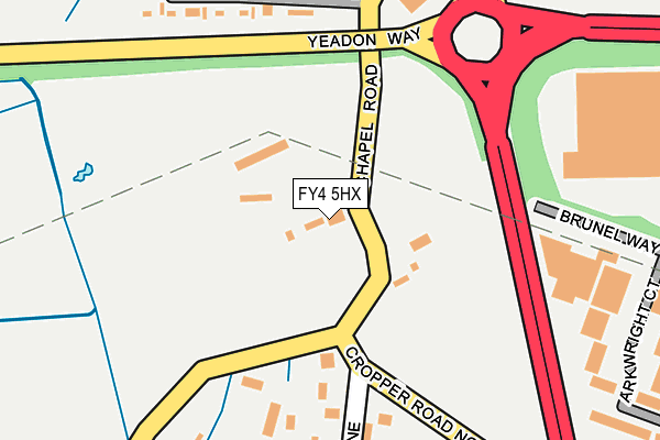
FY4 5HX lies on Chapel Road in Blackpool. FY4 5HX is located in the Stanley electoral ward, within the unitary authority of Blackpool and the English Parliamentary constituency of Blackpool South. The Sub Integrated Care Board (ICB) Location is NHS Lancashire and South Cumbria ICB - 00R and the police force is Lancashire. This postcode has been in use since January 1980.


GetTheData
Source: OS OpenMap – Local (Ordnance Survey)
Source: OS VectorMap District (Ordnance Survey)
Licence: Open Government Licence (requires attribution)
| Easting | 333999 |
| Northing | 433332 |
| Latitude | 53.792111 |
| Longitude | -3.003365 |
GetTheData
Source: Open Postcode Geo
Licence: Open Government Licence
| Street | Chapel Road |
| Town/City | Blackpool |
| Country | England |
| Postcode District | FY4 |
| ➜ FY4 open data dashboard ➜ See where FY4 is on a map ➜ Where is Blackpool? | |
GetTheData
Source: Land Registry Price Paid Data
Licence: Open Government Licence
Elevation or altitude of FY4 5HX as distance above sea level:
| Metres | Feet | |
|---|---|---|
| Elevation | 10m | 33ft |
Elevation is measured from the approximate centre of the postcode, to the nearest point on an OS contour line from OS Terrain 50, which has contour spacing of ten vertical metres.
➜ How high above sea level am I? Find the elevation of your current position using your device's GPS.
GetTheData
Source: Open Postcode Elevation
Licence: Open Government Licence
| Ward | Stanley |
| Constituency | Blackpool South |
GetTheData
Source: ONS Postcode Database
Licence: Open Government Licence
| June 2022 | Criminal damage and arson | On or near Dickie'S Lane | 223m |
| June 2022 | Drugs | On or near Jenny Lane | 321m |
| June 2022 | Drugs | On or near Jenny Lane | 321m |
| ➜ Chapel Road crime map and outcomes | |||
GetTheData
Source: data.police.uk
Licence: Open Government Licence
| Dwp Peel Park (Brunel Way) | Peel Park | 414m |
| Deepdale Road (Clifton Road) | Mereside | 574m |
| Deepdale Road (Clifton Road) | Mereside | 584m |
| Cornford Road (Clifton Road) | Mereside | 696m |
| Progress House (Clifton Road) | Mereside | 714m |
| Blackpool South Station | 3.1km |
| Blackpool Pleasure Beach Station | 3.4km |
| Squires Gate Station | 3.5km |
GetTheData
Source: NaPTAN
Licence: Open Government Licence
| Percentage of properties with Next Generation Access | 100.0% |
| Percentage of properties with Superfast Broadband | 0.0% |
| Percentage of properties with Ultrafast Broadband | 0.0% |
| Percentage of properties with Full Fibre Broadband | 0.0% |
Superfast Broadband is between 30Mbps and 300Mbps
Ultrafast Broadband is > 300Mbps
| Percentage of properties unable to receive 2Mbps | 0.0% |
| Percentage of properties unable to receive 5Mbps | 0.0% |
| Percentage of properties unable to receive 10Mbps | 0.0% |
| Percentage of properties unable to receive 30Mbps | 100.0% |
GetTheData
Source: Ofcom
Licence: Ofcom Terms of Use (requires attribution)
GetTheData
Source: ONS Postcode Database
Licence: Open Government Licence


➜ Get more ratings from the Food Standards Agency
GetTheData
Source: Food Standards Agency
Licence: FSA terms & conditions
| Last Collection | |||
|---|---|---|---|
| Location | Mon-Fri | Sat | Distance |
| Fylde Industrial Estate | 17:30 | 12:00 | 252m |
| Clifton Road | 17:30 | 12:00 | 664m |
| Clifton Road | 18:15 | 666m | |
GetTheData
Source: Dracos
Licence: Creative Commons Attribution-ShareAlike
| Facility | Distance |
|---|---|
| Universe Gym (Closed) Binwell Road, Blackpool Health and Fitness Gym, Studio | 773m |
| Mereside Bowness Avenue, Blackpool Grass Pitches, Cycling | 826m |
| St Georges Swimming Pool (Closed) Cherry Tree Road, Blackpool Swimming Pool | 993m |
GetTheData
Source: Active Places
Licence: Open Government Licence
| School | Phase of Education | Distance |
|---|---|---|
| Lotus School Langdale Road, Blackpool, FY4 4RR | Not applicable | 874m |
| Mereside Primary Academy Langdale Road, Blackpool, FY4 4RR | Primary | 933m |
| St George's School A Church of England Academy Cherry Tree Road, Marton, Blackpool, FY4 4PH | Secondary | 993m |
GetTheData
Source: Edubase
Licence: Open Government Licence
The below table lists the International Territorial Level (ITL) codes (formerly Nomenclature of Territorial Units for Statistics (NUTS) codes) and Local Administrative Units (LAU) codes for FY4 5HX:
| ITL 1 Code | Name |
|---|---|
| TLD | North West (England) |
| ITL 2 Code | Name |
| TLD4 | Lancashire |
| ITL 3 Code | Name |
| TLD42 | Blackpool |
| LAU 1 Code | Name |
| E06000009 | Blackpool |
GetTheData
Source: ONS Postcode Directory
Licence: Open Government Licence
The below table lists the Census Output Area (OA), Lower Layer Super Output Area (LSOA), and Middle Layer Super Output Area (MSOA) for FY4 5HX:
| Code | Name | |
|---|---|---|
| OA | E00064208 | |
| LSOA | E01012732 | Blackpool 018E |
| MSOA | E02002650 | Blackpool 018 |
GetTheData
Source: ONS Postcode Directory
Licence: Open Government Licence
| FY4 5QQ | Bambers Lane North | 240m |
| FY4 5LG | Dickies Lane | 314m |
| FY4 5HU | Chapel Road | 382m |
| FY4 4QS | Lee Road | 530m |
| FY4 5JJ | Orchid Square | 551m |
| FY4 4PW | Whalley Lane | 552m |
| FY4 4QN | Mitcham Road | 554m |
| FY4 4AL | Lindbeck Road | 600m |
| FY4 5HR | Stockydale Road | 631m |
| FY4 4QQ | Cornford Road | 631m |
GetTheData
Source: Open Postcode Geo; Land Registry Price Paid Data
Licence: Open Government Licence