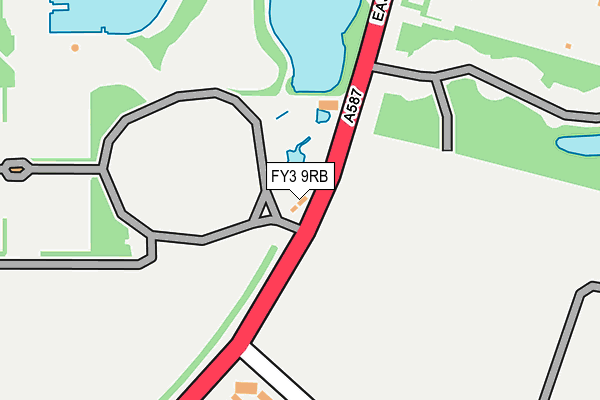
FY3 9RB is located in the Marton electoral ward, within the unitary authority of Blackpool and the English Parliamentary constituency of Blackpool South. The Sub Integrated Care Board (ICB) Location is NHS Lancashire and South Cumbria ICB - 00R and the police force is Lancashire. This postcode has been in use since April 1985.


GetTheData
Source: OS OpenMap – Local (Ordnance Survey)
Source: OS VectorMap District (Ordnance Survey)
Licence: Open Government Licence (requires attribution)
| Easting | 332995 |
| Northing | 435597 |
| Latitude | 53.812322 |
| Longitude | -3.019100 |
GetTheData
Source: Open Postcode Geo
Licence: Open Government Licence
| Country | England |
| Postcode District | FY3 |
| ➜ FY3 open data dashboard ➜ See where FY3 is on a map ➜ Where is Blackpool? | |
GetTheData
Source: Land Registry Price Paid Data
Licence: Open Government Licence
Elevation or altitude of FY3 9RB as distance above sea level:
| Metres | Feet | |
|---|---|---|
| Elevation | 10m | 33ft |
Elevation is measured from the approximate centre of the postcode, to the nearest point on an OS contour line from OS Terrain 50, which has contour spacing of ten vertical metres.
➜ How high above sea level am I? Find the elevation of your current position using your device's GPS.
GetTheData
Source: Open Postcode Elevation
Licence: Open Government Licence
| Ward | Marton |
| Constituency | Blackpool South |
GetTheData
Source: ONS Postcode Database
Licence: Open Government Licence
| October 2023 | Public order | On or near Park/Open Space | 418m |
| September 2023 | Anti-social behaviour | On or near Park/Open Space | 418m |
| September 2023 | Criminal damage and arson | On or near Park/Open Space | 418m |
| ➜ Get more crime data in our Crime section | |||
GetTheData
Source: data.police.uk
Licence: Open Government Licence
| Model Village (East Park Drive) | Blackpool Zoo | 25m |
| Model Village (East Park Drive) | Blackpool Zoo | 93m |
| Weymouth Road (South Park Drive) | Marton | 426m |
| Zoo (South West Gate) (East Park Drive) | Stanley Park | 437m |
| Weymouth Road (South Park Drive) | Marton | 456m |
| Blackpool North Station | 2.3km |
| Blackpool South Station | 2.5km |
| Layton (Lancs) Station | 2.7km |
GetTheData
Source: NaPTAN
Licence: Open Government Licence
GetTheData
Source: ONS Postcode Database
Licence: Open Government Licence


➜ Get more ratings from the Food Standards Agency
GetTheData
Source: Food Standards Agency
Licence: FSA terms & conditions
| Last Collection | |||
|---|---|---|---|
| Location | Mon-Fri | Sat | Distance |
| 63 St Leonards Road | 16:30 | 11:30 | 454m |
| Knowsley Avenue | 16:30 | 12:30 | 624m |
| Canterbury Avenue | 16:30 | 11:30 | 756m |
GetTheData
Source: Dracos
Licence: Creative Commons Attribution-ShareAlike
| Facility | Distance |
|---|---|
| Stanley Park (Blackpool) West Park Drive, Blackpool Grass Pitches, Outdoor Tennis Courts, Cycling | 338m |
| Stanley Park All Weather Pitches West Park Drive, Blackpool Artificial Grass Pitch | 442m |
| Village Gym (Blackpool) East Park Drive, Blackpool Swimming Pool, Health and Fitness Gym, Golf, Studio, Squash Courts, Outdoor Tennis Courts | 555m |
GetTheData
Source: Active Places
Licence: Open Government Licence
| School | Phase of Education | Distance |
|---|---|---|
| Park Community Academy 158 Whitegate Drive, Blackpool, FY3 9HF | Not applicable | 834m |
| Woodlands School Whitegate Drive, Blackpool, FY3 9HF | Not applicable | 845m |
| Educational Diversity 278a Whitegate Drive, Blackpool, FY3 9JW | Not applicable | 913m |
GetTheData
Source: Edubase
Licence: Open Government Licence
The below table lists the International Territorial Level (ITL) codes (formerly Nomenclature of Territorial Units for Statistics (NUTS) codes) and Local Administrative Units (LAU) codes for FY3 9RB:
| ITL 1 Code | Name |
|---|---|
| TLD | North West (England) |
| ITL 2 Code | Name |
| TLD4 | Lancashire |
| ITL 3 Code | Name |
| TLD42 | Blackpool |
| LAU 1 Code | Name |
| E06000009 | Blackpool |
GetTheData
Source: ONS Postcode Directory
Licence: Open Government Licence
The below table lists the Census Output Area (OA), Lower Layer Super Output Area (LSOA), and Middle Layer Super Output Area (MSOA) for FY3 9RB:
| Code | Name | |
|---|---|---|
| OA | E00064104 | |
| LSOA | E01012712 | Blackpool 012A |
| MSOA | E02002644 | Blackpool 012 |
GetTheData
Source: ONS Postcode Directory
Licence: Open Government Licence
| FY3 9RS | East Park Drive | 267m |
| FY3 9RT | Lawson Road | 269m |
| FY3 9RL | Colchester Road | 289m |
| FY3 9RX | Abbotsford Road | 336m |
| FY3 9RU | St Leonards Road | 363m |
| FY3 9RQ | Worcester Road | 368m |
| FY3 9RN | Weymouth Road | 411m |
| FY3 9RE | St Leonards Road | 416m |
| FY3 9RJ | Goldsboro Avenue | 429m |
| FY3 9TD | Lawson Road | 438m |
GetTheData
Source: Open Postcode Geo; Land Registry Price Paid Data
Licence: Open Government Licence