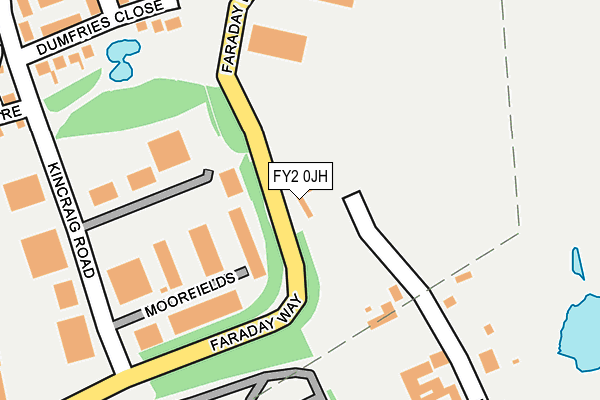
FY2 0JH is located in the Ingthorpe electoral ward, within the unitary authority of Blackpool and the English Parliamentary constituency of Blackpool North and Cleveleys. The Sub Integrated Care Board (ICB) Location is NHS Lancashire and South Cumbria ICB - 00R and the police force is Lancashire. This postcode has been in use since October 2003.


GetTheData
Source: OS OpenMap – Local (Ordnance Survey)
Source: OS VectorMap District (Ordnance Survey)
Licence: Open Government Licence (requires attribution)
| Easting | 332979 |
| Northing | 440138 |
| Latitude | 53.853142 |
| Longitude | -3.020329 |
GetTheData
Source: Open Postcode Geo
Licence: Open Government Licence
| Country | England |
| Postcode District | FY2 |
| ➜ FY2 open data dashboard ➜ See where FY2 is on a map ➜ Where is Blackpool? | |
GetTheData
Source: Land Registry Price Paid Data
Licence: Open Government Licence
Elevation or altitude of FY2 0JH as distance above sea level:
| Metres | Feet | |
|---|---|---|
| Elevation | 10m | 33ft |
Elevation is measured from the approximate centre of the postcode, to the nearest point on an OS contour line from OS Terrain 50, which has contour spacing of ten vertical metres.
➜ How high above sea level am I? Find the elevation of your current position using your device's GPS.
GetTheData
Source: Open Postcode Elevation
Licence: Open Government Licence
| Ward | Ingthorpe |
| Constituency | Blackpool North And Cleveleys |
GetTheData
Source: ONS Postcode Database
Licence: Open Government Licence
| June 2022 | Anti-social behaviour | On or near Further/Higher Educational Building | 83m |
| June 2022 | Anti-social behaviour | On or near Kilmory Place | 241m |
| June 2022 | Anti-social behaviour | On or near Kilmory Place | 241m |
| ➜ Get more crime data in our Crime section | |||
GetTheData
Source: data.police.uk
Licence: Open Government Licence
| Faraday Way | Kincraig Estate | 98m |
| Faraday Way | Kincraig Estate | 102m |
| Faraday Way | Kincraig Estate | 187m |
| Faraday Way (Farday Way) | Kincraig Estate | 232m |
| Dumfries Close (Kincraig Road) | Kincraig Estate | 323m |
| Poulton-le-Fylde Station | 2km |
| Layton (Lancs) Station | 2.1km |
| Blackpool North Station | 4km |
GetTheData
Source: NaPTAN
Licence: Open Government Licence
GetTheData
Source: ONS Postcode Database
Licence: Open Government Licence


➜ Get more ratings from the Food Standards Agency
GetTheData
Source: Food Standards Agency
Licence: FSA terms & conditions
| Last Collection | |||
|---|---|---|---|
| Location | Mon-Fri | Sat | Distance |
| Kincraig Road | 17:15 | 13:00 | 328m |
| Hawthorne Grove, Carleton | 16:45 | 12:00 | 486m |
| Tarragon Drive | 16:00 | 11:00 | 609m |
GetTheData
Source: Dracos
Licence: Creative Commons Attribution-ShareAlike
| Facility | Distance |
|---|---|
| Kincraig Primary School Kincraig Road, Blackpool Grass Pitches | 491m |
| Bispham Body Senze (Closed) Bristol Avenue, Blackpool Health and Fitness Gym, Studio | 664m |
| Blackpool And The Fylde College (Bispham Campus) Ashfield Road, Blackpool Sports Hall, Artificial Grass Pitch, Health and Fitness Gym | 799m |
GetTheData
Source: Active Places
Licence: Open Government Licence
| School | Phase of Education | Distance |
|---|---|---|
| Kincraig Primary School Kincraig Road, Bispham, Blackpool, FY2 0HN | Primary | 492m |
| Blackpool and the Fylde College Ashfield Road, Bispham, Blackpool, FY2 0HB | 16 plus | 799m |
| Carleton St Hilda's Church of England Primary School Bispham Road, Carleton, Poulton-le-Fylde, FY6 7PE | Primary | 824m |
GetTheData
Source: Edubase
Licence: Open Government Licence
The below table lists the International Territorial Level (ITL) codes (formerly Nomenclature of Territorial Units for Statistics (NUTS) codes) and Local Administrative Units (LAU) codes for FY2 0JH:
| ITL 1 Code | Name |
|---|---|
| TLD | North West (England) |
| ITL 2 Code | Name |
| TLD4 | Lancashire |
| ITL 3 Code | Name |
| TLD42 | Blackpool |
| LAU 1 Code | Name |
| E06000009 | Blackpool |
GetTheData
Source: ONS Postcode Directory
Licence: Open Government Licence
The below table lists the Census Output Area (OA), Lower Layer Super Output Area (LSOA), and Middle Layer Super Output Area (MSOA) for FY2 0JH:
| Code | Name | |
|---|---|---|
| OA | E00064069 | |
| LSOA | E01012704 | Blackpool 002C |
| MSOA | E02002634 | Blackpool 002 |
GetTheData
Source: ONS Postcode Directory
Licence: Open Government Licence
| FY2 0JW | Blackpool Technology Centre | 83m |
| FY2 0JN | Hawking Place | 178m |
| FY2 0XT | Kilmory Place | 231m |
| FY2 0XU | Dumfries Close | 268m |
| FY2 0XS | Kilmory Place | 280m |
| FY2 0PJ | Kincraig Road | 316m |
| FY2 0FY | Kincraig Court | 367m |
| FY2 0GU | Shelly Close | 374m |
| FY2 0YB | Strathyre Close | 379m |
| FY2 0BS | Glendale Close | 398m |
GetTheData
Source: Open Postcode Geo; Land Registry Price Paid Data
Licence: Open Government Licence