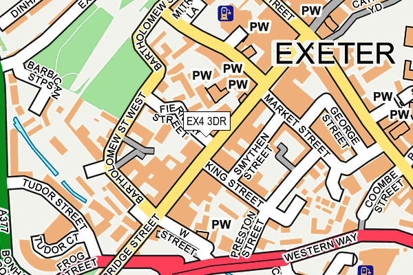
EX4 3DR lies on Fore Street Mews in Exeter. EX4 3DR is located in the St David's electoral ward, within the local authority district of Exeter and the English Parliamentary constituency of Exeter. The Sub Integrated Care Board (ICB) Location is NHS Devon ICB - 15N and the police force is Devon & Cornwall. This postcode has been in use since February 2003.


GetTheData
Source: OS OpenMap – Local (Ordnance Survey)
Source: OS VectorMap District (Ordnance Survey)
Licence: Open Government Licence (requires attribution)
| Easting | 291767 |
| Northing | 92409 |
| Latitude | 50.721195 |
| Longitude | -3.534634 |
GetTheData
Source: Open Postcode Geo
Licence: Open Government Licence
| Street | Fore Street Mews |
| Town/City | Exeter |
| Country | England |
| Postcode District | EX4 |
| ➜ EX4 open data dashboard ➜ See where EX4 is on a map ➜ Where is Exeter? | |
GetTheData
Source: Land Registry Price Paid Data
Licence: Open Government Licence
Elevation or altitude of EX4 3DR as distance above sea level:
| Metres | Feet | |
|---|---|---|
| Elevation | 30m | 98ft |
Elevation is measured from the approximate centre of the postcode, to the nearest point on an OS contour line from OS Terrain 50, which has contour spacing of ten vertical metres.
➜ How high above sea level am I? Find the elevation of your current position using your device's GPS.
GetTheData
Source: Open Postcode Elevation
Licence: Open Government Licence
| Ward | St David's |
| Constituency | Exeter |
GetTheData
Source: ONS Postcode Database
Licence: Open Government Licence
| October 2022 | Anti-social behaviour | On or near Bear Street | 281m |
| October 2022 | Criminal damage and arson | On or near Gater Lane | 316m |
| October 2022 | Violence and sexual offences | On or near Hayes Barton Court | 475m |
| ➜ Get more crime data in our Crime section | |||
GetTheData
Source: data.police.uk
Licence: Open Government Licence
| King Street | Exeter City Centre | 47m |
| King Street (Fore Street) | Exeter City Centre | 81m |
| Fore Street | Exeter City Centre | 142m |
| Fore Street | Exeter City Centre | 145m |
| Fore Street | Exeter City Centre | 155m |
| Exeter St Thomas Station | 0.5km |
| Exeter Central Station | 0.6km |
| Exeter St Davids Station | 1.1km |
GetTheData
Source: NaPTAN
Licence: Open Government Licence
| Percentage of properties with Next Generation Access | 100.0% |
| Percentage of properties with Superfast Broadband | 100.0% |
| Percentage of properties with Ultrafast Broadband | 100.0% |
| Percentage of properties with Full Fibre Broadband | 0.0% |
Superfast Broadband is between 30Mbps and 300Mbps
Ultrafast Broadband is > 300Mbps
| Percentage of properties unable to receive 2Mbps | 0.0% |
| Percentage of properties unable to receive 5Mbps | 0.0% |
| Percentage of properties unable to receive 10Mbps | 0.0% |
| Percentage of properties unable to receive 30Mbps | 0.0% |
GetTheData
Source: Ofcom
Licence: Ofcom Terms of Use (requires attribution)
GetTheData
Source: ONS Postcode Database
Licence: Open Government Licence


➜ Get more ratings from the Food Standards Agency
GetTheData
Source: Food Standards Agency
Licence: FSA terms & conditions
| Last Collection | |||
|---|---|---|---|
| Location | Mon-Fri | Sat | Distance |
| St Petrocks | 19:00 | 12:15 | 240m |
| St Petrocks | 19:00 | 12:15 | 240m |
| South Street | 19:00 | 12:15 | 243m |
GetTheData
Source: Dracos
Licence: Creative Commons Attribution-ShareAlike
| Facility | Distance |
|---|---|
| Puregym (Exeter Fore Street) Fore Street, Exeter Health and Fitness Gym | 168m |
| Fitness First (Exeter) (Closed) Tudor Street, Exeter Health and Fitness Gym, Studio | 258m |
| Studio One-to-one Fitness (Closed) Lower North Street, Exeter Health and Fitness Gym | 354m |
GetTheData
Source: Active Places
Licence: Open Government Licence
| School | Phase of Education | Distance |
|---|---|---|
| Exeter Cathedral School The Chantry, Palace Gate, Exeter, EX1 1HX | Not applicable | 302m |
| St David's CofE Primary School Dinham Road, Exeter, EX4 4EE | Primary | 400m |
| St Wilfrid's School 25-29 St David's Hill, Exeter, EX4 4DA | Not applicable | 541m |
GetTheData
Source: Edubase
Licence: Open Government Licence
The below table lists the International Territorial Level (ITL) codes (formerly Nomenclature of Territorial Units for Statistics (NUTS) codes) and Local Administrative Units (LAU) codes for EX4 3DR:
| ITL 1 Code | Name |
|---|---|
| TLK | South West (England) |
| ITL 2 Code | Name |
| TLK4 | Devon |
| ITL 3 Code | Name |
| TLK43 | Devon CC |
| LAU 1 Code | Name |
| E07000041 | Exeter |
GetTheData
Source: ONS Postcode Directory
Licence: Open Government Licence
The below table lists the Census Output Area (OA), Lower Layer Super Output Area (LSOA), and Middle Layer Super Output Area (MSOA) for EX4 3DR:
| Code | Name | |
|---|---|---|
| OA | E00101307 | |
| LSOA | E01020018 | Exeter 008E |
| MSOA | E02004156 | Exeter 008 |
GetTheData
Source: ONS Postcode Directory
Licence: Open Government Licence
| EX1 1BL | John Street | 25m |
| EX4 3AR | Friernhay Street | 29m |
| EX4 3JF | Fore Street | 40m |
| EX4 3AT | Fore Street | 45m |
| EX4 3AP | Priory Gardens | 47m |
| EX1 1BG | King Street | 50m |
| EX4 3AE | Bartholomew Street West | 58m |
| EX1 1AT | King Street | 59m |
| EX4 3HY | Fore Street | 69m |
| EX4 3BL | The Mint | 72m |
GetTheData
Source: Open Postcode Geo; Land Registry Price Paid Data
Licence: Open Government Licence