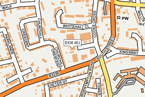
EX36 4EJ is located in the South Molton electoral ward, within the local authority district of North Devon and the English Parliamentary constituency of North Devon. The Sub Integrated Care Board (ICB) Location is NHS Devon ICB - 15N and the police force is Devon & Cornwall. This postcode has been in use since January 1980.


GetTheData
Source: OS OpenMap – Local (Ordnance Survey)
Source: OS VectorMap District (Ordnance Survey)
Licence: Open Government Licence (requires attribution)
| Easting | 271206 |
| Northing | 125394 |
| Latitude | 51.013462 |
| Longitude | -3.837385 |
GetTheData
Source: Open Postcode Geo
Licence: Open Government Licence
| Country | England |
| Postcode District | EX36 |
| ➜ EX36 open data dashboard ➜ See where EX36 is on a map ➜ Where is South Molton? | |
GetTheData
Source: Land Registry Price Paid Data
Licence: Open Government Licence
Elevation or altitude of EX36 4EJ as distance above sea level:
| Metres | Feet | |
|---|---|---|
| Elevation | 130m | 427ft |
Elevation is measured from the approximate centre of the postcode, to the nearest point on an OS contour line from OS Terrain 50, which has contour spacing of ten vertical metres.
➜ How high above sea level am I? Find the elevation of your current position using your device's GPS.
GetTheData
Source: Open Postcode Elevation
Licence: Open Government Licence
| Ward | South Molton |
| Constituency | North Devon |
GetTheData
Source: ONS Postcode Database
Licence: Open Government Licence
| July 2022 | Drugs | On or near King Street | 493m |
| July 2022 | Anti-social behaviour | On or near King Street | 493m |
| June 2022 | Other theft | On or near Cooks Cross | 123m |
| ➜ Get more crime data in our Crime section | |||
GetTheData
Source: data.police.uk
Licence: Open Government Licence
| Churchill Crescent | South Molton | 137m |
| Exeter Gate (George Nympton Road) | South Molton | 139m |
| Exeter Gate (George Nympton Road) | South Molton | 140m |
| Churchill Crescent | South Molton | 148m |
| Community College (Alswear Old Road) | South Molton | 202m |
GetTheData
Source: NaPTAN
Licence: Open Government Licence
| Median download speed | 20.3Mbps |
| Average download speed | 44.9Mbps |
| Maximum download speed | 80.00Mbps |
| Median upload speed | 1.3Mbps |
| Average upload speed | 9.2Mbps |
| Maximum upload speed | 20.00Mbps |
GetTheData
Source: Ofcom
Licence: Ofcom Terms of Use (requires attribution)
GetTheData
Source: ONS Postcode Database
Licence: Open Government Licence


➜ Get more ratings from the Food Standards Agency
GetTheData
Source: Food Standards Agency
Licence: FSA terms & conditions
| Last Collection | |||
|---|---|---|---|
| Location | Mon-Fri | Sat | Distance |
| Exeter Road | 17:30 | 12:30 | 98m |
| Poltimore Road | 17:30 | 12:15 | 529m |
| Bishops Nympton Post Office | 16:00 | 10:00 | 4,917m |
GetTheData
Source: Dracos
Licence: Creative Commons Attribution-ShareAlike
| Facility | Distance |
|---|---|
| South Molton Community College Alswear Old Road, South Molton Grass Pitches, Sports Hall, Artificial Grass Pitch | 256m |
| South Molton Swimming Pool Mill Street, South Molton Swimming Pool | 459m |
| Ymca South Molton Youth Club Mill Street, South Molton Sports Hall | 500m |
GetTheData
Source: Active Places
Licence: Open Government Licence
| School | Phase of Education | Distance |
|---|---|---|
| South Molton Community College Old Alswear Road, South Molton, EX36 4LA | Secondary | 256m |
| South Molton United Church of England Primary School Exeter Road, South Molton, EX36 4EN | Primary | 315m |
| South Molton Community Primary School North Road, South Molton, EX36 3BA | Primary | 786m |
GetTheData
Source: Edubase
Licence: Open Government Licence
The below table lists the International Territorial Level (ITL) codes (formerly Nomenclature of Territorial Units for Statistics (NUTS) codes) and Local Administrative Units (LAU) codes for EX36 4EJ:
| ITL 1 Code | Name |
|---|---|
| TLK | South West (England) |
| ITL 2 Code | Name |
| TLK4 | Devon |
| ITL 3 Code | Name |
| TLK43 | Devon CC |
| LAU 1 Code | Name |
| E07000043 | North Devon |
GetTheData
Source: ONS Postcode Directory
Licence: Open Government Licence
The below table lists the Census Output Area (OA), Lower Layer Super Output Area (LSOA), and Middle Layer Super Output Area (MSOA) for EX36 4EJ:
| Code | Name | |
|---|---|---|
| OA | E00101970 | |
| LSOA | E01020135 | North Devon 013C |
| MSOA | E02004187 | North Devon 013 |
GetTheData
Source: ONS Postcode Directory
Licence: Open Government Licence
| EX36 4EQ | Whitehall Close | 109m |
| EX36 4AF | South Street | 121m |
| EX36 4EL | Churchill Crescent | 146m |
| EX36 4BW | Paramore Way | 150m |
| EX36 4ET | Churchill Crescent | 165m |
| EX36 4AW | Cooks Cross | 196m |
| EX36 4AN | Exeter Gate | 199m |
| EX36 4AP | Amory Place | 210m |
| EX36 4EP | Tower Park | 211m |
| EX36 4AE | South Street | 213m |
GetTheData
Source: Open Postcode Geo; Land Registry Price Paid Data
Licence: Open Government Licence