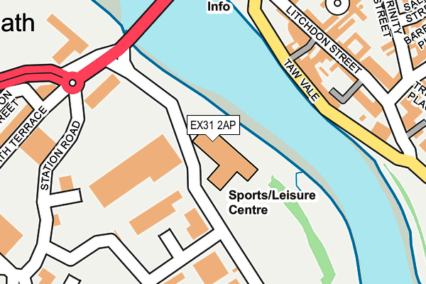
EX31 2AP is located in the Roundswell electoral ward, within the local authority district of North Devon and the English Parliamentary constituency of North Devon. The Sub Integrated Care Board (ICB) Location is NHS Devon ICB - 15N and the police force is Devon & Cornwall. This postcode has been in use since January 1980.


GetTheData
Source: OS OpenMap – Local (Ordnance Survey)
Source: OS VectorMap District (Ordnance Survey)
Licence: Open Government Licence (requires attribution)
| Easting | 255855 |
| Northing | 132728 |
| Latitude | 51.075722 |
| Longitude | -4.058998 |
GetTheData
Source: Open Postcode Geo
Licence: Open Government Licence
| Country | England |
| Postcode District | EX31 |
➜ See where EX31 is on a map ➜ Where is Barnstaple? | |
GetTheData
Source: Land Registry Price Paid Data
Licence: Open Government Licence
Elevation or altitude of EX31 2AP as distance above sea level:
| Metres | Feet | |
|---|---|---|
| Elevation | 10m | 33ft |
Elevation is measured from the approximate centre of the postcode, to the nearest point on an OS contour line from OS Terrain 50, which has contour spacing of ten vertical metres.
➜ How high above sea level am I? Find the elevation of your current position using your device's GPS.
GetTheData
Source: Open Postcode Elevation
Licence: Open Government Licence
| Ward | Roundswell |
| Constituency | North Devon |
GetTheData
Source: ONS Postcode Database
Licence: Open Government Licence
| Imperial Hotel (Taw Vale) | Barnstaple | 179m |
| Sticklepath Terrace (A3125) | Sticklepath | 215m |
| Sticklepath Terrace (A3125) | Sticklepath | 265m |
| Station Entrance | Barnstaple | 342m |
| Rail Station (Station Road) | Barnstaple | 353m |
| Barnstaple Station | 0.3km |
GetTheData
Source: NaPTAN
Licence: Open Government Licence
GetTheData
Source: ONS Postcode Database
Licence: Open Government Licence


➜ Get more ratings from the Food Standards Agency
GetTheData
Source: Food Standards Agency
Licence: FSA terms & conditions
| Last Collection | |||
|---|---|---|---|
| Location | Mon-Fri | Sat | Distance |
| Seven Brethren | 18:15 | 12:00 | 104m |
| Infirmary | 18:15 | 13:00 | 285m |
| The Square | 17:30 | 12:45 | 298m |
GetTheData
Source: Dracos
Licence: Creative Commons Attribution-ShareAlike
| Risk of EX31 2AP flooding from rivers and sea | Medium |
| ➜ EX31 2AP flood map | |
GetTheData
Source: Open Flood Risk by Postcode
Licence: Open Government Licence
The below table lists the International Territorial Level (ITL) codes (formerly Nomenclature of Territorial Units for Statistics (NUTS) codes) and Local Administrative Units (LAU) codes for EX31 2AP:
| ITL 1 Code | Name |
|---|---|
| TLK | South West (England) |
| ITL 2 Code | Name |
| TLK4 | Devon |
| ITL 3 Code | Name |
| TLK43 | Devon CC |
| LAU 1 Code | Name |
| E07000043 | North Devon |
GetTheData
Source: ONS Postcode Directory
Licence: Open Government Licence
The below table lists the Census Output Area (OA), Lower Layer Super Output Area (LSOA), and Middle Layer Super Output Area (MSOA) for EX31 2AP:
| Code | Name | |
|---|---|---|
| OA | E00101901 | |
| LSOA | E01020124 | North Devon 009C |
| MSOA | E02004183 | North Devon 009 |
GetTheData
Source: ONS Postcode Directory
Licence: Open Government Licence
| EX32 8NJ | Taw Vale | 165m |
| EX32 8NN | Litchdon Street | 171m |
| EX32 8LT | Litchdon Street | 184m |
| EX32 8NL | Litchdon Lane | 190m |
| EX32 8ND | Litchdon Street | 213m |
| EX32 8AY | Litchdon Street | 241m |
| EX31 2AX | Osborne Terrace | 248m |
| EX32 8LS | The Square | 270m |
| EX32 8QL | Barum Court | 283m |
| EX32 8JB | Trinity Street | 289m |
GetTheData
Source: Open Postcode Geo; Land Registry Price Paid Data
Licence: Open Government Licence