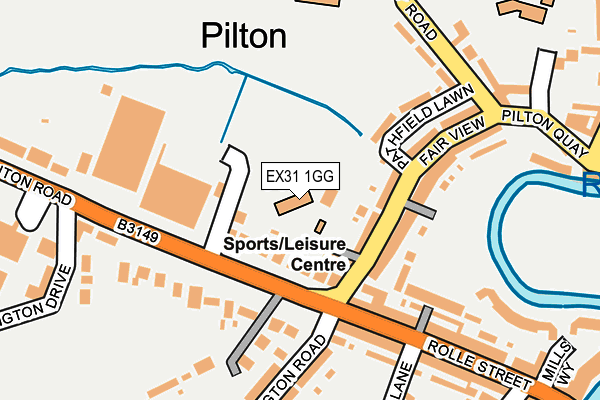
EX31 1GG is located in the Barnstaple with Pilton electoral ward, within the local authority district of North Devon and the English Parliamentary constituency of North Devon. The Sub Integrated Care Board (ICB) Location is NHS Devon ICB - 15N and the police force is Devon & Cornwall. This postcode has been in use since June 1998.


GetTheData
Source: OS OpenMap – Local (Ordnance Survey)
Source: OS VectorMap District (Ordnance Survey)
Licence: Open Government Licence (requires attribution)
| Easting | 255364 |
| Northing | 133753 |
| Latitude | 51.084810 |
| Longitude | -4.066412 |
GetTheData
Source: Open Postcode Geo
Licence: Open Government Licence
| Country | England |
| Postcode District | EX31 |
➜ See where EX31 is on a map ➜ Where is Barnstaple? | |
GetTheData
Source: Land Registry Price Paid Data
Licence: Open Government Licence
Elevation or altitude of EX31 1GG as distance above sea level:
| Metres | Feet | |
|---|---|---|
| Elevation | 10m | 33ft |
Elevation is measured from the approximate centre of the postcode, to the nearest point on an OS contour line from OS Terrain 50, which has contour spacing of ten vertical metres.
➜ How high above sea level am I? Find the elevation of your current position using your device's GPS.
GetTheData
Source: Open Postcode Elevation
Licence: Open Government Licence
| Ward | Barnstaple With Pilton |
| Constituency | North Devon |
GetTheData
Source: ONS Postcode Database
Licence: Open Government Licence
| Fairview (Braunton Road) | Pilton | 76m |
| Fairview (Braunton Road) | Pilton | 83m |
| Two Rivers Industrial Estate (Braunton Road) | Pottington | 217m |
| Two Rivers Industrial Estate (Braunton Road) | Pottington | 231m |
| Pathfield School (Abbey Road) | Pilton | 259m |
| Barnstaple Station | 1.2km |
GetTheData
Source: NaPTAN
Licence: Open Government Licence
GetTheData
Source: ONS Postcode Database
Licence: Open Government Licence


➜ Get more ratings from the Food Standards Agency
GetTheData
Source: Food Standards Agency
Licence: FSA terms & conditions
| Last Collection | |||
|---|---|---|---|
| Location | Mon-Fri | Sat | Distance |
| Pilton Bridge | 17:45 | 12:45 | 389m |
| Pilton Street Post Office | 17:30 | 12:30 | 390m |
| High Street | 18:15 | 12:00 | 420m |
GetTheData
Source: Dracos
Licence: Creative Commons Attribution-ShareAlike
| Risk of EX31 1GG flooding from rivers and sea | Low |
| ➜ EX31 1GG flood map | |
GetTheData
Source: Open Flood Risk by Postcode
Licence: Open Government Licence
The below table lists the International Territorial Level (ITL) codes (formerly Nomenclature of Territorial Units for Statistics (NUTS) codes) and Local Administrative Units (LAU) codes for EX31 1GG:
| ITL 1 Code | Name |
|---|---|
| TLK | South West (England) |
| ITL 2 Code | Name |
| TLK4 | Devon |
| ITL 3 Code | Name |
| TLK43 | Devon CC |
| LAU 1 Code | Name |
| E07000043 | North Devon |
GetTheData
Source: ONS Postcode Directory
Licence: Open Government Licence
The below table lists the Census Output Area (OA), Lower Layer Super Output Area (LSOA), and Middle Layer Super Output Area (MSOA) for EX31 1GG:
| Code | Name | |
|---|---|---|
| OA | E00165928 | |
| LSOA | E01020132 | North Devon 007A |
| MSOA | E02004181 | North Devon 007 |
GetTheData
Source: ONS Postcode Directory
Licence: Open Government Licence
| EX31 1GH | Braunton Road | 64m |
| EX31 1JR | Fair View | 74m |
| EX31 1GA | Braunton Road | 144m |
| EX31 1JW | Rolle Street | 155m |
| EX31 1JS | Fair View | 162m |
| EX31 1JX | Roselyn Terrace | 169m |
| EX31 1JH | Pottington Road | 214m |
| EX31 1GL | West End | 224m |
| EX31 1LD | Pottington Drive | 231m |
| EX31 1JN | Rolle Street | 235m |
GetTheData
Source: Open Postcode Geo; Land Registry Price Paid Data
Licence: Open Government Licence